DEATH VALLEY BUTTES (3,017'),
COFFIN PEAK (5,503'), NOPAH (6,394'), AND AVAWATZ MOUNTAIN (6,154')
March 10-14, 1999
Having
signed up with the DPS for two peaks which I needed, I left to
enjoy another long drive south on U.S.
395. Taking some photos along CA
136 and CA 190, I enjoyed
the soft dusk light.
C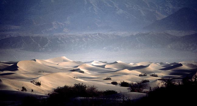 oming
to Death Valley, I shot photos of the morning
light at Mesquite Dunes, with a quick visit to the Devils
Cornfield, and then motored to the start for a short
hike of the two Death Valley Buttes. I had read of this short
hike in a major paper, and it seemed easy enough to try alone.
So close to the highway, one could probably shout to a passing
car and even be heard!
oming
to Death Valley, I shot photos of the morning
light at Mesquite Dunes, with a quick visit to the Devils
Cornfield, and then motored to the start for a short
hike of the two Death Valley Buttes. I had read of this short
hike in a major paper, and it seemed easy enough to try alone.
So close to the highway, one could probably shout to a passing
car and even be heard!
I found a use trail, and topped on the
highest point after 1.3 hours. The views were a bit bland, but
I took photos anyway.
While headed east on CA 190, I shot a picture
of Pyramid Peak (6,703'). One wouldn't guess this spectacular
view after seeing the peak from its other side.
I then drove the 40 miles or so, from the
parking for Death Valley Buttes, to Dante's View (5,475'), where
the view down into Death Valley is awesome. A small peak nearby
can be easily hiked from the parking lot up here.
I shot a lot of pictures.
This was my first visit up here, and the views were as good as
from many desert peaks. At Dante's View, signs explained the natural
features. Many tourists come up here, since the road is paved.
A mine, with colorful rock,
is passed enroute, and that prompted me for a few shots. This
is one park where mining was allowed. Plans for another mine to
open in designated wilderness were presented recently.
After motoring back down the paved road
a short bit, I parked at the RV lot and hiked eastward.
I climbed nearby Coffin Peak, which took
about an hour. It had good views
south into Death Valley. I had fun reading the register in the
cairn on top.
With a fast
photo stop at Zabriskie Point, and going back down to the
main road southward through the valley, I enjoyed the orange
light as the sun set. Camping near Shoshone, CA, I met the
group the next morning.
It had been required to attend to have 4WD transportation. If you didn't have such a vehicle, or a carpool op for that, you were disallowed. That I told the leader of the 4WD requirement to be unnecessary for doing this peak, aside from the quarter mile of flat hiking, this was refused. Something like that they wanted to keep such people out. So, I had to arrange for transport once I arrived, by the trip sheet ops. Lucky for me, I got some assurance for a ride.
We carpooled a bit to the end of the short
4WD road to hike to Nopah. This peak is the range highpoint of
the Nopah Range, of course. The usual geology made a nice
picture, and we topped out after about 5 hours. I was pleased
that I had done the 4,200' gain so nicely.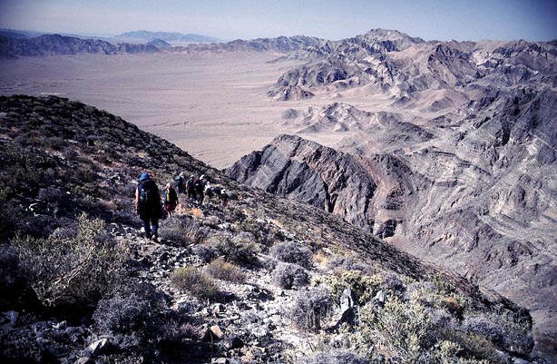 The views were fine, and I had
a nice time on my descent.
The views were fine, and I had
a nice time on my descent.
Back to the cars at 5 p.m., with a view
back to Nopah, we headed for Tecopa Hot Springs. We had a good
soak. Finding a place nearby to camp, we feasted on the potluck
dinner, with lots of salad.
The next morning, I was able to secure
a seat in another climber's truck for the long, rough ride to
the Avawatz Mountain roadhead. Without a good 4WD vehicle, this
would make another 8 miles or so each way to hike. There was a
wash-out shortly before we reached the furthest that we could
go, so we parked our trucks and began hiking.
A dirt road is followed, then a cross-country
climb up to a ridge leads to the summit. Our time to the top was
about two hours and forty minutes. The overcast sky made all of
the photos grayish, but I
needed the proof of our climb.
We hiked back the same
way, and drove back out to the paved highway by 4:20 p.m.
Again, I made the long drive home, this time with lots of daylight.
My total hiking stats were some 21 miles
with 9,500' gain.
BACK TO PETE'S
THOUSAND PEAKS HOME PAGE