 Leaving
home by about 4:40 a.m., I motored the shortcut route through
Valley Home, CA, to have breakfast in Oakdale, CA. The sun rose
in an opportune fashion, and driving up CA 120, I watched for
icy spots further along.
Leaving
home by about 4:40 a.m., I motored the shortcut route through
Valley Home, CA, to have breakfast in Oakdale, CA. The sun rose
in an opportune fashion, and driving up CA 120, I watched for
icy spots further along.SNOW CREEK TRAIL March 7, 2004
With a bit of insomnia this weekend night, I rose from an attempted sleep to decide to go to Yosemite National Park. We here in the Central Valley have this highly proximate, magnificent opportunity to enjoy in this most scenic of locales, with an easy day's journey.
Leaving
home by about 4:40 a.m., I motored the shortcut route through
Valley Home, CA, to have breakfast in Oakdale, CA. The sun rose
in an opportune fashion, and driving up CA 120, I watched for
icy spots further along.
Entering the park, I flashed my park pass, and wondered what I would do today. There seemed to be a lot of snow, making hiking less desirable. Coming into the Valley proper, I stopped for the standard photos at the view areas along the park main road. The falls were all running well, and the sky was clear blue.
Parking at the Village, I sauntered over to the visitor center to find that I might do the Snow Creek Trail. This south-facing slope affords sometimes snow free hiking. The other trails seemed out, with plenty of snow still on the Valley floor.
Driving over to the Stables parking, I began my hike at 10:18 a.m. It was chilly in the woods, and I wore four layers, at first. The closed asphalt road leads to Mirror Lake, where photo ops abound. Ice on the road required some careful, steady footwork.
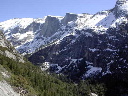
Continuing along the trail up Tenaya Creek, I hiked through oaks, incense cedar, and pines. A junction is signed, and alerts one to the Snow Creek Trail heading northward up the canyon slope. I had climbed this trail in winter once before, and it offered nice views. A descending couple said I could probably make it to the rim, but they hadn't gone very far.
Carrying my full day pack, I ascended up the rocky trail, which switchbacked tediously. The view across the canyon was spectacular, with snow and ice covering the northwest face of Clouds Rest. A small creek cascading over cliffs marked the trail up higher, and massive, overhanging, slabs above, added to my sights.
Snow began to cover parts of the trail
in short sections, and I was able to hop over patches. I surmised
I had gone up 2,000 feet elevation gain. I remembered I had gone
higher four years ago, and I knew there would be more snow on
the trail. At a view of Half Dome, I rested and drank my water.
I was now stripped down to a light T and jeans, with a load of
polyester now in my pack. It was quite warm in the sun.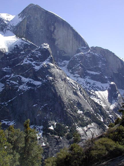
The rim of the valley loomed hundreds of feet higher. It was almost 1 p.m. I called it, and began my descent back to the Valley. I snapped several photos of the view, and of myself with Half Dome in the background.
Encountering other hikers, one couple was clad in swimwear. The air temp was right for that! I anticipated getting back to the level trail on the canyon floor.
A group of hikers pointed out a snow avalanche occuring on the face on the other side. I had heard frequent rumblings of rockfall, but presuming they were so distant, and hard to spot, I refrained from movie clips. I was to see three other snow avalanches, with snow exploding as it hit a rock, and powder streaming down cliffs and faces.
It's just my luck that such sights not be recorded, me figuring such small slides make for little interest to others. It takes me too much time to set the camera for movies, and the snow falls were over quickly. My hands are not very steady for a telephoto shot. I would need to find a viewpoint, and have my camera ready for the next avalanche. This does take time. And I needed exercise, first.
I continued to see avalanches, with other hikers watching, too, as far down as Mirror Lake. They were just too distant to fill the frame. Coming back to my car by 3:05 p.m., I headed out of the park to go to the tunnel view along CA 41. I snapped a few obligatory shots, and then sauntered the Bridalveil Falls trail to shoot movies of the waterfall.
I had enough. Leaving the park, I again noted all the snow about Crane Flat, where I recall starting a three day snowcamp, with cross-country skiing, a few years ago.
The sunset wasn't much, and a traffic slowdown along CA 120 was due to a car crash. In Oakdale, I ate some tacos and drink for energy, then arrived home at a reasonable hour.
I hiked maybe some 10 miles with 2,000' gain. I shot over 200 images, and used only about 3/4 of a tank of fuel.
BACK TO PETE'S THOUSAND PEAKS HOME PAGE