DOGSKIN MOUNTAIN (7,487') January
1, 2001
The
Sierra Club, Toiyabe Chapter, Great Basin Group, scheduled this
widely advertised, "recovery hike," for the day after
New Year's Eve. They have been doing this for several years now.
The meeting time was set late, at 10 a.m., giving me plenty of
time to drive up and meet them. I noted the snow
conditions enroute.
 The
23 or so of us, with four dogs, generally carpooled from Reno's
UNR campus, as several miles of dirt road have to be driven.
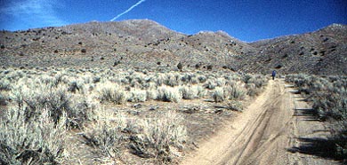
Taking Pyramid Way, NV 445, we drove some
15 miles north to Winnemucca Ranch Road, which starts paved, but
turns to dirt. A good dirt road turns left (south), then circles
the range to its southwestern side. Another unsigned road heads
toward the south slopes of the peak, with turns, fences, and a
wire gate. I feared getting stuck in sand, but all cars made it.
The
23 or so of us, with four dogs, generally carpooled from Reno's
UNR campus, as several miles of dirt road have to be driven.
Taking Pyramid Way, NV 445, we drove some
15 miles north to Winnemucca Ranch Road, which starts paved, but
turns to dirt. A good dirt road turns left (south), then circles
the range to its southwestern side. Another unsigned road heads
toward the south slopes of the peak, with turns, fences, and a
wire gate. I feared getting stuck in sand, but all cars made it.
Doing research, I believed initially that
a northwestern point, at 2275 meters, was the range highpoint,
since the map showed that a benchmark "Dogskin," was
sited there. The leader, at the trailhead, showed me another map
giving a peak right above us at 2282 meters. This was great! I
had determined this middle peak only as 2250+ meters, so had incorrectly
wanted the benchmark point.
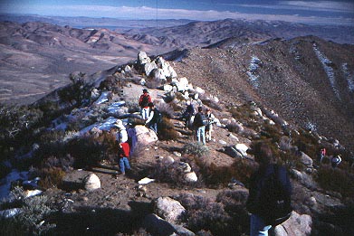 Starting
our climb at about 11:30 a.m., we took a dirt road, then dirt
bike trails up a ridge and onto a wide slope, then headed cross-country up the hill. A prominent
rock outcrop was said and seen to be the top. Thus, navigation
was easy. We sidehilled a bit, then had lunch by some granite
boulders.
Starting
our climb at about 11:30 a.m., we took a dirt road, then dirt
bike trails up a ridge and onto a wide slope, then headed cross-country up the hill. A prominent
rock outcrop was said and seen to be the top. Thus, navigation
was easy. We sidehilled a bit, then had lunch by some granite
boulders.
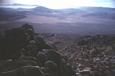
The day was cold, but sunny and clear.
Haze lay in the valleys to the south. The faster hikers went on
to the top, with some patches of snow, and views of distant peaks
plus part of Pyramid Lake. Soon, all that wished the top arrived,
and I placed a register. It had taken me some 2.5 hours to top
out.
We claimed being the FIRST for the THIRD
MILLENNIUM. It was glorious!
The view included
the hazy valleys to the south. Mt. Rose was seen, and someone
said Seven Lakes Mountain. Tule Peak was to the northeast, the
highest one in the area.
Our views extended well into the Great
Basin. I thought I saw Adams Peak, and other Sierra summits. A
distant peak was guessed as Lassen Peak, but I suggested Sierra
Buttes.
We wanted to get warm, so headed down after
about 30 minutes. The loose sand and dirt allowed us to plunge
down quickly, so we were all back to the cars after about an hour.
 I
left ahead, since I have to drive slowly on washboarded roads.
I came back to Reno to celebrate with a great buffet dinner, with
still big holiday crowds about. Caught up in a traffic jam going
over Donner Summit, I concluded my activity with an expedient, and
most importantly, a safe return. The hike stats were some 1,800
feet of gain over some 3 miles round trip.
I
left ahead, since I have to drive slowly on washboarded roads.
I came back to Reno to celebrate with a great buffet dinner, with
still big holiday crowds about. Caught up in a traffic jam going
over Donner Summit, I concluded my activity with an expedient, and
most importantly, a safe return. The hike stats were some 1,800
feet of gain over some 3 miles round trip.
BACK TO PETE'S
THOUSAND PEAKS HOME PAGE