TIOGA PEAK (11,513'), SAN JOAQUIN RIDGE (10,255'), LAUREL MOUNTAIN (11,812') AND AN ONION VALLEY HIKE August 22-26, 2000
Badly
in need of an activity, I stayed for one night Tuesday in Reno,
NV, before making this drive south
along U.S. 395. I had signed up for an SPS trip to do Mt. Gould
(13,005') and Dragon Peak (12,955') over the coming weekend. These
peaks are near the Onion Valley trailhead.
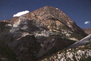
My first peak for conditioning was the easy Tioga Peak, climbed from the Gardisky Lake trailhead along the Saddlebag Lakes Road off Highway 120. There is signed parking, and a short trail ascends steeply to the Gardisky Lake basin. Hiking south cross-country through some scrubby stands of pines, I took a distinct use trail which ascends the short ridge and comes to the summit 1,800 feet above the hike start.
Checking thoroughly for my old register
placement, I found nothing, except picking up a pair of print
gloves abandoned or forgotten by some other hiker. Leaving a modest
set of cans and book, I returned to the car after fifty minutes.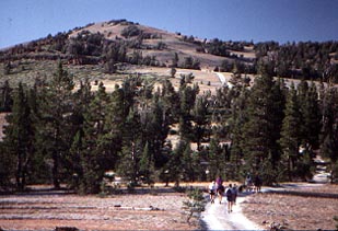 There
was a new sign to photograph,
I saw.
There
was a new sign to photograph,
I saw.
Motoring south to Mammoth Lakes, CA, I met a Sierra Club Range of Light Group activity to join their Wednesday evening hike, this time to San Joaquin Ridge (10,255').
Beginning from near Minaret Summit off CA 203, a jeep road is followed to the top. This was my first counted summer ascent, myself noting the vastly differing conditions compared to a ski climb during the snow season. The backlighted views of the Minarets and Mt. Ritter and Banner Peak served for some dramatically inclined photography, but with details lost. We hiked back to the cars, where it was found that two hikers had apparently taken a wrong turn on the maze of dirt roads here. A driver soon picked them up.
This ridge was considered to be one of the finest Nordic ski tours in the State, but at last check, is heavily used by snowmobiles. But, tourers, don't let this deter you from enjoying the classic winter views.
The next day, I repeated an ascent of Laurel Mountain from its base, at the 7,280 foot contour near the junction with the Laurel Lakes 4WD road and the Sherwin Creek Road. This offers a gain of about 4,600 feet. Many jeeps were using this official road today, but I didn't encounter them until later on my descent.
At about the 10,000 feet elevation, an unsigned trail leads left up to a pass which marks the northern boundary of the Convict Lake watershed. Steep rubble and scree hiking leads left again, and in about 1,000' gain, goes to the summit. Today provided some clear views of the surrounding mountains and basin. This summit has an historic Sierra Club register placement, one I added to, in 1995 on my first ascent, with a new book. A local resident provided another, smaller, new book on the first day of the new millennium, January 1, 2000.
I was pleased with my overall climbing
rate of about a thousand feet an hour. I took more pictures of
the view down to Convict Lake, and of the distant town of Mammoth
Lakes. After a modest stay, I carefully and slowly plunged down
the scree and loose rocks, and then followed the trail and the
jeep road back to my car.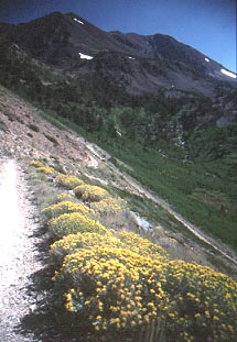 The rabbitbrush donated some more colors to this hike.
For my second night in Mammoth, with a nice sunset, I repeated a stay at a dorm-style lodge, which offers highly inexpensive bunk beds with a communal living room and kitchen. The residence was almost empty, being mid-week, so I slept well and was able to leave early.
After breakfast, I motored to Bishop, made some phone calls, and did some shopping and dining. Forty miles south in Independence, I had a slice of pizza at a new business, which now has recently opened to music fans and bar patrons.
The weather looked dubious. The High Sierra to the west was clouded over. Intending to meet the SPS group, which lost most of its sign-ups, I engined up to Onion Valley and met the trip leader there, in slight rain. I slept in the maintained campground parking lot at the direction of the camp host, since the regular sites were filled or reserved.
At 5 a.m., it was drizzling. I had my drink of liquid, and spoke with the trip leader and assistant. We all felt that we should scrub the climbs. They soon left for home, but I watched the weather. A good break in the clouds gifted me with sunshine, so I took the trail up to Golden Trout Lake. The billowing clouds and changing light made for plenty of photographic challenges. I visited all of the lakes on these forks of the trail, getting good views and great photos of Sardine Col, Dragon Peak, and Dragon Tooth.
Speaking briefly with another backpack
group, I had some rain going back to the hiker parking. Lightning
on the peaks, and then heavy rain, proved that our judgment call
was good.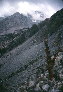
After short stops back in Independence and Bishop, I opted to drive home. The vistas of the clouds over mountain peaks offered more chances for photography. A colorful sunset over the Sweetwaters was my last photo for the trip.
My trip stats totaled about 23 miles hiked with over 10,000 feet gain.
BACK TO PETE'S THOUSAND PEAKS HOME PAGE