REYNOLDS PEAK (9,679') 4X July
17, 2001
 My buddy Fred
needed this peak to complete climbing all of the peaks on the
OGUL list, a compilation of 63 peaks about the Northern Sierra.
This list was developed by the Peak and Gorge Section of the Sierra
Club in 1981 or so. I have completed at least three ascents of
all of the peaks on this list, and am about 2/3 completed my fourth
time around. Fred had tried to climb this peak once before, but
failed due to the moderate technical difficulty. It is rated class
3, which is easy rock climbing. I had done it three times before,
so well knew the way, and being an experienced climber, offered
to help.
My buddy Fred
needed this peak to complete climbing all of the peaks on the
OGUL list, a compilation of 63 peaks about the Northern Sierra.
This list was developed by the Peak and Gorge Section of the Sierra
Club in 1981 or so. I have completed at least three ascents of
all of the peaks on this list, and am about 2/3 completed my fourth
time around. Fred had tried to climb this peak once before, but
failed due to the moderate technical difficulty. It is rated class
3, which is easy rock climbing. I had done it three times before,
so well knew the way, and being an experienced climber, offered
to help.
We motored to South Lake Tahoe the day
before, and secured a motel room to spare camping with the chilly
low forecast (35 degrees) and avoid mosquitoes. A sumptuous buffet
at a top Stateline casino provided us with plenty of carbos and
energy for the climb.
Having a simple breakfast in town the next
morning, we motored over to the Blue Lakes Road off Highway 88
and followed the roads to the 4WD access road up to the boundary
of Mokelumne Wilderness, in Indian Valley. Hiking by 8:11 a.m.,
we followed a faint track south, which soon ran out, and then
we headed cross-country around the right (west) side of a large
meadow. Our first objective lay to the south as the saddle of
the low ridge at the southern end of the meadow. Fred has bad
knees, so has to walk slowly. I have to keep him in sight, since
I know the way, and he doesn't. A pair of hikers can easily be
separated, then lost, in this forested and brushy terrain.
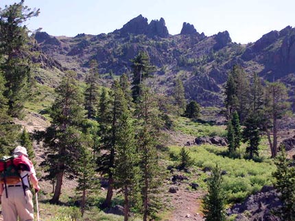
I hiked slowly ahead, looking for the best
ways to hike up. We began to climb up a rocky valley filled with
pinnacles and other rock formations, lovely and green with grasses
and shrubs. Flowers abounded, with reds, yellows, blues, and even
Mariposa Lilies. There are no trails, but the hiking is simply
uphill on dirt and loose rocks, with steeper sections. I enjoyed
taking pictures while I waited.
 Soon,
we came to a high pass in the main ridge, and I knew we would
get to the top. I had been afraid he would choose to turn back,
but he is one determined peak bagger! We had taken many rests,
and then I led along the easy high ridge to the base of the summit
pinnacle.
Soon,
we came to a high pass in the main ridge, and I knew we would
get to the top. I had been afraid he would choose to turn back,
but he is one determined peak bagger! We had taken many rests,
and then I led along the easy high ridge to the base of the summit
pinnacle.
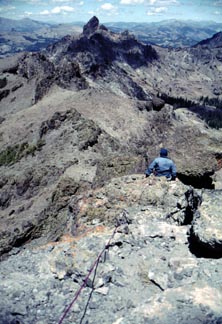
Telling Fred to wait, I quickly scrambled
to the top. There is a short knife-edge portion, which I hopped
over, accustomed to the hundred plus foot drop to both sides.
I carried my digital camera pack plus cans and a book, since I
was told the old register was gone. What a liar my friend has!
I had to inconvenience my climbing by holding these items, and
on my first descent, I could have dropped them. I also had to
worry about my own hand holds.
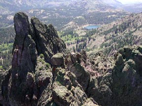
Many other airy
pinnacles were seen from this summit. Firsts might be done
on dozens of other little highpoints.
Having summited at 11:51 a.m., I put my
4X signature in the old register, a Northern Sierra classic I
had placed in 1984. I lost some nerve on the downclimb. It was
airy! I studied my moves, and finally descended on a sloping ledge
to the northwest side of the knife-edge. I warned Fred, waiting
below, that it was scary, and at first, didn't want to allow him
to do this. I had him climb up a easy bit, then went back to my
pack below to stash the intended new register, and take my other
camera up.
I had Fred go up ahead of me, up the easy
parts, to spot his footholds. There is one short vertical step,
with good ledges, then easy scrambling to the crux moves just
before the top. I had brought a 7mm 40 foot rope, which might
serve to hold a short slip. I set an anchor, and belayed him up.
 Because
the rope was short, I set up two pitches, one at the knife-edge
and one for the airy summit. Fred remembered his technique, and
with little fanfare, climbed up to the top. I had him sign in
quickly, then belayed him back down along the narrow knife-edge.
No problem! I had him give me a belay as well, to refresh his
knowledge, in case he would ever want to help me on other peaks
that I needed.
Because
the rope was short, I set up two pitches, one at the knife-edge
and one for the airy summit. Fred remembered his technique, and
with little fanfare, climbed up to the top. I had him sign in
quickly, then belayed him back down along the narrow knife-edge.
No problem! I had him give me a belay as well, to refresh his
knowledge, in case he would ever want to help me on other peaks
that I needed.
We came back to our packs, and left the
summit area by 1:32 p.m. Following the easy ridge back north to
a low point, I led Fred slowly back west, down the slopes with
the least gradient. I followed our footprints as best I could,
shot more photos, and rested often. Clouds accentuated the deep
blue sky. A gorgeous day!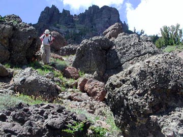
I did a good job navigating back, and we
arrived directly to our truck at 4:49 p.m. We left the parking
spot at 5 p.m., and were back to Highway 88, after my taking road
notes for the peaks guide, by 5:55 p.m.
Our stats today were some 6 miles with
maybe 1,800' gain, round trip. We had to cross many a dip across
gullies and hills. We had to don extra clothes on the high ridge
due to wind, and a warm cap was useful for Fred. There were a
very few mosquitoes about the meadow.
BACK TO PETE'S
THOUSAND PEAKS HOME PAGE