ARC DOME (11,778') AND SOUTH
SHOSHONE PEAK (10,063') May 25-26, 1985
 This was a
regular, scheduled, Climbing-Knapsack Section peak climb for this
Memorial Day holiday weekend. We all witnessed a spectacular sunset
Friday, while driving east
on I-80, then on Alt. U.S. 50. There was a rainbow, and brightly
lit, colorful clouds, well past Reno.
This was a
regular, scheduled, Climbing-Knapsack Section peak climb for this
Memorial Day holiday weekend. We all witnessed a spectacular sunset
Friday, while driving east
on I-80, then on Alt. U.S. 50. There was a rainbow, and brightly
lit, colorful clouds, well past Reno.
After my car camp, we met Saturday morning
at the International Hotel
in Austin, NV for a nice breakfast. It is a fine tradition that
we can have a great meal, in some leisure, with plenty of coffee
served.
Going back a bit west on Alt. 50, we took
the paved road going south along the Reese River Valley. A long
way south, after the road turns to dirt, a sign indicates the
turnoff for our trailhead. A high clearance vehicle is desirable
for the river and creek crossings,
and the washboarded dirt road to its end. My economy passenger
wagon did just fine, but some cars would have a problem in other,
higher, water years.
Two
other hikers were ready to go at
the Columbine Trailhead, on the west side of the Toiyabe Range.
It was about 9:30 a.m. We quickly had some trail finding problems.
There is a large, boggy meadow where the path becomes indistinct,
but one just heads straight across to pick it up on the far side.
Having good guidebook directions (Hiking the Great Basin,
by John Hart), we found the trail, and followed it up to where
it became more clear, and better.
The good trail ascends to the crest of
the Toiyabe Range, of which this is the southern part. Descending
slightly on the east side, a trail junction is followed right
and up south to a large, relatively flat, rocky plateau. We came
to a view of the glacial
cirque, with still plenty of snow, on the main ridge's east
side. There is another cirque, further along, on the west side.
Continuing along the summit
trail, an old jeep track comes up from the west. This is a
longer hike, but can be reached from our same trailhead (see guidebook).
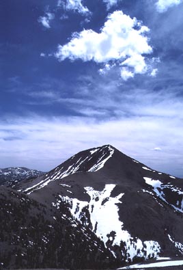
As we hiked toward the clearly distinct peak itself, the trail
begins to drop downward, and disappears. We headed cross-country
toward the summit, not wanting to let this spoil our fun. A field
of alpine wildflowers, with phlox, is sparsely distributed at
this high altitude. A cloud floated above the summit mass (photo).
As we came to the final uphill climb, the trail appears again,
and switchbacks to the top.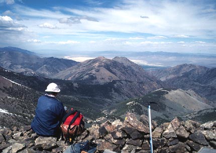
Our time was about five hours to the top.
A NAS register in a PVC pipe
awaited our signatures.
The Northern Alpine Section was another
peak climbing section in the same local chapter, with far more
numeric support. But, they have less drive and taste for ambitious
outings. At one time, it was the only group to go with, but with
limited goals. It was later geared to Singles groups, which probably
led ultimately to its demise. But before it went, the Climbing-Knapsack
Section was axed, and with it, the finest set of wilderness activities
that had ever been conducted in the area.
The two others relaxed in the summit rock
rings, and I took pictures.
The view was impressive. The Arc Dome Wilderness is probably the
nicest, wilderness, trail hiking op in the center part of the
state. There is another ascent route from the east, via the Twin
Rivers. This is said to be "the finest gorge" in the
Great Basin (John Hart, Hiking the Great Basin).
I was to hike the Twin Rivers loop in the next year.
The summit light was soft. There were some
high clouds. I snapped a lot of photos.
After I read through the register book,
we started back. We saw an impressive display
of the clear air and open country that, hopefully, will remain
forever undeveloped.
Back to the cars at dusk, we had a nice
car camp near the trailhead. We were joined late at night by another
climber for our second peak. I had been tired, and went to bed
early. I was quite out in my sleeping bag, laid out in the back
of my wagon.
 Sunday
morning, we motored back over to the main dirt road, then found
and took a dirt road west to the mouth of Bonita Canyon. Parking,
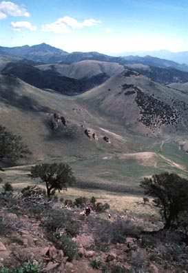
we hiked up the dirt track,
then went cross-country, by the north ridge, to the summit of
South Shoshone Peak. This was an easier, although trail less,
climb through sagebrush, pinyon pines, and mountain mahogany.
A cairn and register greeted us there, too. The skies were filled
with puffy clouds. It does rain,
even heavily, out here, so one has to watch the weather. We headed
back and came back to the cars early in the afternoon.
Sunday
morning, we motored back over to the main dirt road, then found
and took a dirt road west to the mouth of Bonita Canyon. Parking,
we hiked up the dirt track,
then went cross-country, by the north ridge, to the summit of
South Shoshone Peak. This was an easier, although trail less,
climb through sagebrush, pinyon pines, and mountain mahogany.
A cairn and register greeted us there, too. The skies were filled
with puffy clouds. It does rain,
even heavily, out here, so one has to watch the weather. We headed
back and came back to the cars early in the afternoon.
Since I had led the two peaks, with no
other climbs nearby, I terminated the trip and headed home, which
the others would do anyway after another night's camping.
Seizing an opportunity, I took the main dirt road south, and west,
to the Berlin-Ichthyosaur State Park. Arriving, just in time,
for the last ranger tour at 4 p.m. (1985), I was able to see the
fossils of an ichthyosaur.
This was a very large, fish-like reptile, or dinosaur, that lived
in an ocean, hundreds of millions of years ago. This is housed
in an expensive-looking building, which was impressive, for the
State of Nevada. This was considered a prime paleontologic find
at the time. I was to later come back here in 1998 to find that
much has been learned, or additionally supposed, about the ichthyosaurs.
I drove through the old town of Ione,
NV, then came back north to U.S. 50. I continued
all the way home. While camping is usually nice, I was concerned
about getting a good night's sleep at home, on my bed. Having
slept countless nights on the ground or in my car, I chose to
spend my day off in town.
BACK TO PETE'S
THOUSAND PEAKS HOME PAGE