March 30, 2014
 Up early again, I motored over to the gas station for diet soda. Resting in my room, I determined the weather. It was to get windier in the afternoon, so I had better do my peak hike early. An easy climb, others might do a couple such peaks in a day, but I had the wind coming up, and the lack of youth. So, having to check the maps for the layout of the town, I took U.S. 180 northwest, with directions from the USFS website.
It was overcast and windy. About 27 miles out of town, I found the forest road which leads to the trailhead. Before though, there is a similarly signed and numbered road that might cause some confusion. I know my peaks, and bearings, so knew about where it is. The road gets rough, with potential bad spots in muddy conditions, and I took pictures. Carefully driving with my passenger sedan, I was able to navigate to the signed trailhead parking. Some hiking clubs wouldn’t drive this road, being that they walk far better roads, using then a whole day to reach a destination, rather than say, ten minutes to hike, with my car and driving. With no facilities, too, I used a cup. My zip-lock baggie came in handy in case of a spill, despite the lid.
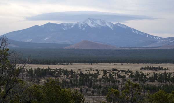
Starting the 2.4 mile hike, each way, I figured to take plenty of photos. This is a cinder cone of sorts, by the description, with a good view, by the government website. The trail has descriptive signs, then arrows. It curves about, and climbs at an easy grade. There were three or four fallen trees across the trail, so I did video as I stepped over them. I was coming to the top, and captured some views. The rain held off, but it was windy. It was due to get worse, so I did my photos and video. Trees blocked the view from the very top, with a small pile of rocks that held a glass jar with looseleaf papers and two pages signed in. I put my register entry, snapped a photo, then put it back to look for some better view of the San Francisco Peaks. With no more needs for photos, I sauntered down, and snapped some telephotos of the views as I came to better vistas.
No other hikers on this morning, then. Back shortly to the car, I motored off, and came back to the highway. Heading south back into town, there was a “Red Mountain Trail,” but I didn’t see it. Stopping at a nature point and cross country ski area with a big paved parking lot, I used the restroom, and went back to town.
The Northern Arizona Museum is along the way. Not too busy, it made for an hour or so visit, and I captured the displays for which photography is allowable. There was a nice artwork exhibit. Into the gift shop, the friendly help sold me on a couple of T-shirts and some locally made soap. There was an entrance fee good for the entire day, but I declined to return. Didn’t watch any movie, if any, as those are better displayed online. I can’t be waiting for showtimes and to spend time viewing what I would rather see at home, when I have more time, on my TV or other hi-res screen, with superior color and sound than the 20th Century film stock and projection.
Coming to the older part of Flagstaff, I found free parking, and walked about a few blocks. Another restaurant was closed, where I would have had ramen. Going to another eatery, I didn’t find what I wanted, so wandered into a place with healthier fare. Delighted to find this spot, I had a non-alcoholic beer, Shittake mushroom spring roll, and salad. Great! Back to my motel, I showered and lay in bed, resting again.
There was rain forecast for Wednesday. And wind for the next couple days. Perhaps due to climate change? In any case, I had the time to stop by Las Vegas, NV. So, searching on my bookmarked websites, I got a good low rate for lodging, so reserved for two nights. It was due to be windy there, too, so hiking might be out. But how could I be by the Southwest, and bypass Las Vegas!!??
2014 New Mexico Road Trip Home, 23, 24, 25, 26, 27, 28, 29, 30, 31, 1, 2, Movies
BACK TO PETE'S
THOUSAND PEAKS HOME PAGE