SAN FRANCISCO BAY LIGHTS March 9, 2013
 With perhaps a small cure to one of my medical ailments, I started to feel a bit better. This Saturday, I woke up at a late, but not bad, hour, and emboldened, had some plans at the ready. I did my research, and left home a little after 12:30 p.m. I had lunch, and then headed south on Interstate 5.
My first stop was at the Cosumnes River Preserve. I wished to check on what birds were there, and parked at the boardwalk lot. I carried my tripod, but few birds were to be seen. I went to the end of the planks, the viewing circle, but saw little. I did some video on my way back, and stopped by the visitor center. Plenty of people, but few birds.
Taking Twin Cities Road west, I came to the Delta Highway, CA 160. Turning south, I passed by the historic town of Locke, CA, without a stop, since many no parking signs warned tourists. I can come back here almost any day, so no big loss. I made a short stop at Walnut Grove, CA, with photos and videos. Crossing over the bridge here, to follow the route, I soon crossed back over to the east side of the river on another bridge. The signs warn that the levees are private property, so I didn’t stop and park for photos. Sun reflected off the river, with mighty Mt. Diablo rising in the distance.
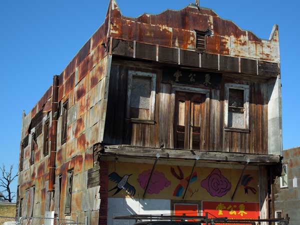
I soon came to Isleton, CA. I parked on the main side street, and began a short walk. The antiquated buildings made for photo ops, and I was reminded of some fine times here, dining, and being a side goal of my childhood bike tours. I soon needed a rest break, so looked by the large public restroom. It was closed. I gained the nearby vista of the river, and walked back to my car. I had a plan.
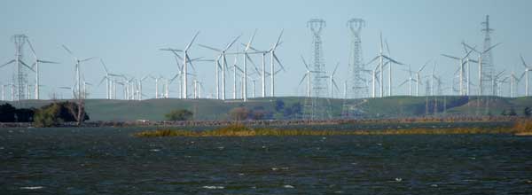
It is some 20 miles more to over the Antioch Bridge, and just past it, I exited to drive to Big Break Regional Shoreline. It has a good new visitor center, plus the nice facilities. This is a newer park, said opened in October, 2012, and I went inside the visitor center to be greeted by friendly staff. We spoke for a bit, and then I was shown the way to the viewing deck. It is a quarter mile or so of gravel and paved trail past some playfields, and then to the new vista of the lower Delta. Waves lapped at the rock shore, and I shot photos and video. Birds floated about on the stark blue waters, and the wind power generators in the distance made for a sight.
 Looking at my watch, I had a train to catch. Driving west on Highway CA 4, I came to the Pittsburg/Bay Point BART station at 4:30 p.m., and found that parking in the lot is free on weekends. There was plenty of room, so I walked the short distance to the station, paid my $12 round trip fare for where I was going, and a train was right there. I enjoyed the ride, as I have done many times, with a good seat. By 5:30 p.m., I came to Embarcadero Station, where I got off.
In San Francisco, I knew which way to go, and looked for eats on my way after my shoot. I crossed over the streets, and went inside the Ferry Building. I used the restroom, then strolled out on the promenade. It was busy, but not too crowded. I sat on a bench, with time to kill.
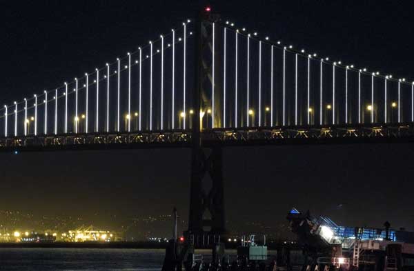
The sun set today at 6:11 p.m. I found a good spot on the railing to use my mini pod, and began to do video clips. I intended to have a slow transition of the passing of magic hour in my movie. The light faded, twilight started, and then the lights twinkled on. The Bay Lights are hard to see at first, but as it grows darker, they start to stand out. Many seagulls flew in front of my lens, and boats motored by. There were no clouds for drama, but I am just starting this. This light show will go on for the next two years.
 My battery finally ran low, so I halted to change it, and continued with more videos. Time passed by. It was soon past the time that I figured to stop this. I snapped my own photo, then did some more, last few, photos and video clips, and then looked for a quick bite. The restaurants were packed or booked up. Outside, I walked by the Embarcadero Center with views back, then figured to get back to my car.
I stood on the start of the BART ride home, then got a seat. Not many people headed out past the East Bay. I didn’t get any Wi-Fi connection, but listened to my music. By about 9 p.m., I came to the end of the line, and got back to my car. I knew where to go for dinner, and had a light burger with drink.
The Antioch Bridge is now $5 toll northbound, and I drove carefully up the darkened delta highway. I had ridden this road many times as a youth, so knew it pretty well. It is too dangerous for cyclists now, but I did see a couple. I thought back to the hiking club, and that many or most of them couldn’t properly drive this winding highway, with the often fatal swerves and plunges into the river by careless motorists. With fog, it can be lethal. I was soon back to Interstate 5 northbound, and back to town by 11 p.m.
Walking maybe two miles total, I had driven 148 miles. Spending under $28 total, I had gas already in my tank, using about 4 gallons. I captured 322 images and movie clips.
So, for 10 hours out of town, I got to see what is said to stimulate the local economy, and to see a non-repeating stretch of art. I wished for fine dining, but am on a diet, so have to be strict about stuffing myself.
BACK TO PETE'S
THOUSAND PEAKS HOME PAGE