OREGON COAST April 19-26, 2013
 Seeking to complete driving the major, trans-coastal range, highways in Oregon, I figured to use the fine Pacific Northwest forecast over the week of April 22nd to the 26th. I had been tracking the ten day for some time, and now, finally, it was time to go. I had an upgrade done to my connection speed and web host, so now, my website HD videos would start right away if I clicked on playing them, online. I also had some new tech toys to help in my hobby.
With the Net business taken care of this Friday, I left home by about 2:50 p.m. Making a stop at the electronics store for a new discounted camera, it was opened box only, so I didn’t take it. Getting gas at my favorite station for traveling northward, I shortly was motoring up Interstate 5. I never needed to stop, being that I was seeking to get quickly to my reserved economy lodging in Medford, OR. Mt. Shasta made for the usual sight, and I was zooming over Siskiyou Summit to arrive by dusk. Looking for a fine dining op, I drove over to Old Medford to have some food, and even a non alcoholic beer. On my tablet, I researched further for what I would do on this trip.
Awakening early every day, I felt better for this road trip, so Saturday, took the Interstate north to OR 138 westbound. It intersects with OR 38 to cross over the Coast Range. Umpqua Wayside made for a rest stop and photos. Stopping at an elk viewing point, I did some photos and video, then came to U.S. 101. Heading north, I had some sights to see again. I stopped at a park along the beach, then did a lot of video at a beach with a rock bridge. With more sights to see along U.S. 101, it was then to the visitor center at Waldport. There were civilized attractions, and then I made a longer stop in Newport. I took a short break at Yaquina Lighthouse. Along the way, I made a stop for ice cream.
My bucket list goal was to see the Three Capes. I passed by Pacific City, then took the scenic drive. First to see was Cape Kiwanda. Next, with more of a scenic drive, I took a hike to a view at Cape Lookout. Then, with the scenic drive, I came to Cape Meares. Backtracking a bit to get back to U.S. 101, I dined in Tillamook, OR. Driving then at night, I took OR 6 into Portland, OR, and came to my motel in Troutdale, late. I did more research with my tablet, and went to sleep.
 Sunday, I had to see Latourell Falls. The Columbia River Gorge Historic Highway was closed 5 miles from Corbett, so I took the Bridalveil Exit to go back west to the trailhead. The parking lot was now constructed, so I made the short walk to the falls, and then took a hike to the upper falls. It began to rain, so I canceled my plans, and went back into town to get my economy motel on Stark Street. I was told to check in later if I wished a better room, so I went to Mount Tabor Park for awhile, and motored about the streets. I then got my room, then took the 15 bus to my dining spot that I had found by the Net. Taking the 20 bus back, I walked over Interstate 205, and enjoyed, with a night snack, the start to my three night stay.
Monday, it was Earth Day. Most celebrations had taken place on Sunday, and not much was happening, even in the greenest city, by many. I took Interstate 84 east to have drink in Troutdale, then to Multnomah Falls for breakfast. Going over the Bridge of the Gods, I headed back west on WA 14 to the trailhead for Beacon Rock. Paying the fee, I started the short hike to the top of this historically significant and somewhat deadly outcrop, shooting video as I hiked up. This trail had re-opened a few days ago due to being closed by a rockslide. A few others hiked up as well, and I soon came to the top, with a view to the east. I hiked back down with more photos and video, then headed west on WA 14 to Camas, WA, where I took I-205 back to my motel.
Taking the 15 bus again, I debarked to walk to Water Avenue and then south to the Oregon Museum of Science and Industry. Paying the entrance fee, I toured the museum, and then to the Earth Sciences exhibits. Strolling north on the east side Willamette River bike trail, I took photos and video, then came back to Morrison Street. Taking the 15 bus to my dining spot, I had another fine meal, then took the 20 bus back to my motel. Free Wi-Fi saved on my 4G LTE data plan, and I streamed photos to the Cloud, but with no one to view them.
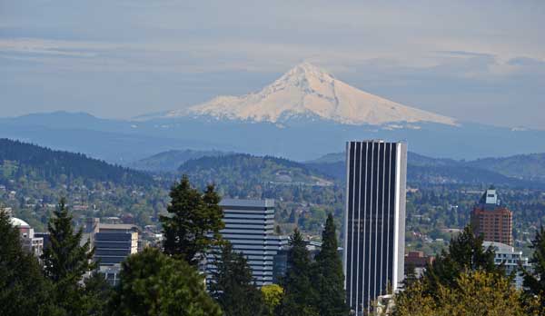
 Tuesday, I wished to ride the Tri-Met light rail. Walking the half mile to the station by the freeway, I obtained another day pass by machine, and rode the Green Line to Union Station in Downtown Portland. Meandering past Chinatown, I viewed more sights, then came to the Governor Tom McCall Riverfront Parkway, and headed south. First to see was the Japanese American Historical site, then some fountains. The mast of the USS Oregon made for another sight, and it was a nice morning. I came to the Hawthorne Bridge, and went west into Downtown. I passed various sights and artwork, then came to Pioneer Square. I toured the nearby Courthouse, restored to its original glory, going to the cupola on top for a view.
Wishing to enjoy the best of Portland, I took a walk over to the elevator to the 30th floor of a tower, and had lunch with a spectacular view. Finished, I walked back to Pioneer Square to take the light rail to Jeld-Wen Field, for the 63 bus to Washington Park, where I toured the Japanese Gardens, and purchased a few items at the store. Going by the Rose Garden which hadn’t been blooming yet, I came by the Holocaust Memorial, and then down a walkway to the bus station for a ride back into town. Going back up to the restaurant with a view, I had more dining, then rode the Green Line back to my motel.
Wishing then the elevated night view, I rode the Green Line back to Downtown, and had salads for a third luxury meal this day. Using my panorama feature, I captured the view to the south, and walked a bit looking for a restroom about the light rail station, seeing a seedy area of town. The ride back was fine, so my stay was done. Maybe when there is cheap bus service to Portland, I will be back.
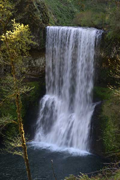
Wednesday, I headed south on 205 to Interstate 5, to exit at Salem, driving on OR 22 east to Silver Falls State Park. Taking OR 214, I stopped at a vistapoint, then came to the parking lot. I found the machine to pay, with signs to read, then began my hike. Passing the historic district, I wished to see the falls on the Ten Falls loop that I had not yet seen, but first viewed South Falls. There were then more falls and lovely sights along the trail, and I did video and photos. Lower South Falls, Lower North Falls, Double Falls, Drake Falls, Middle North Falls, and then Twin Falls were good. I backtracked to the Winter Falls trail to shorten my loop, having seen North Falls already. I took the Rim Trail back to the parking lot and my car, then motored back to Salem for lunch.
I took OR 22 west, bound for my motel in Lincoln City. Checking in, I went to the beach at Road's End, then to the nearby casino for dinner, and lost $8 gambling. I didn’t capture the sunset view from the dining area, as it wasn’t that great, and then enjoyed my tablet as was my habit. I had business to take care of, and hoped to extend my vacation, but the credit union didn’t seem too secure for online banking.
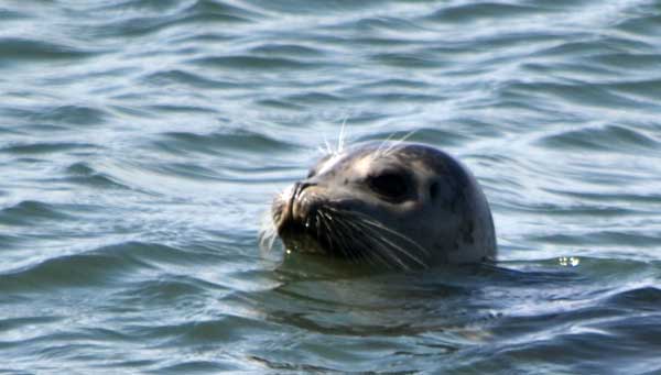
Thursday, I had more sights to see along the Coast. After a light breakfast, I hit a beach south of Lincoln City to see some sea lions, then to more sights and then to Cape Foulweather to get a myrtlewood trinket, then to Yaquina Head to have to pay the fee, despite being a free day for federal parks. There were sights on the stairs to the beach, then more sights on the way back up. Eagles were soaring overhead as I came to the nice visitor center, then I had a look at the displays at the rear of the cliff view. I took many photos of the displays inside, again. Supporting the gift shop, I bought a T-shirt. After a quick stop at Agate Beach, then a stop at the Alsea Bay Bridge, and then a hike down to Devils Churn and back, I dined on ramen in Newport, declining to re-photograph the area, as I had a major memory card failure, so wasn’t able to view some of my work, figuring to get the card manufacturer to retrieve the data.
Motoring south, I had to make a break stop at Yachats, pretty tired. Then it was to Cape Perpetua, and I motored up to the overlook. I wasn’t bothered as I declined to pay the self serve fee, being that one of the fee stations was taped up. This is managed by the USFS, so I guess was covered by the fee free period. The view here is said to be the best of the Oregon Coast, so I lingered awhile doing video, and then managed to capture my drive back down the two mile winding road, not through rain forest, but a continuous video op with no one else on the road.
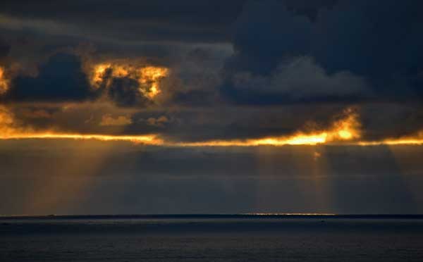
 Many signs along the highway indicated tsunami hazard zones, much more than on my visit in 2004. I had an eye open for a property investment, but didn’t see many for sale signs. A big sea quake would impact many areas severely, but historically, there hasn’t been any major disaster. Fiction tells of the great Cascadia quake, but the communities are prepared. I stopped for a view with the sun reflecting off the waters.
I stopped at the Umpqua Lighthouse State Park, doing a video at beautiful Lake Marie. I stayed for a time, anticipating a good sunset, but clouds blocked the view. Wandering about the buildings, I had to go here to use the restroom, which closes automatically at dusk. If locked in, there is a button to press to open the door. In the twilight, I drove south on 101 to Coos Bay, and my final stay.
Friday, it was foggy in the morning. I declined to revisit then Golden and Silver Falls, so took OR 42 east over another pass, to a park by Winston, OR. Taking Historic Highway 99, I came to Interstate 5, and zoomed south. More cheaper gas in Grants Pass would get me home, as I was running low on cash. With more sights ahead on Interstate 5, I stopped in Yreka for food, and then Mt. Shasta City, CA, to get information at the ranger station, then took the 10 minute round trip hike to Hedge Creek Falls. With a rest break at Shasta Lake City, historic Cottonwood made for another break, with more sights on I-5, food in Willows, and then, with a few photos ahead on Interstate 5, I came home by 7 p.m.
Hiking then maybe 15 miles with 1,500 feet of gain, I drove 1,685 miles. Paying from 3.439 to 3.599, I spent a total of about $155 for regular on the road, coming home with about 2 gallons in the tank, using maybe 43 gallons of fuel. Spending about $500 cash, I charged up some $350 for lodging, and then maybe $70 more for artwork and souvenirs. Shooting way over 4,000 images and movie clips, I have to take one card in for data retrieval, if possible, as my software seems incapable of doing the job.
At home, I am in bad need of more storage, as my computer is full up with various items. My downloads are taking overnight, and my back-up is slow, having to delete a number of files to clear up space to work. Fearful of online work, as when I left home, my computer was working at a crawl, and there was extreme frustration at doing basic things. I spoke with the tech support and sales help, and upcoming products are being delayed. Tracking the news, new hardware can’t come too soon, and my backlog of items to work on and post is becoming large. I need help!
BACK TO PETE'S
THOUSAND PEAKS HOME PAGE