UNDER CONSTRUCTION
FREMONT PEAK (3,171’) 4X, JACKS PEAK (1,068’), WILLSON PEAK (2,651’) December 8-10, 2013
 On a roll as far as my health, I felt O.K. on Sunday morning, so set out on Interstate 5 south. If not much exercise, I’d relax and do some sightseeing. I had had it in mind to enjoy seafood about Monterey, CA, and also to just take it easy. Stopping for food in Santa Nella, CA, I took CA 152 west over Pacheco Pass. Zooming then to about San Juan Bautista, I took the road up to the parking area at the Fremont Peak State Park.
This would be my 1,400th peak ascent. I had made weak plans to do this as my specific number, for coincidental reasons. Glad that I am past the 1,300’s, I had some superstition that I’d be unlucky somewhere. I took the easy trail to the top, with cold and slight wind. A family was by some rocks, and I scrambled on up, doing my camera work with no special celebration. I took telephotos, and then started down. It takes only some 17 minutes to get back to the car, and I set my video to record the drive down.
Back to CA 152, I motored over west to U.S. 101, then on CA 156 to Highway 1 south. Seeking to do some sightseeing, I drove over to Lovers Park, to do video and photos. Then, I came to Cannery Row, which is now a collection of shops, trendy and new. Paying the meter, I walked along the main street, snapping photos, and looking about. The sun was setting, making for a nice moment. Fremont Peak stood clear in the distance, and while I am not a big fan of the first Republican candidate for President, he did stand foremost in the exploration of the Pacific West.
Seeking some fine dining, I motored over to Carmel-by-the-Sea. I got free parking, and strolled along, snapping night photos of the window fronts and lights. Not very busy, I then took a side street to find a quiet dining spot. Having salmon filet, I took my time, and tipped well, to walk about a bit more. Taking CA 68 east to Salinas, CA, I had some economy lodging reserved for two nights.
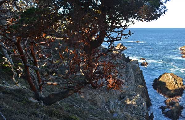 Up early Monday, I drank some diet soda that I had gotten for 99 cents for two liters. Surfing the Net, I determined what to do this day. It was cold, so I thought to decline hiking North Chalone Peak for my 4X. Figuring to hike by the Coast, I’d perhaps see some waterfalls or what. Having coffee and a sandwich at the fast food, I took CA 68 west, and stopped then at Point Lobos State Natural Reserve. Paying the $10 entry fee, I parked at Whalers Cove, and it was nicer here by the ocean. Informing some contacts of my change in plans, I used the restroom, and hiked on the North Shore Trail, one of my favorites. It was early in the morning, so I didn’t like the light that much, but did some video.
Coming then to the Cypress Grove trailhead, I used the restroom and chatted with the docents. Doing the short loop out to the Cypress Grove trail viewpoints, I liked doing video of the seabirds. Looking for a whale, I saw nothing, so left after a half hour. Climbing over Whalers Knoll, I got back to the car, and figured to head south. I had earlier checked out the road to Jacks Peak County Park, to find it was closed.
Tired, deciding then to save some fuel and driving, I headed for Carmel for lunch and wound up at the beach. Going then to Cannery Row, I looked for some dining. I had sand dabs, which I mentioned, to the help, of a 1950’s movie with James Stewart, which she remembered. He asked about what a fellow was cooking, and it had been, “Sand dabs.” I had some from the grocery store, but I don’t think that there are many places where you can get this. Doing dessert, too, I then motored off with time to spare on my meter.
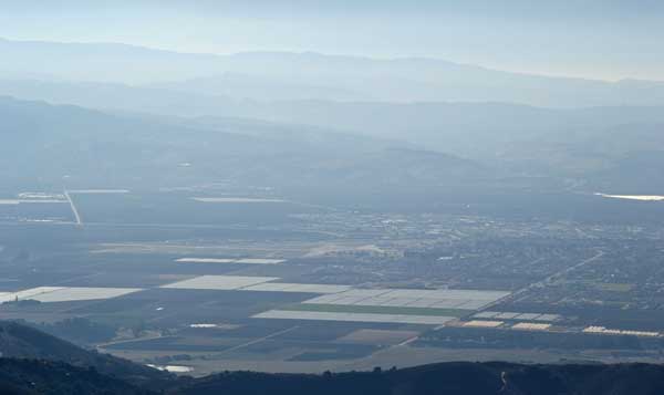
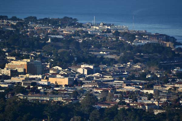
Going then to Jacks Peak Regional Park, I took the road up there to investigate this as a worthy hike. There is a trail that goes to the top, and my information from the Net was misleading. Taking the Skyline Trail, I shortly gained a good view of Monterey, taking some photos. The direct trail is said to be 0.6 mile, so this is no hard climb. The gain is only about 200-300 feet, but it is the high point of the Monterey Peninsula, albeit with higher peaks to the south.
 Topping out, there is no much of any view here, just a clearing of trees. I did my summit photos, and continued along the Skyline Trail. There are more views, and more views of the ocean, including Point Lobos in the sun reflected off the ocean. The trail does a circumnav of the peak, and I had to climb back up a bit to get back to the parking lot. I ran more video as I drove down, with more views of the town and ocean.
With daylight left, I headed back to Point Lobos. Going out on the Cypress Grove Trail, I sought to do time lapse video of the sunset. I had time, so didn’t have to rush. There was a lady watching the sunset right where I had figured to go, and I set my camera. She spotted a whale, telling me of it. I saw the tail rise up out of the water, but my camera was running wide angle and time lapse, and it was too dim to shoot good telephotos. Perhaps some of the whale appears as a small speck in my video, and I wondered if I could enhance it later. The park closes a half hour after sunset, said to me by the ranger as “5:20.” It began to get dark, so I stopped the video, and hiked back to the car, with still people out on some trails, though there is camping here. Driving out quickly, the gate was closed to incoming traffic, and I made it out with 7 minutes to spare.
Back to Salinas and my motel, I sought not to eat again this night, so retired early. The room heat wasn’t working very well, but as I am used to camping in the snow, didn’t think to do anything about it.
Up early Tuesday, I wasn’t comfortable with the cold, so went for breakfast at the adjacent restaurant. No Wi-Fi, there, so I went back to my room. If it had been better, I may have chosen to stay another night, as this was getting good. But then, I could be home back in my warm apartment, and to my computer and high speed Internet. I decided to do one final peak, and go home.
Taking U.S. 101 north, I zoomed to Gilroy, where I had diet soda and hash browns, then a peppermint mocha. Not able to clear my system fully, I motored up the road to the Hunting Hollow trailhead in Henry Coe State Park. Gratefully, they had outhouses, and looking at the stream, saw it was now dry, and no problem to cross.
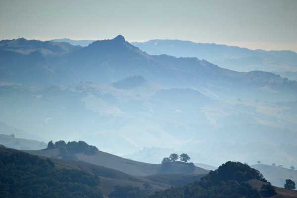 Willson Peak was an old grudge peak, and I was glad to be doing this. Sauntering up the dirt road over the streambed, I came to a sign stating peak trail, and the Jim Donnelly Trail. Taking it on up, it is a nicely graded and smooth single track, allowing for fast hiking. With no bicyclists coming down now, I enjoyed the hike on up. It passes through oak woodlands, me taking lots of photos. I surmised that I was doing great on time. Looking at my printed map, I sought to do good time, but came to the dirt road atop the ridge after 1:20. Having forgotten my pee bottle, it was just plain dirt and grasses, with animal scat about in spots, anyway, with no facility up here.
Taking the dirt road on to the top, I summited in 2:20, and started with photos and video. Blowing my nose a lot with tissue that I carried, I never took off my pack or drank water. I had some worry about accident, with mountain lion sightings in the Bay Area, too, so sent a message, with a good signal up here on top. No one that I know is interested in seeing photos from the top as I shoot them, and anyway, my Facebook page is private. No friends! Spending only 20 minutes on top, I took the Steer Ridge trail on down, to explore a different way. It is steeper, with some sections where I had to be careful stepping down, but it went fast, and back to my car by 1:05 p.m., my total round trip time was 4:05.
Nicer now in the sun, I used the outhouse, and washed my glasses. I stopped for lunch back at the fast food by Gilroy, taking my time. Wearing five layers on the hike, I had stripped down to two. It’ll heat up, and then I’ll have no further much use for my heavy winter gear. Wondering about what else to do, I’d get home early.
Zooming north on U.S. 101 to 680, I stopped for a rest in Cordelia, then got caught in some traffic before arriving home during magic hour.
Hiking about 10 miles with 2,500 feet of gain, I had strolled about towns for a mile or more. Driving 539 miles, I captured 1,123 images and movie clips. Spending about $210 in cash, I charged up about 100 for lodging. No souvenirs or keepsakes, I paid $26 in park entry fees. Used some 15 gallons of gas.
Feeling better as I returned home, it still wasn’t like the old days, with considerable slimming down after strenuous climbing. Dieting is foremost, with light meals, and avoiding snacking. Still with a long way to go to a more ideal weight and waistline, I’m looking at a bus trip to Southern California for more urban peak climbing and travel, with fine, healthy dining, keeping to light meals. No buffets or holiday gorging, as was the style of the old hikers, then their cessation of peak activity for the winter. Slim for me, not the heavyset girths, and fast going up, and fast going down!
BACK TO PETE'S
THOUSAND PEAKS HOME PAGE