YOSEMITE VALLEY VISIT January
9, 2010
 Finishing last year's walking season with a total
of over 1,600 miles, those all done right from home, some on the
Parkway, I am paying more mind to my personal carbon footprint.
I used only about 150 gallons of gas for the year, and with my
modest electrical use of mostly green tech items, this puts my
annual carbon dioxide emissions, by my carbon calculator, at about
2 tons. That is way down from some previous years' totals of about
10 tons.
Finishing last year's walking season with a total
of over 1,600 miles, those all done right from home, some on the
Parkway, I am paying more mind to my personal carbon footprint.
I used only about 150 gallons of gas for the year, and with my
modest electrical use of mostly green tech items, this puts my
annual carbon dioxide emissions, by my carbon calculator, at about
2 tons. That is way down from some previous years' totals of about
10 tons.
Buoyed with my reductions, and keeping
so much fun with my local hiking and dining, I figured to try
and get started on my new year's, 2010, travels. I'd use mass
transit.
Falling asleep at about 6 p.m., Friday
night, I woke back up at about 1:30 a.m., Saturday. I got to my
computer and thought of what to do this day. I had it in mind
to use the Yosemite Area Regional Transit System (YARTS) and pay
a winter visit to Yosemite Valley. It would be nice to see what's
new. I knew they had reconstructed the once classic, Yosemite
Falls vista point, in a nicer way, and that the snow would be
good to see. I had to kill some time surfing the Net. I printed
out the YARTS schedule, then dallied about on the Net, using time.
Leaving home then at about 4:30 a.m., I
took U.S. 99 south. Traffic was light. I figured to get a breakfast
stop along the way, as it takes me only 2 hours to get to Merced,
CA. I figured, too, to get to the Transportation Center at 16th
and M Streets, early, in case there were a lot of riders.
I was the only person to board the bus,
there. The fare now is $25, round trip. It left then at about
7 a.m., and picked up some more commuters at the Amtrak station.
I managed a few winks as we rolled along in the fog, then we were
treated to the sunrise. Picking up only a handful of riders, we
came to my stop in the Valley, the Village, at about 10 a.m. I
made sure not to lose my return ticket by zipping it up in my
parka pocket, and proceeded to the nearby visitor center.
The forecast had been for partly sunny,
or with a 10% chance of rain. It was diffuse light, so I'd do
photography. Snow blanketed the Valley floor, but the south facing
walls looked bare. I asked the ranger help, and they told me that
I should be able to make it to the rim. I watched the movie at
the adjacent theater, being the only audience. Next, I walked
through the Native American village replica, then the pioneer
cemetery.
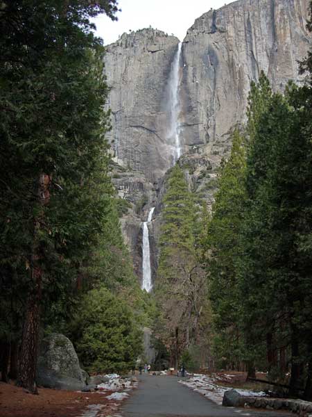
Various paved trails took me west to the
new falls vista that I had heard of. I managed not to slip on
the icy sidewalks, and then came to a vista of the lower falls.
Exploring more, I followed signs to the bridge at the base of
the Lower Falls. Another few tourists were about. I used my movie
setting to record the motion, and took more photos.
By now, it was close to 11:45 a.m. I figured
to try going up the Yosemite Falls Trail,
and the steeper grade told me I was out of shape. I had not done
any great gain since my hike in Zion National Park last fall,
and I sure felt it. It was nice to snap so many photos of the
trail headed up, though, and I liked the many rock steps.
Finally I came to Columbia Point (5,031'),
and rested a bit. I had managed to find an unlocked restroom back
down at Camp Four, so didn't have to pollute, today. The light
was in flux, and Yosemite Point (6,936') was just too far, today.
I didn't have the time that I wished, and due to my early rising,
feared that I might fall asleep on my drive back home. I had been
to Yosemite Point a few times already, and with white sky, the
view would not be too good for photos.
Two Spanish-speaking fellows came up, and
asked about seeing the falls. I recalled a nice view a bit further
up, so joined them to stroll up the trail a little more. You pass
some creaky looking rock supports, and then descend a bit to another
dip in the trail. The falls were going O.K., and there was a rainbow
in the mist. The snow cone at the bottom was developed well, and
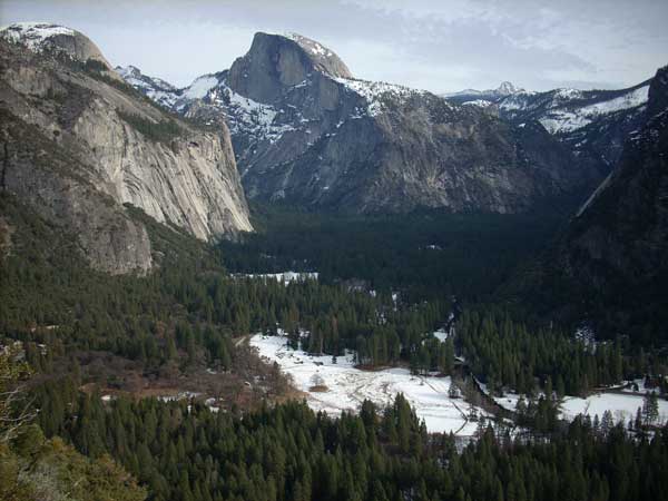
we stopped to chat about things. I took several photos
of the falls, and also Half Dome and Mt. Clark. Mt. Starr King
was also seen.
 After
awhile, we started back, and I stopped again at Columbia Point.
The view from atop Yosemite Point is higher, but you don't see
that much more. I had a lot of time, then, before my planned return
bus run came by at about 5 p.m. I took some photos of themselves
for other hikers, with their cameras, and then decided to start
back down.
After
awhile, we started back, and I stopped again at Columbia Point.
The view from atop Yosemite Point is higher, but you don't see
that much more. I had a lot of time, then, before my planned return
bus run came by at about 5 p.m. I took some photos of themselves
for other hikers, with their cameras, and then decided to start
back down.
I shortly came upon a hiker with one bare
foot, and wielding a large tree branch as a crutch. He indicated
that he had broken his ankle, but didn't seem to be in great pain.
He carried his boot, and had a sock wrapped around his ankle,
and I thought that I might have an ace bandage to wrap his foot.
I wondered if he understood English, and I asked if he might ride
a horse down. In first-aid class, it is important not to cause
further injury, if he had broken his ankle. He hobbled along,
and seemed capable to get down himself, slowly. I went on and
asked other hikers if they had a cell phone to call the rangers.
"No reception," I was told. It was only about a mile
further to the bottom, so I rushed ahead as best that I could
to seek to talk to a ranger.
I went to Yosemite Lodge where I tried
to get somebody's attention. The desk clerks were busy. I finally
wound up in the bar where the server got to their phone and let
me talk with a ranger. I reported the incident, and they didn't
seem to think that it was too much of a problem. The bar help
said that the rangers are really fast and had some wheeled stretcher
to carry people down. I waited a bit for any return call in case
they needed more information, then went to the food court to get
a drink. Going back to the bar, they said the rangers had not
called back. I expected that the hiker would get down and would
not have to walk on the snow with his bare foot.
It was starting to sprinkle lightly, and
I looked at my bus schedule. A run was shortly coming by. It was
getting darker, and with the light rain, I could do no more good
photography. It'd be nice to get back without falling asleep at
the wheel, too, but I was to be fine in that regard. I remembered
that I had driven home from Moab, Utah, without any sleep the
night before.
The YARTS bus came by at 4 p.m., and I
rode back, again with only a handful of riders. It was of some
note to see that the large rockslide down along the Merced River
Canyon had buried the former CA 140 highway. The engineers built
a single lane detour to go on the opposite side of the river.
I knew that YARTS had been using smaller buses due to the rockfall
problem, but now they were using the regular, large sized buses,
with some 40 or more seats. Being a weekend, I expected to see
more riders, but then the weather wasn't so good, and nothing
much was going on inside the park. I saw only one rock climber,
and a few deer grazing on dead leaves. Not any cross country skiers,
either, on the snowy meadows, or elsewhere. Although coverage
was patchy.
I had to strip down to two layers, from
four, as I hiked up the hill, and liked having my light, warm
underwear. I had only a small light day pack, with water and two
cans of soda. So, I hiked roughly some 5 miles with 1,000' gain.
I shot about 370 images and movie clips (640 x 480 pixels, 427 MB). I drove the 226 miles
to Merced and back, with a stop for a juicy burger, with a small
drink, and then a onion and chili covered hot dog, on my way home.
I used only a half tank of gas, about 5.5 gallons.
I will have to work on my uphill muscles,
and lose some more weight. The park is about the same, and I overheard
people saying it was "dead." The Badger Pass ski area
was said to be in need of more snow. I'd love to come back to
ski to Dewey Point, one thing that I haven't done in winter, or
round trip it to Glacier Point and back (20 miles) in a day. But
I am slowing up, and with no great plans in my future, still wonder
what I will be doing this year!
BACK TO PETE'S
THOUSAND PEAKS HOME PAGE