PANOCHE HILLS HIKES November 14, 2010
 Securing a past partner for this jaunt down Interstate 5, I had agreed to allow him to do as he pleased. I wasn't too aware that he was unable to navigate despite having a GPS unit, and perhaps thought highly of his own hiking ability and speed due to inaccurate readings from this unit. We had communicated by e-mail and phone, but it appeared that he has a poor ear for my words.
Nonetheless, we carpooled Sunday for this longer drive, and we came to the freeway exit by about 9:30 a.m. Taking side paved roads, we soon came to a likely dirt road, and I had viewed some photos from the Net to see what looked familiar. We had a map, and it led us to a high road with some parking. It was a quarter mile to our first destination, Panoche Hills highpoint (2,684'). I marveled that having done a hike here some 23 years ago, I was now back to claim the highest point of the Panoche Hills.
We did the short ten minute hike, and I began to take the pictures. I had updated software and could now work on special file formats. Hopefully, my web images will be much better.
We had a 4WD, but the roads were generally excellent, with lots of money spent to grade them. Motoring back to our next hike, my driver balked at using his vehicle to save us some one mile or so, each way, of hiking, due to his uncertainty about a rocky section. As we hiked along a dirt road, I could see some problems about our hiking together. He went ahead as I shot more photos, as it was quite desolate and unique.
Meeting him at the top of Panoche Mountain (2,091'), it had some towers on top for radio and what, and I wasn't going to scale the barbed wire fence to touch the true natural highpoint. Another hiker had climbed the tower, but that is not necessary for me, here this day. These bumps were unworthy of being counted.
We hiked back and motored on to our final goal, the highpoint of the Griswold Hills (3,224'). This turned out to be the best hike, but for more communication problems. I was told some things by some shooters at the developed trailhead, and then we took the dirt trail. I discerned that this was not as easy a hike as I had imagined, and advised to turn back. My partner sped onwards, and I had to stop for a drink of water and more photos.
Cresting a hill, he was nowhere to be seen. A bit concerned that he wouldn't know where he was going, I figured to stop and wait. I might have to have energy for a search and rescue op. He soon appeared, high on the hill, and yelled that he'd wait for me. I plodded up, and then asked about how far it was to the top.
It was 2:30 p.m. I heard, "1.8 miles," so decided to let him go on without me. I was feeling drowsy, and could use a rest. The vista to the north was awe-inspiring. I took more pictures.
 Looking at my device's maps, I saw that I was not so far from the top, but now it was too late. I just hoped that he could hike back to where I was. I mulled over my options, and would wait till it got too close to dark.
At about 3:40 p.m., he appeared again, and was headed down. It didn't take long to hike back down the steep trail, and I was back to the car at 4:15 p.m. We discussed plans, and soon were back to the Interstate with a reddish sunset.
Traffic seemed slow, so when we got to a Wi-Fi enabled eatery, I checked my traffic app. It was good to go home. I had some food, and then felt much better. I had not expected him to zoom ahead, but I like peaks, not hills. Home at a good hour, I got to my computer.
I had hiked about 8 miles with 2,000' gain. Capturing some 200 images, we had driven about 300 miles round trip from his area.
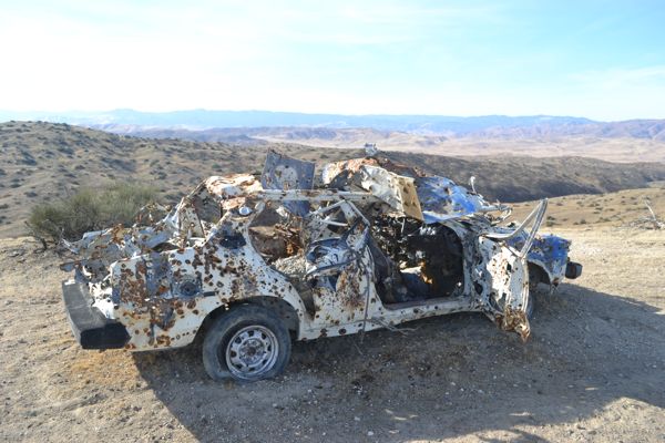
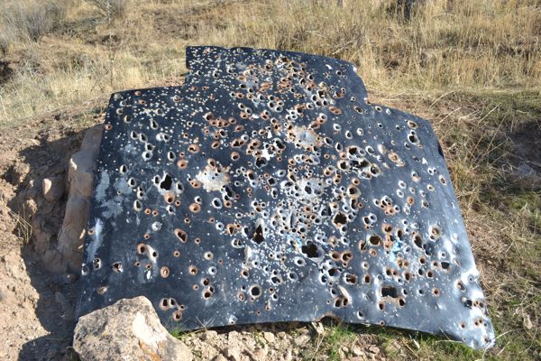
So now, I have achieved three points in the Panoche Hills, and have one grudge hike to revisit, maybe, someday. I would have rather gone to Yosemite Valley for the driving, but this was not my trip. The BLM has done much work in this area, although we never saw any other hikers. I was surprised that we had seen anybody, but had to be fearful of being shot by a stray bullet. Lots of gunfire.
Soon to be enabled for more traveling, I will be wondering what I will be climbing, as my ops are still limited.
BACK TO PETE'S
THOUSAND PEAKS HOME PAGE