FOLSOM BIKE TRAIL LOOP October
11, 2009
With
such fine weather and me finished up with all my post-road trip
business, I sought to do something this weekend. Slowing down
with only 10 miles walked about downtown the day before, I had
no one to carpool, climb, or hike anything, any distance away.
Having woken up early, I tended to my computer
and new toy issues, and then tried to figure what to do. Taking
light rail east to Folsom, CA, I had enough of my Lake Natoma
Loop. Arriving there at about 11 a.m.,
instead, I crossed over the old truss bridge and then headed right,
upstream. I knew they had completed building a new bridge, to
ease traffic congestion through Folsom. I had some sights
of nature, and saw many users on bikes, today.
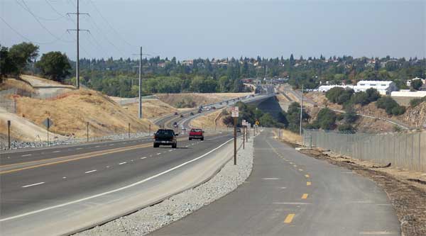 After
about an hour of leaving the train stop, I came to the brand new
road that crosses the American River. No pedestrian walkway or
bike trail is on the south, or downstream, side of this bridge.
One side, you had the scenic canyon
of the river and Folsom Prison, and the other, the dam and ugly
construction. It is a long walk, but they have built this new
section of bike trail. Nice of them to do that!
After
about an hour of leaving the train stop, I came to the brand new
road that crosses the American River. No pedestrian walkway or
bike trail is on the south, or downstream, side of this bridge.
One side, you had the scenic canyon
of the river and Folsom Prison, and the other, the dam and ugly
construction. It is a long walk, but they have built this new
section of bike trail. Nice of them to do that!
Over the bridge, I then came to a look
at Folsom Lake. It was not so low. All the security fences detracted
from the scenery. Ascending over a hill, I came to a traffic light,
and crossed over the road, following the bike trail east. It turns
into a gardened thruway past a subdivision, with decorative planting.
I knew I would make a loop, but had no map to tell me which way
to go exactly.
Walking further along East Natoma Boulevard,
there were malls and fast food places. I had a taco with drink
to refresh me. Following then Blue Ravine Road, there was a good
sidewalk, with redwoods, even, and I vaguely knew I was now making
a big loop. Then coming to East Bidwell Street, I turned right
again. I followed another short bike trail past a pond,
and then back onto the street that I was following. Coming then
to Riley Street, I read a bus sign map and saw the way to go.
Shortly back into Historic Folsom, I saw
I had some time, so ordered and consumed some delightfully tasty
soup. About now 4 p.m., I then caught a light rail car back into
town. Aside from plenty of traffic, nothing much was happening.
Home before the evening news, I showered
and got to my computer. I walked maybe 10 miles, with slight gain.
I captured over 165 images, and spent $5 round trip for the mass
transit, and $11 for food. With nice temperatures, I wore a pullover
and long pants, carrying only a belt pack.
I'll have to look at the maps, and now
figure out how to hike Carpenter Hill, the highpoint of Sacramento
County, using mass transit, for another thing to do. It looks
not too far using the Folsom buses, and despite the massive development,
would have a nice view if you like Folsom, and the rest of the
Valley, from there.
BACK TO PETE'S
THOUSAND PEAKS HOME PAGE