BOULDER PEAK (8,299') 2X, MT.
EDDY (9,038') 2X July 6-8, 2009
 After my slowness
on my previous couple peaks, I feared that my pursuit of my lifelong
love, peak climbing, was coming to an end. Dreading the day when
I should decide to hang it all up, I knew that with my aging self
and car, too, it was only a matter of when.
After my slowness
on my previous couple peaks, I feared that my pursuit of my lifelong
love, peak climbing, was coming to an end. Dreading the day when
I should decide to hang it all up, I knew that with my aging self
and car, too, it was only a matter of when.
With a few days of unusual coolness forecast,
I thought to avoid any possible altitude issues, and bag some
lower elevation peaks. Gambling on giving what might be my last
shot, I prepared my things, contingent on arising early enough
to do this.
Monday, the 6th, I woke up at about 6 a.m.
I had no enthusiasm for another little adventure, but that is
the way that I'm getting. I got to my computer and made my motel
reservations. At least, I'd get a good deal on lodging. Gathering
up my packs, I carried them out to my car, and left home at 8:16
a.m. So far, so good.
Having slept fairly well, I felt good enough
on my drive north on Interstate 5. I got a quick breakfast along
the way, and hoped to hike Black Butte (6,325') 3X to make this
a three peak trip. Getting to Mt. Shasta City, CA, by about noon,
I stopped at the ranger station, and then figured that it might
have been a bit too warm for that.
Driving up the lovely Everett Memorial
Highway, I figured on getting another repeat hike to the Sierra
Club hut. Going first to the old ski area parking, I was reminded
of my old climbs back in the 1980's. A few other tourists were
about, and I shot pictures of the
view.
Driving back down the road, I parked at
the Bunny Flat trailhead to hike to the Sierra Club hut. There
was a lot more snow on the peak than last year, and I enjoyed
feeling better than I did in 2008. I shortly reached the hut,
and opted to further check out the Oblerman's
Causeway.
Figuring to turn back at the end of the
line of rocks, I saw that a pretty good, scree, use trail of sorts
seemed to continue on. I kept going, and then ran into climbers
returning from the top. They said that this trail ran all the
way to the top, aside from the residual snow and ice on route.
This sure surprised me. I viewed climbers following switchbacks
down the rubbly hill, so resolved to explore this further at a
later time. I have had many wannabes ask if there was a trail
to the top of Mt. Shasta. I usually told them that it's scree
and pumice, and then snow and ice. Was that now wrong!
Heading back for the car, I shortly motored
off to get my motel room in Yreka, CA, and have some dining of
choice. I was able to do some magic hour photography
in the old part of town, having arrived there too late on my short
trip back in 2007.
 Falling
asleep well enough, I got some few hours of shuteye, waking up
again at about 6 a.m. I had a hard peak planned. This was a juncture
point in my life. I could forever give up tackling my peak challenges,
and go to road tripping sans any high adventure. Or, I could return
briefly to this Club-declared masochism. I got my breakfast sandwich
and diet drink, and then headed for my peak.
Falling
asleep well enough, I got some few hours of shuteye, waking up
again at about 6 a.m. I had a hard peak planned. This was a juncture
point in my life. I could forever give up tackling my peak challenges,
and go to road tripping sans any high adventure. Or, I could return
briefly to this Club-declared masochism. I got my breakfast sandwich
and diet drink, and then headed for my peak.
Taking Highway 3 to Fort
Jones, CA, I found my road to the Boulder Creek Trailhead.
Most of the roads for this trip were paved, but here, I had about
two miles of rougher dirt road to reach my objective. The road
signs were helpful, and I kept re-evaluating my desire versus
my plan. Coming to the primitive trailhead, other cars were there.
Glad that I might not be alone, I started
up the trail by 7:50 a.m. Inspired by the forest
beauty, I kept up my pace.
I remembered from my club lead in 1986
that we just spritzed up the peak, and thought it was no big deal.
My USFS Marble Mountain Wilderness map showed the trailhead at
2,900 feet elevation. That'd make the total gain some 5,300 feet.
I thought that was wrong, and recalled that it was more like 4,000
feet of gain. I had no solid notes aside from my Kodachrome slides,
which I had not reviewed, recently. I'd see how I did.
Reaching a trail junction, the map showed that I was at 6,400
feet elevation. Great to know this, for I had then made good time.
Only then some 1,900 feet from the top, I gingerly continued.
More trail junctions led me on, and then I was hiking through
overgrown trail, with my 23 year old memory leading me on.
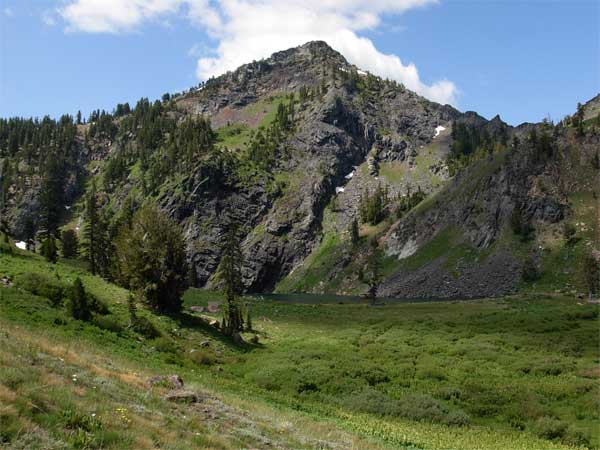
Coming to the sight of the peak, I knew
that I would summit. I was doing good! Passing Lower Wrights Lake,
I hiked by two guys camping at the upper lake. Some clouds drifted
overhead, but there was no wind. I thought that I had it in the
bag. Coming to a high ridge, there was an unsigned trail junction,
but I knew the way to the peak. I picked up my pace a bit, seeing
darker clouds starting to form, and gained the views of the distant
Scott Valley. So, Boulder Peak, the highpoint of the Marble Mountains,
seemed so close!
Doing a minor scramble, with a false summit,
from the trail, I topped out with a time of 4:41. Incredible!
The clouds added drama to my photos, validating my hoped-for different
light. I began shooting lots of photos,
and went around and around capturing the view. Glorious! I looked
at the register, placed by an Angeles
Chapter peak section associate.
The dark clouds had me rushing, so I started
down after only 28 minutes on top. I had to worry about returning
to my car safely. I continued to record
the natural features, with a nice wildflower
display, and diffuse light through the forest. Sauntering
down past the lakes, I knew as long as my legs held out, I'd be
O.K. No freak accidents, Pete.
 A
few drops of rain fell as I hiked down, but not enough to don
my rainwear for. I kept on going, thankful that I could enjoy
this magnificent area again. It was more beautiful than I remembered!
A
few drops of rain fell as I hiked down, but not enough to don
my rainwear for. I kept on going, thankful that I could enjoy
this magnificent area again. It was more beautiful than I remembered!
To my car at 4:45 p.m., I carefully motored
down the rocky dirt road, keeping track of the miles. I will have
good directions to this trailhead, a sticking point for the former
local peak section, back when they were around in the 1990's.
I made it back to Yreka, so gladly. I had
a burger and drink, and went back to my motel. I watched the TV
coverage of the Michael Jackson Memorial, which I had closely
followed on the Net, during the time of the tragic and shocking
news. I photographed a nice sunset
from my motel room.
Sleeping well enough, I woke up by about
6:20 a.m., Wednesday, this being my last day of my short peaks
jaunt. I had not recovered enough from my lack of enthusiasm,
to then realistically plan my next road trip, with maybe six peaks
to climb. So, I had to do this next peak, as this might be my
only summer adventure for this season.
Having my breakfast sandwich and diet soda,
I zoomed south on the Interstate to suffer a lapse of memory on
how to get to the trailhead. Wasting perhaps an hour wandering
about Weed, CA, I did get another drink, and was able to use the
restroom, sparing water quality in the wilderness.
Finding the right roads, I came to the
Parks Creek Pacific Crest Trail parking lot, new to me, and readied
my pack. It was still chilly this morning, so the delay wasn't
for nothing. Taking off at 8:42 a.m., I followed the PCT
south, with a savings of perhaps a thousand feet of gain as
opposed to my old way. This trail ran with a level grade, with
maybe only a total dip of 150 feet, both ways.
After an hour, I came to the Deadfall Lake
trail junction, and was pretty buoyant at my success and planning.
With a slight rest, I hiked up to the
lakes, and spoke with a young camper there. Following the now
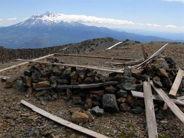
good trail to the top, I summitted at about 11:30 a.m. Nice!
I captured the views,
and drank some water. I had brought up two liters and only drank
part of it, with the cool temperatures. I used three liters the
day before. The light wasn't so great, and I placed a new register,
with my book and cans from 1983 predictably gone. It had been
similar with my register left atop Boulder Peak back in 1986.
I had thought back then that my books would be supported, but
someone doesn't like these, apparently.
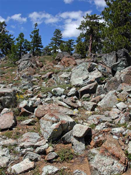
Several more hikers came up, so I left.
Even more hikers were climbing up the trail. Is peak climbing
becoming a more acceptable activity, up here? Many more hikers
were following the PCT, and I stopped for more
photos and many wildflower closeups.
I had been told by the ranger that this was a good time for that,
but I thought the display was mediocre. Well, to add to another
safe and successful hike!
Back to my car at 2:35 p.m., I changed
clothes, and set my things for the drive home. I kept more notes
on the drive to the trailhead, then was back to the Interstate.
I got some cold drink, and shortly was motoring south past Mt.
Shasta City, and then to the North Central Valley. I'd get home
fairly early to work on my computer. A bit later, I worked some
panoramas from some of the photos.
Capturing over 1,050 images, I had hiked
roughly 24 miles and climbed 8,000' gain, total. Spending some
$160 total, I drove 668 miles.
There were mosquitoes along the Boulder
Creek Trail, enough for me to apply repellant, and I used up some
old sunscreen. I wore at most an extra layer or two, with gloves
and hat with flaps. My boots did fine, and I got my usual red
eye from some motel quirk, probably the cleaning agents, or something.
I stayed loyal to my fast food preferences, and used various gas
stations to refuel, paying from 2.739 to 3.139.
This may be my month's peaks, as I have
no enthusiasm for doing this all, much again. It was great to
revisit these areas, as memory fades with time. I doubt if I'll
get any new partners, and expect, for most of the rest of this
year, to do only a few more local peaks at best. Hoping that this
summer stays mostly cool, I'll be wondering what comes next, for
me.
BACK TO PETE'S
THOUSAND PEAKS HOME PAGE