SKYLINE PARK AND SUGARLOAF PEAK
(1,630') January 22, 2006
Wishing
to hike during the dry period for these few days, I did some research
on the Net and came up with this local wilderness park. Somebody
had vaguely told me of this place, having a good vista of the
area.
 Motoring
westbound on Interstate 80, I took the CA 12 West Exit and soon
came to turn right on North Kelly Road. This eventually leads
to Imola Avenue, where I got gas at 2.239. There are a complex
of services here, with fast food and a supermarket. Imola Avenue
is a main west-east artery in the town of Napa, CA, and can be
reached from Highway 12 and 29, or any major north-south avenue.
Motoring
westbound on Interstate 80, I took the CA 12 West Exit and soon
came to turn right on North Kelly Road. This eventually leads
to Imola Avenue, where I got gas at 2.239. There are a complex
of services here, with fast food and a supermarket. Imola Avenue
is a main west-east artery in the town of Napa, CA, and can be
reached from Highway 12 and 29, or any major north-south avenue.
Imola Avenue, east, becomes a rural byway,
and shortly then comes to the signed Skyline Park. The day-use
fee is $5, taken by a live person serving in an entrance station.
I received a photocopy of the park map. I had to go back to the
entrance station attendant, and get my bearings. He pointed in
the direction of Sugarloaf Peak, which, of course, I have interest
in.
From my maps off the Net, the elevation
changes are slight. I expected an easy day, and to get home early.
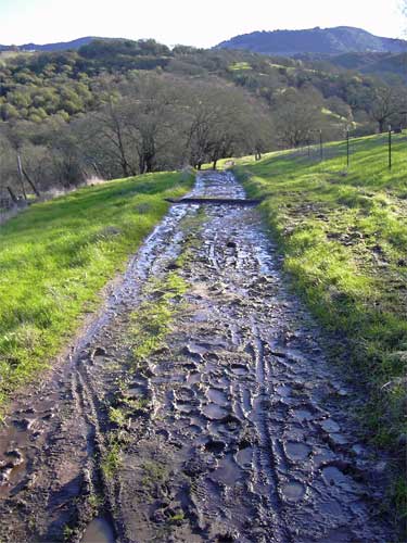
I started at about 9 a.m., on the way to the Manzanita Trail,
heading north at first. The trail was very wet and muddy (photo,
right), and many hazards for slipping currently exist on this
route. I snapped photos as record, and made my way, with big guesses
at times, to and along the Manzanita Trail. Rock walls adorn some
of the park, here, as elsewhere. The trails are poorly signed,
this way.
One trail offered a hazard with a small
mudslide, cordoned off with yellow "caution" tape. I
stumbled through, getting my fingers in mud. There are several
ups and downs, and I finally reached the "Rim Rock"
Trail, which leads to the top of Sugarloaf Peak. Some nice examples
of the geology are passed along this trail, and shortly, the trail
climbs up to the oak forested summit. Some nice views of Napa
are seen before reaching the wooded top, and I had to go back
to get some of those. I had topped out at about 11:10 a.m., a
bit over two hours hiking time.
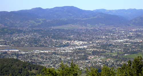
Two rock cairns along the trail mark the
supposed, nearby highpoint. A clump of moss and lichen clad rocks
under an oak tree seem to be the highest point. A hundred feet
to the west, hiking through the spongy terrain, some views (photo
below, left) of the town can be had. You can also see up the Napa
Valley to Mt. St. Helena.
Not tarrying, I continued along the trail,
southward. I gained a distant view of Mt. Diablo and the best
view, I know, of faraway San Francisco from a North Bay peak.
I had my film camera, so used up part of the roll of Kodachrome
by using my big telephoto lenses to record the silhouettes of
the highrises and the Golden Gate Bridge. All in backlight, of
course.
 The
trail descends via a few switchbacks, and shortly comes to the
Bay Ridge Trail, running along the major creek. It is dark, but
beautiful, down in the canyon, here. A few short cascades tumble
down the creek, with some red rock dispersed among the other rocks.
Puzzling to a geologist, perhaps, I recall local enviro hikers
to think it was humorous to confound scientists, them presumably
assuming no one would do that--moving rocks!
The
trail descends via a few switchbacks, and shortly comes to the
Bay Ridge Trail, running along the major creek. It is dark, but
beautiful, down in the canyon, here. A few short cascades tumble
down the creek, with some red rock dispersed among the other rocks.
Puzzling to a geologist, perhaps, I recall local enviro hikers
to think it was humorous to confound scientists, them presumably
assuming no one would do that--moving rocks!
I passed Lake Marie, a muddy sump with
a earthen dam. Seeing the first of a few hikers today, I sought
to explore a bit, taking the Skyline Trail. An overlook was promised,
though I never saw it. The junctions are better signed this way,
and I assume this part of this park gets the most use.
I got to the Passini Road, an old gravel
thru-way that made for faster hiking. People were coming up from
the bottom. My old, $25, "eco-hiker" boots, made largely
from recycled materials, began to separate. The sole of my right
boot started to come loose. I didn't have my usual repair kit,
as parachute cord or duct tape would have bound the flapping sole
back to the boot. Fine, since I would still be able to hike, as
the midsole was largely intact.
Not far from the start point, I came to
a large urban park, and figured out my way back to the parking
lot. My finish at 1:50 p.m. was a relief. These old boots coming
apart at a less opportune time could have spoiled a good day.
I supposed my hike totaled some 6.5 miles
and 1,800' gain. No mileages are posted on any sign, and on the
back of the map photocopy are some stats. The trailhead elevation
is given as "138 feet." I captured almost 150 images,
mostly "record" shots. The sun was too harsh, and there
was no diffuse light. Too dim in the trees, and too many shadows
to spoil any precise exposure.
Obtaining some fast food and drink, I then
whizzed home on the well traveling Interstate. I had spare boots,
but declined any more hiking on this fine day. This was a first
for me, so close to home. It's remarkable that primitive rec ops
are being developed in what is mostly surrounding, private, land.
This is indicated as "wilderness," in the context of
coast range lands. In largely oak woodlands, I enjoyed spotting
big mushrooms, hawks, and wild turkeys, apparently free from harvesting
or poaching.
I spotted no ticks, or mosquitoes, of course.
Signs warn of mountain lions, and wild pigs. Some trails are largely
overgrown, and use or animal trails head everywhere. No cows.
I came upon some steeper rocky sections, maybe even class 2, due
to the uncertainty about traction with the dampness. I did see
some white wildflowers, encouraging for those of us who await
the Spring.
Starting with four layers, I stripped down
to a Cap T and parka in the sun. My EW bottoms are so comfortable,
I use them often with my regular pants. It was good to have a
light cap to replace my insulated alpine cap, too.
Sadly for me, though, I count this as a
"peak." It is not much of a challenge, but I did set
standards, need the numbers, and the name says so. Recalling back
with the old chapter, some hikers "did" lesser coast
range bumps, therefore declaring three in a day, vigorously promoted
by the then peak section. With some sorrow, I complied with the
ways of the new officers, all declared as good fun by chapter
overview, but demeans so poorly the rest of us, then, doing the
big High Sierra peaks to count equally, all together, by enviro
group order of law.
BACK TO PETE'S THOUSAND
PEAKS HOME PAGE