PACIFIC NORTHWEST INNER LOOP
(continued, page 2)
Tuesday, I took Interstate 405 around Seattle,
and still got caught in a traffic jam. This took maybe an hour
extra to get through the Seattle area. Past Bellevue, WA, then,
I was headed north at good speed, again. My goal for this day
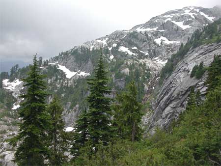
was Mt. Pilchuck. This was an easy, first peak to do. I exited
the freeway and drove eastward to pass through Granite Falls,
WA.
A side road leaves the Mountain Loop Highway, and climbs over
gravel, then pavement, to the Pilchuck Trailhead. I was a bit
concerned that a week earlier, two hikers were found murdered
along a trail in the area. Would it be a terrible end for me to
be shot by some killer?
 I started
hiking under overcast skies, and applied repellant to avoid getting
bit by the hungry mosquitoes. The trail
climbs through the typically magnificent old growth forests, and
ascends to a ridge. I could see nothing, with clouds blowing over
the peak. It took some 1:50 to get to the lookout that is built
on the peak's highest point. Other friendly hikers appeared, so
I lost my worry about being done in.
I started
hiking under overcast skies, and applied repellant to avoid getting
bit by the hungry mosquitoes. The trail
climbs through the typically magnificent old growth forests, and
ascends to a ridge. I could see nothing, with clouds blowing over
the peak. It took some 1:50 to get to the lookout that is built
on the peak's highest point. Other friendly hikers appeared, so
I lost my worry about being done in.
The clouds parted briefly to reveal some chance
sights and clear cuts, and though the views are said to be
great, I waited an hour and a half for nothing. I snapped my own
pictures, and more hikers came up. I started down after this waste
of time, because of the weather. As I hiked lower, some far distant
views of the Puget Sound and other features to the west appeared
under the clouds. The light
was poor, but I snapped away, anyway.
Back to the trailhead, two other hikers made ready for their climb.
I left to motor back down the partially paved road, and stopped
back in Granite Falls for some drink and a sandwich.
Back to the Interstate, I motored about Everett, WA, looking for
my motel, forgetting where it was. I had stayed here in 1999,
on my big Northwest Loop. I saw the town
pretty well, then. I was to lodge here for three nights.
Having a good dinner, I retired to watch the TV news. The sky
to the east had cleared, and Mt. Pilchuck was now clearly seen.
Closer to town, it stands out on the Everett eastern skyline.
After exploring the downtown section, I then motored to another
park facing the bay, and photographed the sunset.
 Wednesday
was going to be a big day, at first. I was to climb an easy peak,
then make a big driving loop crossing over the Cascade mountain
passes. But, this was not to be.
Wednesday
was going to be a big day, at first. I was to climb an easy peak,
then make a big driving loop crossing over the Cascade mountain
passes. But, this was not to be.
Liking the name, Sedro-Woolley, of this town being the gateway
to the North Cascades National Park, I stopped for a picture.
Using facilities along WA 20 before the Sauk Mountain peak road,
I found it, and was intimidated slightly by the narrow, and all
gravel, one lane road.
But, I am pretty determined. If this road became bad, I would
turn around. It was good, but steep, all the way up to the peak
trailhead. Two hikers were ahead of me.
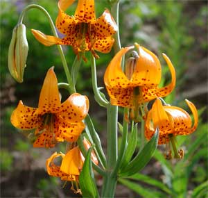
Myself starting at 9:30 a.m., this trail was a wonderland of wildflowers.
I reserved my memory for better light to be had on the way down.
It was early enough so the sun didn't yet fully hit the slopes.
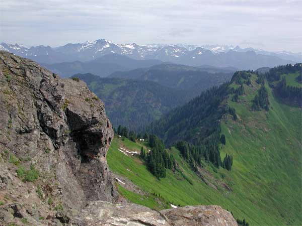
The trail switchbacks up, and the good views of the Skagit River
Valley are nice. Then I came to the main ridge. Awed by the distant
peaks, I crossed some snow. The summit of Sauk Mountain is composed
of several crags.
Alas, the trail does not go to the highest
point (5,541'). I saw that a short downclimb to a notch, then
up some low class three slopes, leads to a bump. There seemed
to be a deep notch on the other side, and I could not see how
hard it was, except that the short climb to the true highpoint
looked non-trivial. I recalled about reading that some true summit
was pretty difficult, and I had no way of knowing if this was
that one. I felt pretty timid to be trying some scrambling by
myself. I made it to the bottom of the intermediary bump, then
decided to play it really safe.
 Defeated,
I went back to the trail's end, which once was the lookout, and
began shooting photos of the still glorious view.
It was slightly overcast, with diffuse light. The peaks of the
North Cascades were quite impressive, and I can come back with
a rope and/or partner. The hike took me only about an hour to
top out, and this peak trail is said to be the biggest bang (view)
for the buck (effort).
Defeated,
I went back to the trail's end, which once was the lookout, and
began shooting photos of the still glorious view.
It was slightly overcast, with diffuse light. The peaks of the
North Cascades were quite impressive, and I can come back with
a rope and/or partner. The hike took me only about an hour to
top out, and this peak trail is said to be the biggest bang (view)
for the buck (effort).
A bit annoyed by my failure, here, I headed back down.
Now, hikers were coming up. One said it was a "scramble."
I would have turned back and gone up again, but no one was sure.
So, I could not "count" this peak. This was demoralizing.
I hiked back to the trailhead, and shortly motored back down this
steep road. I kept my car in low gear, both up and down.
Back to the main highway, WA 20, I had
taken too much time. So, I'd head back toward Everett, and see
what else to do. Managed to take a photo
of the Sedro-Woolley city sign.
A look at the map informed me of the bridge access to the islands
of Puget Sound. I could drive WA 20 onto Fidalgo Island, and see
the town of Anacortes, WA.
It proved to be interesting, and a stop at the visitor center
information was very helpful.
I motored west to Washington Park on the northwest tip of this
island. A one lane, paved road offers a short, 10 mph, driving
loop with views of the bay
and more lovely forests. This is used by walkers as well. I took
many pictures, and then headed for the highpoint of the town,
and the island, Mt. Erie.
Having my doubts about counting another
drive-up, I took the paved road to the top, and enjoyed the views of the many islands. Others were
enjoying these vistas. I wasn't to stay long, and initially planned
to do more driving down the chain of islands, and taking a ferry
back to the mainland. That'd be a nice loop.
But, I decided on going back the way I
had come, and soon was cruising south, back on Interstate 5.
 Thursday,
I would have to backtrack north on Interstate 5 to pass through
Bellingham, WA, and take Highway WA 542 to the Mt. Baker Scenic
Highway. I was in no further mood for a harder peak or hike. There
are a lot of peak trails from here, but some of them also do not
go to the true top. Church Mountain, Yellow Aster Butte, Excelsior,
Goat, Hannegan, and Table Mountain, are peaks I might wish to
try sometime. I had little idea which offered the best choice,
since the guidebooks describe all of these peak summit views with
equal superlatives.
Thursday,
I would have to backtrack north on Interstate 5 to pass through
Bellingham, WA, and take Highway WA 542 to the Mt. Baker Scenic
Highway. I was in no further mood for a harder peak or hike. There
are a lot of peak trails from here, but some of them also do not
go to the true top. Church Mountain, Yellow Aster Butte, Excelsior,
Goat, Hannegan, and Table Mountain, are peaks I might wish to
try sometime. I had little idea which offered the best choice,
since the guidebooks describe all of these peak summit views with
equal superlatives.
Motoring to the end of the plowed road,
at the Heather Meadows parking area, where there was a gate. I
took the Wild Goose Trail to save some distance. There was lots
of snow here, and they were
still plowing out the upper parking lot. I stayed out of the way
of the workmen, and crossed over firm snow along where a trail
leads in the regular summer. There is an "Artists Point,"
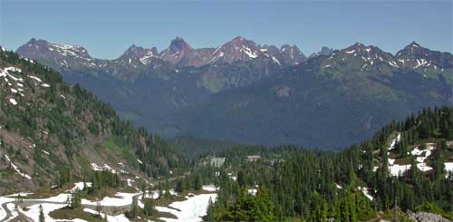
but I saw no signs indicating where it was. I snow-hiked a small
bump, with the sight of both of the two major peaks, here, Mts.
Baker and Shuksan. Classic vistas.
Getting burned from the bright sun on snow, I had only my camera
gear, with a half bottle of water, for this mile walk up the trail,
and closed road. I snapped away, and then started down. Other
hikers were coming up. I did some standing glissades, then came
back to my car.
Next, I motored back down the highway to
Nooksack Falls. It isn't recommended to risk trying to get the
more unobstructed view
of the falls, so I snapped away at what I could. Other tourists
were taking turns to shoot from the optimal spot. I managed a short movie clip (320 x 240 pixels, 475 KB, 0:06).
Back then to Bellingham, I sauntered about
the downtown section. My
information suggested to visit the nearby, historic town of Fairhaven,
WA. Photogenic old buildings, with a lively economy, had me setting
my camera to fine. An Alaska
cruise leaves from here, and I wished I could do that sometime.
I was too full from snacks to eat an early dinner, so motored
back to the Interstate, and zoomed back south to Everett.
Next
BACK TO PETE'S
THOUSAND PEAKS HOME PAGE