CLOUDS REST (9,926') 4X July
30, 2005
Gaining
interest from a local hiker, he wished to do this fine Yosemite
peak. I had done it in a day from town, a couple decades ago,
with an overweight and slow associate. I liked to see how fast
I could do it again, here years later. My new companion is quite
a bit younger, and seems good and fast. Wanting to treat him to
continue doing peak climbs, I agreed to pick him up at his home
at 5 a.m. Saturday.
 He
was ready, but a bit groggy. Many workers like to sleep on the
weekends, but he was excited to be going to Yosemite. I expected
a boring day, since I have the views on film from all my previous
ascents. Little did I know that the visibility would be the clearest
I have seen, and the summit stay one of the finest times I have
spent atop a mountain.
He
was ready, but a bit groggy. Many workers like to sleep on the
weekends, but he was excited to be going to Yosemite. I expected
a boring day, since I have the views on film from all my previous
ascents. Little did I know that the visibility would be the clearest
I have seen, and the summit stay one of the finest times I have
spent atop a mountain.
We made the drive in good time, with no
delays. Oakdale, CA, allowed for a fast breakfast stop, and the
traffic moved quickly up CA 120. I used my new Golden Eagle Passport
to enter the park, and we stopped at Olmsted Point to view our
planned summit.
Getting a parking spot at Sunrise Trailhead,
I was able to use the facility, and we began our hike at 9:32
a.m. I had warned of mosquitoes, but failed to apply repellent
till they began landing on my bare legs. This done, we hiked up
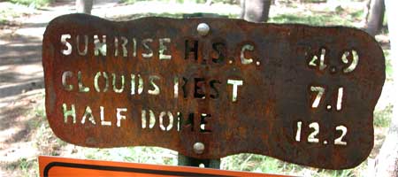
the nice trail. The trail sign indicated "7.1" miles
to the top. Passing two lady hikers, we reached a junction and
ridgetop. My memory from 18 years ago wasn't sharp, and I wondered
which way the peak was. The trail is signed pretty well, so I
had faith in the signs. I know they would be difficult to turn
in the wrong direction.
We have a total dip of about 500 feet in
this trail. Hiking downward is correct, for awhile. Then the trail
levels, and the peak comes into view. It doesn't look anything
like it does from the Tioga Pass Highway, with forests growing
up near the summit. But we followed the trail, past another signed
junction, and approached the peak. It looked like a round, rocky
bump.
I saw our time would be pretty good, despite
the heavy pack I was carrying. We summitted at 12:57 p.m., less
than 3.5 hours of hiking. I was pleased we had maintained the
average hikers' pace of 2 m.p.h. on uphill trail.
The view was the best I had ever remembered.
I took off my pack, and knew we'd be up here a long time. I'd
say maybe 50 other adventurers hiked up and by, this day, and
I enjoyed the friendly and respectful attitudes. I tried not to
disturb people enjoying the fantastic vistas, but I had to move
about to catch a better perspective.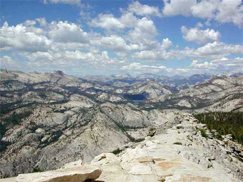
My pal and I shot away with our digital
cameras. I think I had the best quality, but others were snapping
away at the views, although not as vigorously as me. I had two
memory cards, with three batteries for the day. No problem to
click away. I did panorama shots, movie
clips, and all sorts of stills. An hour passed, and clouds, overhead,
cast shadows, changing the light. Not to brag much, but many peaks
we could see I had climbed anywhere from one to several times.
Another prominent associate in the Sierra
Peaks Section likes to complete his multiple list finishes on
this peak. Him having done all the 247 SPS peaks some five times
each, I like his taste for the culmination of these spectacular
achievements.
Hikers streamed by. Many backpackers were
climbing this peak. This was one of the most gorgeous days I have
ever seen in the Sierra.
Then I set the time to head back. I started
down at 2:45 p.m., and I figured an easy walk, mostly downhill,
back to the highway. Tenaya Lake looked pretty far, but we would
get there.
We could slow and relax more on the descent.
I snapped a few close-up photos of the remaining flowers as a
diversion, since the display was not very good. We passed a couple
lakes and ponds, and crossed a few small streams. The final bit
before the return required a rock hop across a wide, shallow creek,
with my boots again keeping my socks dry. I stepped on some slightly
submerged, shifting rocks, and guessed my clearance rack boots
had some water repellency.
Back at 6:17 p.m., after a short side trip
to the shores of Tenaya Lake, we made ready and drove off.
The mosquitoes weren't bad, but they did
land on me, even with repellant applied. I had kept walking and
brushed them off as I could, but I think I received some bites.
Not worried too much about the West Nile Virus, I had seen no
posted warnings by any government agency, here.
I drove quickly west on CA 120, getting
a power drink at the Crane Flat gas station and store. They asked
$3.00 a gallon, for regular. We chose a nice food stop back in
Oakdale, me chuckling about our excellent hike. My pal was pleased,
although tired. He agreed to hope to do some more peaks, although
I expect the next few will be easier. Home late, I began work
on my website post, after soup and more drink.
We did some 14.2 miles with 2,500 feet
gain, round trip. I captured over 350 digital images and movie
clips. I even had my film camera to use the last four frames on
a roll. Filling up in town, I returned with almost a quarter tank
(maybe 8 gallons used). The car had been driven about 365 miles,
total. I spent little, and will return to Yosemite, as I can get
a rider. I am now in fair condition, and hope to do some more
Sierra peaks. Lots of hiking season left to hike!
BACK TO PETE'S THOUSAND
PEAKS HOME PAGE