MT. ST. HELENA (4,343') 20X December
16, 2004
 Thinking of
a big road trip out to Eastern Utah, I phoned the Arches National
Park ranger to find there is now little or no snow, about the
red rock, for winter photography. No live cams to check. Thus,
I'd spend probably $500 just to hike the trails I haven't done
already, and mostly see the same old sights again.
Thinking of
a big road trip out to Eastern Utah, I phoned the Arches National
Park ranger to find there is now little or no snow, about the
red rock, for winter photography. No live cams to check. Thus,
I'd spend probably $500 just to hike the trails I haven't done
already, and mostly see the same old sights again.
So, to delay the trip for a time when there
is new snow and then sunny weather, I figured on doing a local
few peaks and hikes. My plan was to climb Mt. St. Helena, then
lodge in Ukiah, CA. Then, I'd drive to Russian Gulch State Park
to do a few trails said to be good and easy. I might have the
time to do other trails, or just enjoy the coastal drive, again.
This wouldn't cost too much.
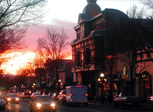
Not able to sleep again, I left home by
about 4 a.m. to have a good breakfast along I-80. Taking CA 29
north, I stopped to catch the sunrise (photo, right) in the town
of St. Helena, CA. This is an upscale, trendy town, with many
window fronts nicely decorated
for the holidays.
Motoring on to Calistoga, I walked about
to snap more photos.
Then it was time to do the peak. I started
from an empty parking area at about 8:30 a.m. I saw a banana slug
on the dirt trail, and noted some new posts indicating the distances
to the north peak, the highest one. Low clouds lay over the northern
Napa Valley, and I snapped many a photo
(below). It was cold and windy, so I wore four layers. The sun
was out, above, but fog lay over much of the distant landscape.
I decided later that the coast might be covered in clouds, when
I got there, as I could see, so opted to cancel that plan.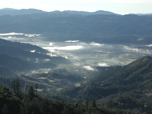
I looked for ten minutes, but failed to
find the register for the East Summit, or the now signed, "mid
peak." This is the high point of Napa County. Descending
back to the main dirt road, I ran into another hiker. We talked
about peaks, and hikes, and we both summited at about 11:25 a.m.,
some three hours total time for me. Slow. But I was carrying my
23 pound day pack.
The Sierra was clearly seen above the Central
Valley fog, and the ocean was covered in low clouds. I hoped for
a clear enough view today to
maybe spot Mt. Shasta, but only Lassen Peak, as usual, was seen.
It appears that much of the snow from past storms had disappeared.
Snow Mountain looked bare.
We both headed down at Noon, encountering
a few more hikers coming up. Nobody was climbing at Bubble Rock.
I took a few drink and rest breaks, then came back to my car by
2 p.m.
The hike is signed as 10 miles round trip,
with some 2,400' gain. I use a road switchback shortcut just before
the final stretch to the top.
I stopped at a bakery in Calistoga to refresh
myself, and snapped a few more pictures with afternoon sun. I
shot over 200 images. Nothing for movies. My total cash spent
was a bit over $30 total. Plenty of fuel left in my tank. Better
to save up, plan, and wait for a more spectacular, winter, Utah
and Vegas road trip, maybe.
BACK TO PETE'S
THOUSAND PEAKS HOME PAGE