FISKE (2,868') 9X December 19, 2004
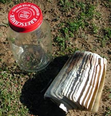
Rather than mope about in the dense valley fog, I chose to go climb a peak and fulfill a mission. I received an e-mail telling me that the glass jar register container on Fiske was broken, and the contents would then be exposed to the elements. Declining, initially, to do anything, I knew first, it might be a bogus report, and then, I subject myself to some hazard doing this rough trail. I opted then, though, to get out of the Valley pea soup.
Despite having no partners, I headed out
from the Lower Site of the Cache Creek Canyon Regional Park by
about 11:20 a.m. The low water bridge was fine, and I clambered
up onto the dirt road leading to the signed, trailhead start.
After the first few hundred yards, I noted mushrooms sprouting
in the dank, dark forest. When I returned from this hike, many
more varied mushrooms had popped up. Don't ever try to eat any
of these--some 50% of species are poisonous. Even experts can't
tell! This made for a close-up photo shoot, later this day, for
me.
The trail was generally damp, as expected, but rarely mud. Only a few, footlong sections presented any slipping hazard. I made good time with my heavy day pack along the hillside, enjoying the green grassy slopes and the red berries of the toyon. Much of the trail is in shadow, so it was a bit chilly. I wore two layers most all day, except adding a layer on the way down.
Rounding the ridge corner, I looked down on the highway 16 bridge. I stopped for a quick drink. The rough trail winds to the south and then up. It climbs up to the main Blue Ridge. I was mildly surprised to see the burned area, here, from the summer's Rumsey fire. I didn't think the fire made it up here. The ridgetop and much of the lower slopes were devastated by the fire. Only dead branches of the shrubbery, blackened and leafless, remained.
The trail winds nicely through what was thick chapparal, and the open aspect provided better views of the geology. Many rocks weren't scorched, and it is all a plan of nature that fires do occur in this ecology. I soon approached the summit, expecting to see other hikers.
Topping out at 1:28 p.m., I found the register, and, lo, the glass jar was broken as they said. The book inside was scorched a bit, but still signable. I collected the broken glass and prepared a new book, since the old one was nearly full. I brought up another glass jar, which makes a tight fit for two books, but will have to do. I am too poor to use anything else but recycled cans or jars for containers. Maybe someday, someone will bring up an ammo box!
I enjoyed the bright sun, and distinctly
saw Mt. Shasta to the far north. This was the clearest I had ever
seen, from up here. Fog lay over the distant Central Valley, but
the Capay Valley was clear.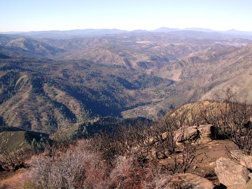 Sutter Buttes and Lassen Peak made for telephoto shots.
After about an hour on top, I had to go. I noted trail erosion, and liked the green stems regenerating in the burnt soil and missed places. This sure made my day! In decades, it will be mostly grown back, but I'm sure I will be enjoying this hike many times before. An upside to this fire is that the food garbage that other hikers had tossed into the brush would have been incinerated. Club trips.
Eager to see other hikers, none appeared. I sauntered on down, and was back to my car by 4:07 p.m.
The fog had lifted at about Esparto on the way up, and had crept up to Capay on my return. I had to slow to about 45 mph to be safe, and then on the Interstate, sped up to 65. Dense at spots, this had scared away a former companion from enjoying a most beautiful day!
The stats are 8 miles and 2,300' gain, round trip. I shot about 200 images. I spent only for an iced tea at the Cache Creek Casino mini-mart.
If not going to Utah any time soon, more coastal range hiking seems to be the ticket to wild fun. With the "Pacific High," maybe a more northerly destination will be good to do!
BACK TO PETE'S THOUSAND PEAKS HOME PAGE