 A 23
mile rim drive brings one past majestic views,
and the grandeur was amplified by the snow covered hills to the
distant north. I made a point of stopping at every signed vista.
A 23
mile rim drive brings one past majestic views,
and the grandeur was amplified by the snow covered hills to the
distant north. I made a point of stopping at every signed vista.WINTER 2002 SOUTHWEST LOOP
CONTINUED:
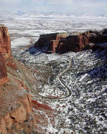
Grand Junction, CO, is a big town. The
sun and blue sky came out here, so after speaking with an Interstate
information worker, I drove the short distance into Colorado National
Monument. A 23
mile rim drive brings one past majestic views,
and the grandeur was amplified by the snow covered hills to the
distant north. I made a point of stopping at every signed vista.
The Welcome Center help had advised me to stop and turn around maybe halfway into the loop, but the rangers assured me it was all worth seeing. I finished the drive, looped back into town, and then headed west again on Interstate 70.
Passing through Crescent Junction, then Green River, UT, I had to choose whether to re-visit Arches and Canyonlands National Parks. The afternoon light was beautiful, so I opted to continue west and see the magnificent San Rafael Swell. This is an area not yet designated park or wilderness, but a bill in Congress seeks to change that. There are some 4 or 5 vista points along the freeway, and I took them all. My telephoto lens comes in handy for the distant features.
The sun was setting to the cloudy west, the light was glowing orange, and the shadows were stretching over the peaks and pinnacles. This is one of my favorite moments for photography.
Driving over the mountain pass through the Fishlake National Forest, I came to a bit of snow falling, but it didn't last. I exited to check Salina, UT, but chose to motor on into Richfield, UT, for even more cheap lodging and a great meal.
Running low on cash, and having charged up a $200+ bill for the six straight nights spent in more comfort (the nightly lows dipped into teens and single-digits), I thought to head for home. I certainly plan to be back. The fall colors in the San Juans will be the best I will have ever seen, and the Gunnison River's Black Canyon has interested me for a long time. Some 14,000 foot peaks also await.
I began my final 720 mile day drive home taking U.S. 50 west. Passing the snow clad red rock mountains of the Pavant Range, I motored through the small desert towns like Scipio and Delta, UT.
My guidebook gave precise directions on the side trip to the site of the Topaz internment camp. Some nine thousand, mostly Americans of Japanese descent, were held here during WWII. Only a vandalized monument remains.
Called the "Loneliest Highway,"
I find U.S. 50 to be my driving favorite. The peaks and hills
are so beautiful, and I have always wished to make a winter trip
to the central and east Great Basin. 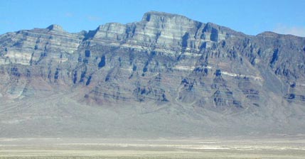 Distinctive
Notch Peak (9,655') is seen on the entire drive from Utah's I-15.
An easier peak climb to do, I wait longingly for a partner that
will climb one peak "not on the list." I shot many pictures in anticipation.
Distinctive
Notch Peak (9,655') is seen on the entire drive from Utah's I-15.
An easier peak climb to do, I wait longingly for a partner that
will climb one peak "not on the list." I shot many pictures in anticipation.
From about the vicinity of Baker, NV, I have already seen it all, westward. Signs, even back in Utah, invite one to come to the National Park here. Wheeler Peak was decked in snow, and so were Mt. Moriah and Ibapah Peak. I have always wondered about a ski tour here, but as with most of Nevada, there isn't enough snow to be reliable.
Near Robinson Summit, tracks from snowmobiles looped across the snow. Then, Diamond Peak had a smooth covering of white. I drove at 65 mph, as I could, figuring on making it home this day. I stopped at several points for more peak photos, and finished my photography with a vista of alpenglow on the Toiyabe Range.
Driving through Fallon, NV, then Reno, I saw my trip to finish on a good note.
I had shot almost 1,700 digital images and movie clips (963 KB, 0:23, 320 x 240 pixels), along with 8 rolls of Kodachrome. I hiked some 40 miles with some 12,000' gain, total. I had driven almost 3,000 miles, with an average fuel efficiency of some 41 miles to the gallon.
BACK TO PETE'S THOUSAND PEAKS HOME PAGE