 Coming
to the upper reaches of the bike trail, I headed back westward.
Passing parts of the State Park system, I witnessed some geese
feeding, on the grassy lawn.
Coming
to the upper reaches of the bike trail, I headed back westward.
Passing parts of the State Park system, I witnessed some geese
feeding, on the grassy lawn.LAKE NATOMA LOOP January 29, 2006
Mindful of the weather, I sought to do a local hike on this gloomy Sunday. Using RT Metro, I rode out to the end of the line in Folsom, CA, and enjoyed this visit, my second by light rail. Starting at about Noon, I toured the main historic street, and then headed upstream for the old truss bridge crossing the American River.
Coming
to the upper reaches of the bike trail, I headed back westward.
Passing parts of the State Park system, I witnessed some geese
feeding, on the grassy lawn.
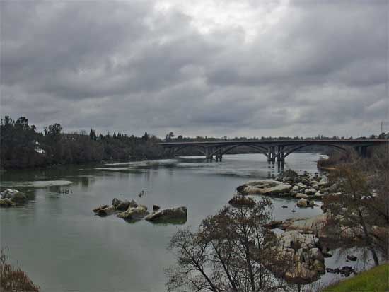
The bike trail traverses the narrow, northern shore of Lake Natoma, where the water level stays about the same. Large bluffs have sluffed wet dirt across the bike trail. Many signs interpreted the natural history.
The trail was too narrow to accommodate the many users, seeming to converge at some places, with cyclists, walkers, and joggers, forcing me out onto the sandy, but damp, and sometimes muddy, or even non-existent shoulder. No rules state to use the left shoulder out here, and often there is little or no room for more than two cyclists riding side by side.
Soon, the bike trail leaves the lakeshore, and I hiked at a good pace. Plenty of users, even on this cloudy day. I feared for some rain, but the forecasters had said it would be a nicer day. I liked taking pictures of the dark clouds, with the sun breaking through at times.
Passing the low dam, I soon was walking south over the river on the Hazel Avenue Bridge. Looking for some poppies, I walked westward on the bike trail to where, usually, the Department of Fish and Game operation maybe grows some. No flowers.
I walked back east to Hazel Avenue, then headed south on the short, undeveloped side of the busy road, and obtained a badly wanted drink at a fast food restaurant. About 3 p.m., I knew I had plenty of time.
The sky looked a bit better, and I decided to continue along and around Lake Natoma. The bike trail circles the lake, and I have never walked some of this fairly new trail. Going west to Fair Oaks would have cost me 25 cents for a bus transfer, even though it was a shorter distance, from Hazel Avenue, to complete a hike.
Along the southeast side of the lake, one bike trail crosses over the freeway, U.S. 50, and shortly ends, but I knew what trail fork (left) to take. The signs here can be misleading.
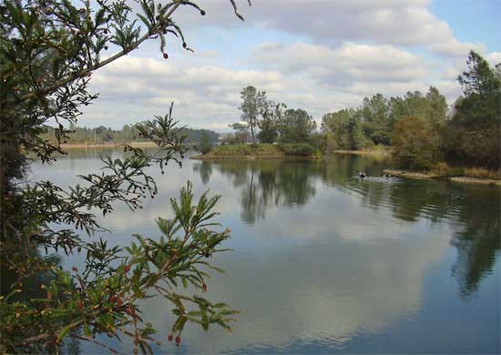 A
sandy foot trail parallels the paved bike trail, and I took it
when I could, with its better view of the lake, and nature. A
coastal range redwood even graces the trail at one point. Two
kayakers paddled along the serene lake. Blue herons nest in the
area, and I enjoyed the large oaks that grew along the lake shore.
A
sandy foot trail parallels the paved bike trail, and I took it
when I could, with its better view of the lake, and nature. A
coastal range redwood even graces the trail at one point. Two
kayakers paddled along the serene lake. Blue herons nest in the
area, and I enjoyed the large oaks that grew along the lake shore.
The dredge tailings made for more historic interest, and I shot even more photos. Speaking with some dog walkers, I found that it then wasn't much further to the light rail station. There are a few bailout points, if the hike gets to be too long. Glenn and Iron Point Stations are easily reached via side trails.
Soon coming to a fork, I took the upper right trail to shortly arrive back at my start, to have completed this loop. The public restrooms were closed, and no fast food restaurants are here to provide some cheaper food and drink, too.
The train came by, on time, and I used my ticket. It was 5 p.m. There not being many riders, some people had bikes with them. They are allowed on the train.
I'd say my walk totaled 12 miles, with negligible gain. I shot almost 150 images. I spent only about a dollar for the soda drink, then $1.75 each way for the longest train ride possible, from downtown, for the light rail system.
Having my light pack, with extra camera gear, I wore four layers to start. Nice to have a light cap, when my insulated cap overheats my head. Comfortable in my EW bottoms, I kept my better boots cleaner, by sticking to pavement, or avoiding the muddy patches, as best I could.
I had figured on dining at a nice restaurant out here in Folsom, but I heard of two accidents involving light rail in the last week or two. The train serves Folsom only till about 7 p.m. Better to get home early. I kept my activities to all mainly non-fossil fuel use (as opposed to driving cars), for this local hike.
BACK TO PETE'S THOUSAND PEAKS HOME PAGE