SNOW CREEK TRAIL, YOSEMITE February
6, 2000
The
initial plan was to ski to the Crane Flat Lookout (6,644') from
Highway 120, a short tour. I had skied up to this point in a blizzard
two years ago, and never witnessed the view. However, today, on
our arrival, there appeared only a few inches of old snow with
stretches of dry pavement. Around us, entire hillsides of forests
were completely snowless.
 Our
plans were changed to visit the Valley floor, and possibly go
for a hike. Asking for ideas at the Park Service Information Center,
we were told that the trail up Snow Creek was clear to a point,
as on other trails on the south-facing valley walls.
Our
plans were changed to visit the Valley floor, and possibly go
for a hike. Asking for ideas at the Park Service Information Center,
we were told that the trail up Snow Creek was clear to a point,
as on other trails on the south-facing valley walls.
We drove to the Stables parking lot, and
began hiking at 11:45 a.m. Closed roads led us to Mirror Lake,
where we enjoyed the tranquil waters, and the reflection of snowy-capped
domes to the east. The lake waters were low, and the water a rusty
color. This was not the glorious photo op that I remembered in
years past. However, the trail continues up canyon to a junction
with signs and mileages.
The Snow Creek Trail climbs in elevation
from about 4,000 feet to well over 6,600 feet where I stopped.
The trail was dry and clear of snow to this locale. Some small
patches of snow on the trail marked my highpoint. I could have
gone further, but there was a time constraint. I had set my turn-around
at 3 p.m., due to concerns about darkness.
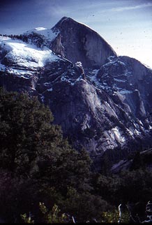
I had taken plenty of photographs
of the massive formations across the canyon. Half Dome (8,842')
made a great subject, with its 2,000 foot vertical Northwest Face,
etched with ledges covered with snow. Clouds Rest (9,926') was
more solidly covered, and made a more typical winter sight. These
were vantages which are not seen by most tourists. While the trail
is very good, there are many switchbacks to accomodate the steep
terrain, and there is no distinct, day-hike goal to be reached.
The trail eventually goes to Tenaya Lake on Highway 120, or, also
in many miles, to North Dome.
I rejoined my slower companion, and we
methodically plodded down the trail to return to Mirror Lake,
where we ran into other hikers. Pale evening light cast itself
on the great Northwest Face of Half Dome high above us. We took
a wrong turn on the roads, and came to a nice view of North Dome
with orange sunset light over the Merced River. We came back to
our vehicle at 5:36 p.m., just before complete darkness.
Our drive home was made under the stars,
with a sliver crescent moon in the low western sky. Traffic was
almost non-existent, although I watched my speed due to the chance
of wild animals standing on or crossing the road.
My distance hiked was about 11 miles total.
It is 2.4 miles one-way to Mirror Lake, all of which is flat or
small hills. I believe I reached at least 6,600 feet elevation,
looking at the topo map later. I could see the top "obelisk"
of Mt. Clark from where I turned back.
The snows in the Northern Sierra had now
been heavy to this point in time, but very little of the precipitation
had yet extended southward to this part of Yosemite, at this date.
A snow depth report of 3.5 feet at Badger Pass ski area led me
to believe that we would have enough snow to ski at Crane Flat.
Most years, in February, that would be the case.
BACK TO PETE'S
THOUSAND PEAKS HOME PAGE