RALSTON PEAK (9,235') 19X AND
GENOA PEAK (9,150') 4X, WITH A RENO EVENING HIKE June 14-15, 2000
 Motivated by the hot temperatures forecast about
most of California for these two days, I began a mid-week peak
hike from Echo Lakes Trailhead at 9:36 a.m. The gain to the summit
of Ralston Peak is relatively slight, about 2,000 feet, with mainly
a long walk along the two lakes. A water taxi, with a posted fare
as $7 each way, was available for those that wished to save the
reported 3.5 miles (round trip?) of hiking.
Motivated by the hot temperatures forecast about
most of California for these two days, I began a mid-week peak
hike from Echo Lakes Trailhead at 9:36 a.m. The gain to the summit
of Ralston Peak is relatively slight, about 2,000 feet, with mainly
a long walk along the two lakes. A water taxi, with a posted fare
as $7 each way, was available for those that wished to save the
reported 3.5 miles (round trip?) of hiking.
It took me about an hour to hike the distance
along the lakes. I saw snow ahead along the route of the Pinecrest
trail on the side ridge. Trying something new, I took the signed,
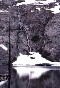
sometimes indistinct, side trail to Tamarack Lake. Two
small waterfalls graced the far side of one lake.
I made two creek crossings, by then mostly
cross-country, hopping on logs and rocks, to get to the base of
the northeast rib that leads to the top of Ralston Peak. This
rock rib turned out to be only a class 2 scramble with some steeper
snowfields, beforehand, to climb. I used my old ice axe, and kicked
steps in the firm snow.
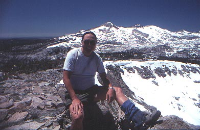 Summiting
at 1:26 p.m., I knew my time was slow. I had spent time looking
for the easiest or most expedient route, with more time kicking
steps in the snow. Also, it was warm. The highs today in the Central
Valley were to be about 107. The heat saps my strength.
Summiting
at 1:26 p.m., I knew my time was slow. I had spent time looking
for the easiest or most expedient route, with more time kicking
steps in the snow. Also, it was warm. The highs today in the Central
Valley were to be about 107. The heat saps my strength.
The summit view
was revealing. The Lake Aloha basin had 50% snow coverage. The
south-facing slopes on Dicks and Jacks Peaks, and Mt. Tallac,
were mostly bare. But, almost solid snow covered the eastnortheast
slopes of the Crystal Range.
I had seen another lone hiker descending
as I made the top. Another trail ascends the now mostly, snow-free,
south side of this peak from near Camp Sacramento, on U.S. 50.
After a good rest, and plenty of photos, I started down at 2:17
p.m. Taking the route of the Pinecrest Trail northeast, I had
a fun time doing standing glissades, and navigating along on snow
while looking for the trail. I eventually came to the trail junction,
with a post, near Haypress Meadows, then started back to Echo
Lakes.
This portion of the Pacific Crest Trail
is rocky and rough, with water flowing down the trail. As one
leaves the designated wilderness, the footing, and the trail,
gets better. I came back to my car at 5:30 p.m.
Having a buffet dinner and comfortable,
inexpensive, mid-week lodging in South Lake Tahoe, I watched TV
till late in the evening.
After a satisfying restaurant breakfast
Thursday morning, with lots of coffee, I drove east on U.S. 50
to the Kingsbury Grade Highway, NV 207, and took the side road
to Brautovich Park. The paved road, Andria Drive, continues to
the signed North Kingsbury Trailhead
for the Tahoe Rim Trail.
It is possible to continue driving up the
main dirt road that leads to Genoa Peak. At this time, road work
was being done, and then presumably, a regular passenger car,
with a good driver, should be able to drive most of the way to
the peak. Only on the steep, rocky, last half-mile or so, up the
peak massif, would a 4WD vehicle be required.
I chose to hike the Tahoe Rim Trail, which
is listed as six miles, this way, to the top. It is used also
by mountain bikers, and winds through pine and red fir forest.
It drops and climbs some 300 feet total, then ascends further,
in 4.3 miles, to a flat area and a posted junction with a dirt
road. Continue up on dirt roads. The last 150 feet are on rocky
use trail. My total ascent time, from the TRT Trailhead, was three
hours and six minutes, but this accounts for a wrong road taken
with cross-country hiking to get back on route.
The vista of the Carson Valley includes
fine views of both Carson City and
Minden/Gardnerville. A nice view of Lake Tahoe has the higher,
western peaks covered yet with snow.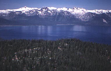
My fast hike back on the main dirt road,
to my car at the North Kingsbury Trailhead, took one hour and
forty eight minutes, with quick stops, and then, notes taken.
My warm, mid-afternoon drive north up U.S.
395 to Reno wasn't too bad. I took a couple ice soda drinks before
coming to the meeting place, on the lower slopes of Peavine Peak,
for the 6 p.m. Great Basin Group evening hike.
Some dozen evening hikers were taken up
Evans Creek, with a cool, pleasant trail that climbs so gradually
to a vista point of 395 north. We climbed back left into and up
the mountain, and came to crags with
a good view of downtown Reno. A rock ring campsite, along with
a memorial plaque, made stops of interest.
The sun sank low on the western horizon,
and the nearly full moon appeared to the east. The hills turned
orange from the alpenglow, and the lights of downtown turned on.
We spent magic hour descending back to the Basque Monument and
then to the car parking lot at Rancho San Rafael Park.
This last one was another enjoyable hike
offered free, as most of their local activities, by the Sierra
Club. I had hiked about 25 miles with 5,000 feet gain, total,
for my own two-day trip.
I mainly just needed a polyester T, organic
cotton cap, and nylon shorts for my hiking. Of course, I always
carry plenty of warm clothes, and rainwear, stuffed in my climbing
pack, in event of problems. On Ralston Peak, my socks and regular
nylon hiking boots became wet from the snow tromping, but that
just helped to make me cooler, this day. I did use an old pair
of gaitors. And yes, SPF 50 sunscreen was indispensable. Be sure
to always wear UV-blocking dark glasses, since you can lose 15%
of your vision from high-altitude snowblindness just in an hour
or so.
BACK TO PETE'S
THOUSAND PEAKS HOME PAGE