LEAVITT PEAK (11,569'), STANISLAUS
PEAK (11,233'), AND BLACKHAWK MOUNTAIN (10,348') September 9-11,
2000
 Meeting at Sonora Pass at 8 a.m. Saturday, I joined
this weeklong SPS trip to the Northern Sierra. Enroute, I had
shot a picture of snowy Round Top, then
the largest Sierra wave formation I have seen. Also, some of the
other peaks had gotten some new snow a few days ago.
Meeting at Sonora Pass at 8 a.m. Saturday, I joined
this weeklong SPS trip to the Northern Sierra. Enroute, I had
shot a picture of snowy Round Top, then
the largest Sierra wave formation I have seen. Also, some of the
other peaks had gotten some new snow a few days ago.
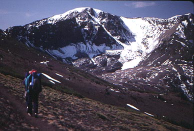
We started at 8:50 a.m. to take the Pacific
Crest Trail south to the east slopes of Leavitt Peak. I topped
out at 12:23 p.m. The views
were good, with Lyell, Banner, and Ritter visible to the south.
We ten signed in the register, then headed back the same way.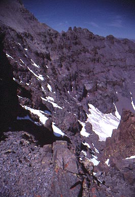
Some red color showed itself in the cliffs
below the peak.
Also, a still icy lake was spotted below
to the east of the crest.
We found a primitive car campsite a mile
or two east along Highway 108. We had a campfire, and relaxed.
This night was a bit chilly for me.
Going back west along Highway 108 the next
day to the St. Mary's Pass Trailhead, we started at 8:30 a.m.
to climb to the pass, and then contour on a use trail to Stanislaus
Peak. We encountered three other peak climbers from the south
Bay Area. Trying to induce others to see the vertical granite
chutes and snowfield, below, to the east, I climbed up there to
advise the group on the route
up the final 700' climb. I summited at 11:33 a.m.
After a short stay, we downclimbed the
short class 2 south cliff, and then declined to bag nearby Sonora
Peak.
Motoring west down Highway 108 to Kennedy
Meadows, we secured a campsite. The others dined well, I hear,
in the resort restaurant.
Only three of us started at 7:13 a.m.,
Monday, for our long, one day climb of Blackhawk Mountain. I remembered
very little from a backpack in 1982. The trail first ascends through
a spectacular gorge, with a high
bridge. 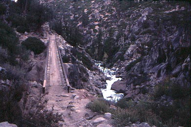 I
unknowingly got ahead of the others, so we wondered for a bit
where we all were. I waited at a trail junction, then the other
two came by. We made good time up the trail, on which I had gone
the other way in 1972, while doing the complete Tahoe-Yosemite
Trail, 186 miles long.
I
unknowingly got ahead of the others, so we wondered for a bit
where we all were. I waited at a trail junction, then the other
two came by. We made good time up the trail, on which I had gone
the other way in 1972, while doing the complete Tahoe-Yosemite
Trail, 186 miles long.
Coming to Lunch Meadow, we headed cross-country
to a granite ridge that leads southwest to the top. We became
separated again, but all regrouped on the summit at 1:43 p.m.
The views were clear and gorgeous. I took a lot of pictures.
The registers were interesting. Only real Sierra Club peak baggers
would go all this way to do this peak.
We left the top at 2:09 p.m. to try a more
direct route back. Going north,
connecting up with a few lake chains, Blackhawk and Lewis Lakes,
we regained the trail about two or two and a half miles down from
where we initially left it on our ascent.
The sandy trail went quickly for us, and
we took brief breaks together to enjoy the late afternoon. I was
back to my car at 7:35 p.m., about dark. This was a 22 mile, 4,800'
gain round trip. Badly needing a shower and food, I left the group
to drive west to Sonora (60 miles) and then home. My plan was
to rejoin the group later in the week.
My total stats were some 40 miles hiked,
with 9,400' gain.
I considered doing Blackhawk Mountain,
taking notes, a coup for my peaks guide. This was the last SPS
listed peak whose route description wasn't, till now, officially
addressed in a guidebook.
BACK TO PETE'S
THOUSAND PEAKS HOME PAGE