DEADWOOD HIKE
March 26, 2000
For
our fourth time to do so, Rex and I completed this good conditioner
hike about the area of Michigan Bluff, along the Foresthill Divide.
This area is located about 15 miles eastnortheast of Auburn, CA.
 Checking
the USFS ranger station in Foresthill, it is open from 7:30 to
4:30 Monday through Friday. They usually have good information
on the roads and trails. We sought to find a place for a rest
and food. The old Foresthill Lodge is now the Forest House, with
marvelous improvements. The interior was redone, and there is
an outside patio deck for dining, with a view to the south into
the canyon of the Middle Fork of the American River.
Checking
the USFS ranger station in Foresthill, it is open from 7:30 to
4:30 Monday through Friday. They usually have good information
on the roads and trails. We sought to find a place for a rest
and food. The old Foresthill Lodge is now the Forest House, with
marvelous improvements. The interior was redone, and there is
an outside patio deck for dining, with a view to the south into
the canyon of the Middle Fork of the American River.
We had a light breakfast, and drink, then
motored to Michigan Bluff where our hike begins. A road, to the
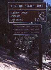
dirt parking lot, at the end of the main street is signed. This
is an access point to the route of the Western States Trail, which
is a 100 mile trail from The Olympic Village to Auburn. In June, a foot
race is conducted whereby entrants attempt to run the entire distance
in under 24 hours. We perhaps saw a few runners training for this
grueling event.
Starting our hike at about 10:45 a.m.,
the trail, signed well, descends
to El Dorado Creek hiker bridge. Then a signed junction is taken
left to go to the site of the old town of Deadwood. The other
trail right goes to Bake Oven, a site on the North Fork of the
Middle Fork of the American. The Deadwood trail climbs and switchbacks
upward, then levels slightly as it approaches the site.
Some modest views are gained as one hikes
up on this trail. Passing through stands of pines and firs, one
comes to a road where motorized vehicles are allowed in from the
north. A gate marks the entrance to a cemetary for some of a pioneer
family. This is at the top of a forested hill, but we don't count
it as a peak. We arrived here at 2:23 p.m.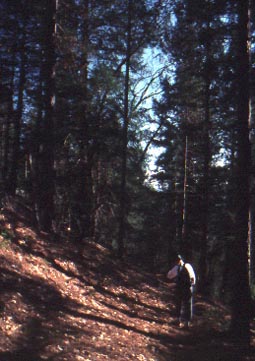
Leaving here at about 3 p.m., we hiked
back down to the El Dorado Creek bridge, taking plenty of rests.
It had been a warmer day. I was in T-shirt and shorts. From the
bridge, we climbed up the big hill to arrive back to the car at
6:05 p.m. Despite the trim looks of other hikers, we didn't see
anyone else complete the hike all the way to Deadwood.
This hike is now signed at 6 miles one-way.
I heard that the total round trip gain is 4,000 feet vertical.
We saw some slight clusters of shooting star flowers, and baby
blue eyes. This is not much of a flower hike. Reports say Mt.
Diablo in the Coast Range, and the Stevens Trail near Colfax on
I-80, have much better displays currently.
We had been concerned about ticks and rattlesnakes.
We didn't see any.
There are many canyon hikes to do in this
general area. All of the trails are fairly steep, and every hike
is started first going downhill. There have been problems with
exhausted hikers unable to climb back out of the canyon. One should
be certain of your ability to complete the vertical gain, often
thousands of feet. When the hiking isn't during the months of
summer heat, it can get cold at night. And as always, aerial rescue
would be hazardous and very expensive.
BACK TO PETE'S
THOUSAND PEAKS HOME PAGE