COLD CANYON/BLUE RIDGE LOOP February
9, 2003
 Apprised by
the fine website, yolohiker.org, I learned of this recently built
trail only a short way from home. Wishing a good Sunday afternoon
jaunt, I motored through Davis, then Winters, CA, and onto Highway
128. It was almost 1 p.m. when I started up this trail. Many cars
were at the trailhead parking, but the only facilities were back
at a private resort.
Apprised by
the fine website, yolohiker.org, I learned of this recently built
trail only a short way from home. Wishing a good Sunday afternoon
jaunt, I motored through Davis, then Winters, CA, and onto Highway
128. It was almost 1 p.m. when I started up this trail. Many cars
were at the trailhead parking, but the only facilities were back
at a private resort.
Plenty of hikers were seen here today.
The area is a nature preserve, run by the University of California,
Davis. The trail was damp in the canyon, with short sections of
muddy spots. I saw no flowers at first. The creek was flowing
well, with clear water down smooth rocks. I came to the homestead
ruins after a half hour, and then the new section of trail continues.
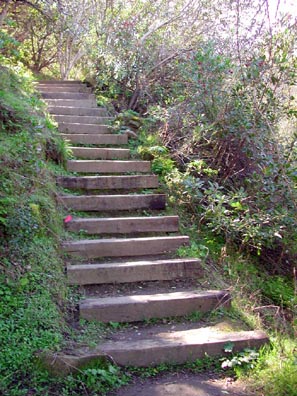
More wooden stairs sped me up the steep,
brushy hillside. I had to strip out of my third layer. This trail
is similar to the other Blue Ridge hike, to Fiske, with steep
and winding turns. But I knew that not much hiking is needed to
gain this ridge.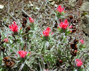
On top of what is Blue Ridge's southern
extension, the sun was bright. The trail goes right over a couple
bumps. I ran into other hikers, and wished that this ridge was
higher.
The high point of the hike is a local summit,
at some 1,580+ feet elevation. My summit time was some 80 minutes.
But, with no benchmark or name by the maps, I will decline to
"count" it as a peak. Mt. Vaca (2,819') overshadows
everything here. I took some time resting near some views a few
yards north of the summit's highest rocks. I declined to place
any register, although I'm sure people would enjoy it. Maybe another
trip.
Lake Berryessa is right below to the northwest,
making the main feature seen from the top and along most of this
ridge trail. I could see the Crystal Range of the Sierra Nevada,
and part of the Central Valley.
In an pleasant fashion, the trail heads
north along the top of the ridge. Up here, the trail was baked
dry. Some hands-on scrambling is actually needed! There is another
bump the trail runs over the top of, and more views of Lake Berryessa
are gained. 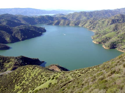 There is a lower rock outcrop, with a side use trail, that has
a view down to the dam.
There is a lower rock outcrop, with a side use trail, that has
a view down to the dam.
Some sections downward from here are steep,
with erosion wiping out the middle of the trail. This part is
relatively short, though, and soon easy hiking downward brings
one back to the bottom of the canyon, and shortly back to the
highway. An inverted truck marked someone's attempt to drive up
the now gated dirt road a short way.
Back to the car at 3:45 p.m., I chose not
to climb up another side trail for more conditioning. I recall
doing that side trail a while ago, anyway.
After a good drink of water, I motored
east back to Winters, CA, where I strolled
about the historic section and snapped a few more photos. There
are no fast food services, so I didn't get any drink or food.
Using Russell Boulevard going back to Davis,
I wished to someday try the bike and running trail that runs along
the street. It goes quite the ways out of town.
The loop is given as 4 miles, 1,500' gain.
Seeing no ticks, I saw some poison oak sprouting. I shot about
125 digital images. My motoring used less than a quarter tank
of gas. This is a fine workout hike, but the trail is reported
to get slippery with rain. I took this trail today as there has
been a long dry period here in this supposed El Nino winter! And,
spring is coming!
BACK TO PETE'S THOUSAND
PEAKS HOME PAGE