EL DORADO TRAIL 2X AND THE COSUMNES
RIVER PRESERVE November 18-19, 2003
 Taking advantage
of the fine weather between the storms, I motored, on Tuesday,
in the afternoon to Placerville, CA. I wished to check out the
lingering fall colors on this relatively new bike trail. Exit
off U.S. 50 on Mosquito Road, or take Broadway exit and drive
back west to get to this road. A short way north is Placerville
Station, with facilities and a bus stop. I parked here, and began
my 6 mile walk.
Taking advantage
of the fine weather between the storms, I motored, on Tuesday,
in the afternoon to Placerville, CA. I wished to check out the
lingering fall colors on this relatively new bike trail. Exit
off U.S. 50 on Mosquito Road, or take Broadway exit and drive
back west to get to this road. A short way north is Placerville
Station, with facilities and a bus stop. I parked here, and began
my 6 mile walk.
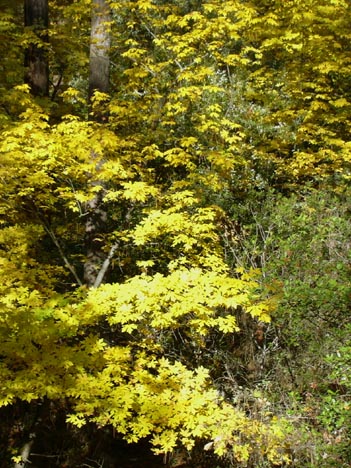
First going through a tunnel, the paved,
8 foot wide path leads along the freeway. Going over a small bridge,
I was assailed by sights of good color. Amidst the pines and firs,
big leaf maple and black oak made a spectacular, fall sight of
nature. I'd say it was at peak. I snapped away, and many users
were enjoying this fine, sunny day. Many walk their dogs, with
poop bags and disposal cans available at points along the trail.
The locals must keep this trail pretty clean, and free of litter.
Some roads are crossed, then a series of
small plaques are situated along the trail, honoring various persons.
To another major side road, I went left to walk along this paved
road, then to come to the big, official parking lot with the sign,
"El Dorado Trail." The trail continues east, climbing
gradually. Before the pavement ends, a concrete pedestrian bridge
crosses over U.S. 50, and the trail continues further along as
dirt. I will have to check this out sometime later.
I turned around at 3:01 p.m. The sun was
getting lower, and I knew to go check out the sunset. High clouds
promised a good one.
Back to my car by 4 p.m., I motored off.
Westbound on U.S. 50, I took the El Dorado Hills Boulevard exit
to head north. I found that Olsen Lane goes up to Gillette Drive,
then to Ridgeview. Kalithea Park offers a place to park, and walk
out and enjoy the view to the Sacramento Valley. I snapped a few
photos of the sunset. The electric lights of the new Folsom city
were winking on.
Motoring about this beautiful, and no doubt
expensive, neighborhood, I found other side streets to take me
to other views. This area is still in the process of being developed.
Once, I mourned the loss of the oak woodlands and the end to the
undeveloped nature of this whole area. Happy for the people who
now live here, I guess if I ever won Lotto big-time, I also might
consider some property here, too.
I did some 6 miles with 400' gain. I shot
66 digital images, and spent nothing except for fuel. A light
jacket was comfortable, with unzipping, while walking up the easy
grade, in the sun.
With more fog free weather on Wednesday
afternoon, I motored the short distance on Interstate 5 to Twin
Cities Road exit. Headed east, then south, I came to the gravel
parking for the Willow Slough Preserve, or also, the Cosumnes
River Preserve. The managing agencies have now built a concrete
sidewalk, in place of the dirt trail, for the first quarter mile
or so. Speaking with another user, he said they had just completed
this construction a few weeks ago. I was too rushed, later, to
speak with the people in the Preserve office, so I am unable to
confirm this. The planted oaks, near the start, are now up to
20 feet tall. They are of a rare species, growing only in California.
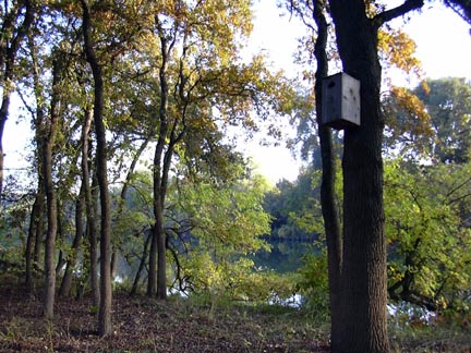 The
concrete sidewalk ends at the big bridge over to the main visitor
center. I headed further along the dirt trail, and saw that the
trail has been extended far along the Cosumnes River, past the
railroad bridge. Having the time, I followed the new trail through
more oak woodlands. There are not the vibrant, fall colors to
view, with mainly only the willows, and perhaps sumac, that are
turned. The still waters of the river reflected the colors of
the cottonwoods and willows.
The
concrete sidewalk ends at the big bridge over to the main visitor
center. I headed further along the dirt trail, and saw that the
trail has been extended far along the Cosumnes River, past the
railroad bridge. Having the time, I followed the new trail through
more oak woodlands. There are not the vibrant, fall colors to
view, with mainly only the willows, and perhaps sumac, that are
turned. The still waters of the river reflected the colors of
the cottonwoods and willows.
I had spotted a large bird in a sort of
"mangrove" swamp, and later snapped pictures of a cottontail
rabbit. Additions have been made to this preserve, and now this
trail is put in. Kayaking is supported, and it seems some minimal
impact camping, whenever they would allow that, might be fun to
do.
The trail goes out, then turns to loop
back on itself. I saw a few other hikers enjoying nature, and
then I headed to the visitor center. Donating a couple coins,
I sought to get information, but the attendants were busy. Back
to the trail, I came back to my car in time to wait for the sunset.
There is another concrete trail over to the extensive, wetland
side of the preserve. Several cranes and geese were about. A warning
sign cautions about disturbing the birds after dusk. I needed
a 10X zoom, but I walked back away from them rather than try to
get close with only my 3X zoom.
The sunset wasn't a really good one, so
I motored off at 4:50 p.m.
I'd say the total loop distance is now
some 3 miles. I shot some 100 digital images. I was fine with
a heavy pullover.
As the environment gains more attention
locally, money comes in to support habitat. Once a member of The
Nature Conservancy, whose extensive holding of preserves, world-wide,
is the result of perhaps the biggest fund raising effort to save
the planet, I am too strapped for cash right now to afford the
dues. But, it is a blessing to have local, natural, areas to be
set aside to allow the enjoyment of wildlife and some planetary
ecology.
BACK TO PETE'S THOUSAND
PEAKS HOME PAGE