MT. KAWEAH (13,802'), MT.
LIPPINCOTT (12,260'), AND SAWTOOTH PEAK (12,343') June 30 to July 4, 1984
 Then needing
Mt. Kaweah, a SPS Emblem peak, I scheduled and climbed these peaks
for my now, presently completed, list accomplishment goal, the
SPS Senior Emblem. Mt. Kaweah is the presumed, highest peak in
the southwest part of the High Sierra. Only one taker joined me
for this five day backpack activity. We hoped to get at least 4
listed peaks, but we had to settle for three.
Then needing
Mt. Kaweah, a SPS Emblem peak, I scheduled and climbed these peaks
for my now, presently completed, list accomplishment goal, the
SPS Senior Emblem. Mt. Kaweah is the presumed, highest peak in
the southwest part of the High Sierra. Only one taker joined me
for this five day backpack activity. We hoped to get at least 4
listed peaks, but we had to settle for three.
A previous local chapter trip saw the ascent
of Mt. Kaweah (a.k.a. Big Kaweah) with a few attempting, unsuccessfully,
Black Kaweah. That one is a highly coveted summit. I was determined
to do as well or better.
We carpooled to Mineral
King, where, in the morning, we took the Monarch Lakes/Glacier
Pass trail. This climbs some 3,400 vertical feet to Glacier Pass,
which is a sand slog
for the last several hundred feet. I had scouted this trail earlier
in the year, so pretty much knew the way. We descended on a snowbank
to Spring Lake, our first
night's camp. Mosquitoes were thick, but it is a beautiful campsite.
The rock face of Sawtooth
Peak and a sight of the alternate route, Hands
and Knees Pass, presented themselves.
Our next day's itinerary was to get to
base camp for our most important peak. We headed cross-country
north from Spring Lake. We found a slight use trail, for a short
section, to get to the Black Rock Pass trail. This trail switchbacks
nicely up to the pass at 11,600+. The rewarded view
of the Kaweah Spur is breathtaking. We descended on the trail to our base camp at
one of the Little Five Lakes. We spoke with the backcountry ranger,
who lived in a tent nearby.
He spent his days, then, fighting a fire singlehandedly, smoldering
to the south.
Having nothing else to do that day, we
made an attempt on Mt. Eisen (12,160') from the east. Getting
to what the ranger called Long
Lake, we couldn't discern the class 3 route that should lead
to the top. We went a bit further, but saw that we might exhaust
ourselves bagging this relatively unimportant summit, in lieu
of our main goal, Big Kaweah. So, we returned early to camp.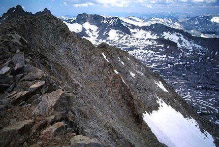
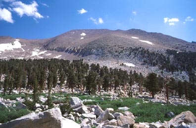
In the morning, on our biggest summit day,
the clouds were building up early. I could only hope that the
weather would hold. We took the good trail down into the Big Arroyo
and crossed the creek without problem. Connecting with the High
Sierra Trail, it led us up to a small tarn on the west slope of
Big Kaweah.
We simply headed up cross-country to the
top. The two thousand foot vertical climb is mostly class 1 or
2 sand and rubble. We came to the summit as clouds were moving
in. There was still a lot of snow on the peaks all about. Two other hikers had beaten
us, by minutes, to the first register
sign-in for the year.
We enjoyed the view,
and then started back down. Some peaks to the north do look higher.
I shot a photo (right). I wondered if we were on the right summit!
I had a nice glissade on a snowfield, passed by a spring,
then through some scenic forests,
and we came back to the HST, and then headed back to camp. I had
a look at Black Kaweah.
The weather had held, although some big thunderheads loomed over
to the west.
With our main goal accomplished, we rested
well at camp. But still full of energy, on our fourth day, we
chose to climb Mt. Lippincott (12,260'). We hiked a short ways,
along the same trail toward the Big Arroyo, then headed cross-country
again to gain the southeastern slopes of this peak. I ascended
a large snowfield, then, tiring of the mushy snow, took some talus
slopes to the summit. My companion chose to stay on the snow.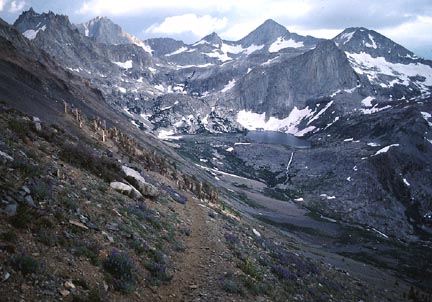 The
usual vistas were great.
The
usual vistas were great.
After this success, we packed up camp and
headed back over Black Rock Pass, and then back to Spring Lake.
There, we had a short, light rain and another beautiful sunset.
The next day's goal, Sawtooth Peak, loomed above us. Again, the
mosquitoes were bad here, but we used repellant.
On our last, fifth, day, we climbed back
up to Glacier Pass,
with a curious marmot inspecting
us closely. From near Glacier Pass, a sand trail leads further,
upward, to Sawtooth Pass. From here, we scrambled cross-country
over large talus blocks to the summit of Sawtooth Peak. This had
more great views, and
we lingered on this fine summit. I read later, in my SPS newsletter,
that a register I placed was almost full after a month.
We descended back to Glacier Pass and our
slightly hidden packs, then took the unmaintained Glacier Pass
Trail back to the cars. Our finish was at about 5 p.m., and we
had a long drive home. As we drove through the Central Valley,
we enjoyed a near continuous fireworks display from a series of
towns. We must have hit the time just right!
This trip probably entailed more gain and
miles than many regular hikers would ever do in one summer. To
climb Big Kaweah alone by this route would total some 12,000'
gain, round trip. I haven't calculated what our stats were, but
I'm sure they would be impressive.
BACK TO PETE'S
THOUSAND PEAKS HOME PAGE