UNDER CONSTRUCTION
Wishing for another activity, I phoned the local ranger districts, looking for information. Friendly and helpful, I told them of my hiking and website, and willingness to help hikers. The night before, I was drafting a webpage for assistance to be offered to Thru-Hikers for the Pacific Crest Trail. Enabled now for time and effort, I can provide lodging and local rides for backpackers doing the entire PCT for no charge, so they can rest and don’t have to hitchhike into town. The idea for me is to get some company and stories from people engaged in this magnificent effort. I am wary of pranks and bad guys, though, so I am being careful.
Getting up at a decent hour on this Thursday, I had in mind what to do. Having visited Frazier Falls in a heavier snow year, with the current drought, it was now already accessible. The ranger happily told me that it had been clear for three weeks. I knew that it is an easier hike, but figured that I’d find another good hike to do out there.
Being that I am at my computer all morning, and that it is not a long day to do it, I set out by about 11:30 a.m. Motoring on the highways north, I shortly came to CA 70, and headed west. My dash cam was running, and I figured to do speeded up video. While I have never gotten a comment or much from anyone about viewing any of these, I am happy to review them myself. It is all majestic country, and I like doing videos as they are so easily done, with my memory capacity. I snapped a few photos ahead, as there are peaks and road ahead. Passing through Chilcoot, Beckwourth, Portola, and then by Blairsden, I took CA 89 south. The gas station in Graeagle made for a quick stop, and I checked my map app.
Taking the Gold Lakes Road, it looked good for a short hike. I had to strip off my jacket, it was becoming hot in my car! Running video, I took the signed road from the north to Frazier Falls Trailhead. Not much traffic. In 4 miles, I came to the parking lot, where another truck pulled in behind me. The restroom was open, and I made a quick ready for the mile round trip.
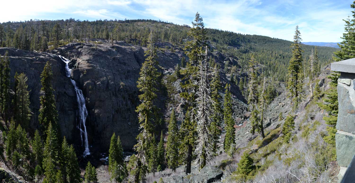
The trail is signed and paved. I enjoyed walking slowly, taking plenty of photos. This perhaps is one of the best things to do in Plumas County. Coming to the creek and bridge half way, I shot video, and continued on. Not much exercise, it is good for me at my age to be able to get out for anything. The other man with his baby was hiking out, and we chatted for a friendly bit.
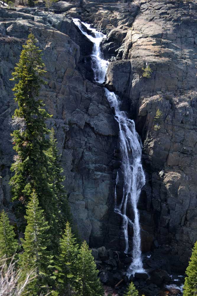
Coming to the falls overlook, I noted that it was running better than I had seen it in August, 2011, but not by much. The photo on the Forest Service page seemed wrong, but it showed a lot more water. There was a bit of snow present in the higher slopes to the south, but mostly it was bone dry. If I had ambition, I could probably begin a backpack from here to the Canadian border on the PCT with no snow to be encountered. Unless there was a cold storm, which now seems unlikely.
I started with camera work, doing video with my telephoto lens as well. With time, I did my own self in the video. Some group of people showed up as I left, one in a mobility cart. With the short paved trail, the disabled can enjoy the sights, and the woman said that the battery was good for 22 miles. I let them know of my website, as two other hikers appearing back towards the parking lot. I hope that I can assist in making a lot of happy hikers!
Running video on my good camera as I went back down the road, it had not gone so smoothly so the video is discontinuous. I had to stop to fix the problems, but no one came by.
Back to CA 89, I turned south. I’d make a driving loop. The sights of the forest were like summer. The rangers told me that the road to Webber Falls was closed, so I didn’t try to see that. I motored carefully, feeling funny in the head, and mindful of my weaker condition. The signs showed the distance to Truckee, but I stopped in Sierraville for a tamal and taco. A good rest break, and I tipped nicely for the service.
89 south went beautifully, and I remembered the many ski trips that we made along this highway. There wasn’t hardly a bit of snow, and it was like summer. I passed through the Truckee city limits, and then was headed eastbound on Interstate 80. If nothing else, I’d post a lot of speeded-up video to show my drive.
Too early then to head home, I opted for some reading, but the library hours were shorter this day of the week. There was a short hiking op on Peavine Peak, so I went for the West Keystone trailhead, to hike up the Poedunk trail. The sky was promising for red clouds, so I sought a view of the sunset. Mountain bikers came on down, and I gave them lots of room. I came to a small, flatter, rock to sit, and take my evening’s high point photos and vistas, and was disappointed in the not so great photo op. I had a view of the downtown area, which I admire. I haven’t gotten tired of that view, at magic hour, and I love Reno sunsets!
Hiking back down so slowly, I reached my car, which I hoped that the parking brake wouldn’t fail. The road out was rough for a hundred yards, then I was back to the paved Leadership Drive, and then was making a U-turn on North McCarran.
My app showed me doing a total of 3.09 miles with 16 flights of stairs. That seemed reliable. My hiking apps I stopped using as they show far more than I think that I did. I had some drink by my phone to pay, and captured 311 images and movie clips, with perhaps 4 hours of dash cam video. Spending 15 on the meal, there was 1.08 on the drink.
Using nearly half a tank, I did a lot of mountain driving, and will have to refuel for any other driving about town, or distant hiking. My plans for electric powered by solar haven’t panned out so well, with financing a major problem. I have a big bill to pay, and am still having to spend, as I can’t pass by the good deals, for now. It looks to save on food, and spend less or little on fine dining for the next few months, but with the short distances to gain, and views that I adore, hiking won’t be any great expense.
BACK TO PETE'S THOUSAND PEAKS HOME PAGE