TAHOE HIKES: LAKE OF THE SKY TRAIL AND MORE, MAGGIES PEAKS (8,699’ SOUTH SUMMIT), LAKE OF THE WOODS HIKE May 28-30, 2014
 Afflicted possibly with some bug, I was mostly down for the time on my return from Los Angeles. I rested and relaxed, with little medical help. It started to get to where I awoke every morning feeling terrible. I do get the “blues” when I’m not hiking, and no one was to ever come forward by the Internet for any teaming up to climb peaks or even travel. For peace of mind, I ended my Meetup group, as there looked to be zero interest, even with my generous offers. Knowing full well that no one likes to climb peaks as much as I do, the offers tended to be outlandish and would financially cripple me, if accepted. But, I was safe there.
With over a month since any hiking activity, I started to feel good enough to consider another trip. Being a drought year, the Sierra peak season was starting early. I looked at doing a few easy summits in Sequoia-Kings Canyon National Park, camping at Giant Grove or thereabouts, or some easy waterfall hikes by Lassen Park, with lodging in Red Bluff or Chico. Being that climate change is being pushed as a reality by the government now, I thought to limit any emissions and shorten my travels. No one evermore is going to carpool or share in an electric high end vehicle, but I do seek to travel green. So, to try to lose weight by exercise and improve my health through some hiking, I resorted to my old stand-by, the Northern Sierra.
Finding a great lodging deal in South Lake Tahoe, I’d do a small adventure and report on hiking conditions. In some years past, I’d climb Ralston Peak and post photos, which would show the snow, or lack thereof, with its fine views of the northern peaks. I still get so few visitors to my website, and I guess that people seek no good intel on hiking, maybe even preferring an unpleasant surprise by ignorance. I found a few things that I haven’t done, so Tuesday night, had a nice dinner of seared salmon and made some tentative plans.
Too excited then to sleep Tuesday night, I got out of bed at 3 a.m., Wednesday, and got to my computer. Making my motel reservations, I was feeling better to decide to do this, and left home by about 5 a.m.
 Motoring east on U.S. 50, I began to get drowsy, so exited at Missouri Flats Road for some diet soda. I made calls to my old peak buddy, but he didn’t answer. He is quite advanced in age, and says now that he can’t get to his phone. You only have so much time in your life to hike and climb peaks, and while he now says that he doesn’t care for scenery and achieving travel goals, I look back on my photos and videos, shared on the Web, and am uplifted by the memories of so many good times, summiting and safely traveling.
With lots of road work on the highway, I went to Pollock Pines to get some breakfast. Now feeling terrible, I had to make it to my motel, which doesn’t open for check-in till 3 p.m., and to do something in the meantime.
Stopping by the ranger station, they told me that there had been some rescue of lost hikers by helicopter. For complete lack of common sense and what many would term, “stupid hikers,” the rescue bill was $25,000. The ranger told me that the County handles the coordination and expense, and wouldn’t say if hikers are charged for rescues this year now, but to be forewarned.
I will still use my Personal Locator Beacon if I am immobilized and in peril, but I do have some money, and won’t hesitate to press the PLB signal button, rather than lay out there to die or to be searched for at high SAR costs. I carry my gear for survival, and can spend the night out. Bringing in some pack horses would be much less expensive than say a helicopter. They do gurney hikers out if it is feasible, but for peak climbers, you are in remote wilderness most of the time, on extremely rough terrain, and most get air-lifted out. I bless my lucky stars that I have had no misfortune, but still am careful, and am considering giving this up for safety reasons.
Motoring eastward was a struggle. All that I could think of was sleep. I made a quick stop at the Pyramid Creek trailhead, to have a look about. I expected to pull off the road and doze, but I made it to the Taylor Creek USFS Lake Tahoe visitor center. They have a nice public restroom, and the station was closed now (to June 14) midweek, but a ranger gave me some information.
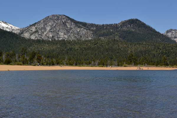
Going for a walk, I took the Lake of the Sky Trail which is short and easy, heading for the Tahoe lakeshore. Doing photos and video, I started to feel better. There is a lakeshore trail which heads for the Tallac Historic Site, and then I made a loop, taking the Tallac Promenade, chatting with other visitors. All of the new snow from the last storm was gone, and many peaks were hikable.
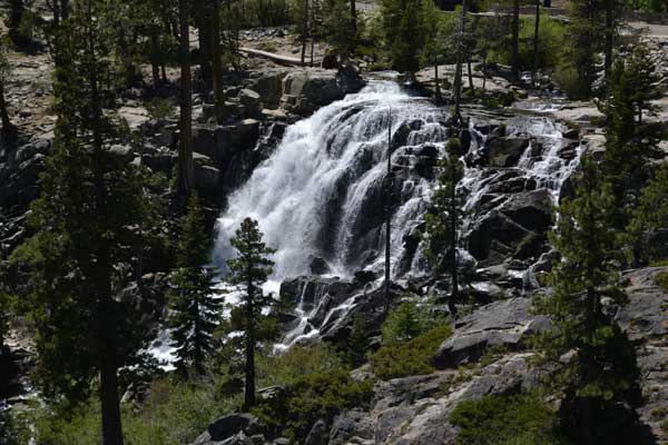
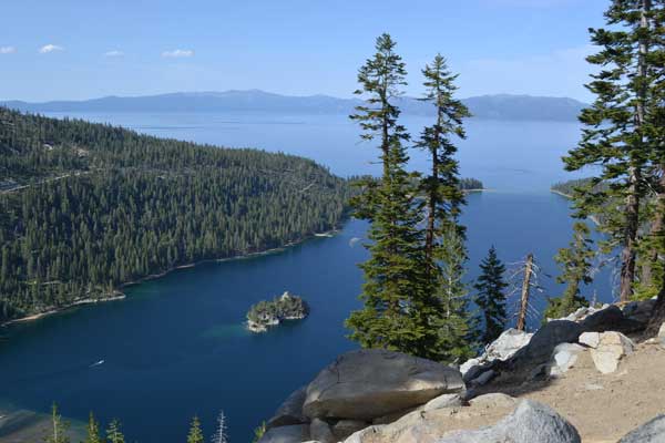
 Returning to the parking lot and my car, I still had lots of time before getting to being allowed check-in to my motel room. Motoring north on CA 89, I used my National Park pass to use the Eagle Falls fee parking lot. Going to my standard view for Lower Eagle Falls, I did my camera work, and more video to show how to scramble to my view. I took more time at the top of the falls, then took the trail over to Upper Eagle Falls. Slightly recovering then with some hiking, I then motored back south to Inspiration Point for the view of Emerald Bay.
Stopping by the Mt. Tallac Trailhead, I did a 360, to note there are still no outhouse facilities. My Peaks Guide is in bad need of updating, with new signs and other things. My only excuse is that with no partners or interest, I cannot get to repeat the climbs, as to get the recent information. If no one consults my online guide, and there is so much better information elsewhere by most peoples’ choices, maybe I should stop posting updates or anything, and simply remove the guide.
Going by the fast food restaurant when back to U.S. 50, I had a salad. It was time now for my rest. I got my room, and arranged for a two night stay. Going to bed, I didn’t have a good night’s sleep.
Thursday, I felt horrible. My thought was to sleep all day, and decline any hiking. It is old age, now, and I perhaps had better stop my travels, and simply die, or to retire from hiking and even driving. Up at about 6 a.m., I went three times for motel coffee. I got the news and Net information, and figured to make some effort. Some diet sodas from the nearby liquor store helped some. Going for breakfast, I had a burrito with plenty of diet soda. This helped a bit more.
Motoring over to the Bayview Trailhead for my peak hike, I’d see how I felt. Late in the morning, I liked the trailhead, with a facility, and in the far end of the campground. Packing my pack, I started up the trail by 10:45 a.m. I had all day to top the peak, one that I have never climbed. It would be normally a two hour climb, but I plodded up slowly, with fit hikers passing me by, quickly. I started to get views, and at a switchback on the trail, gained a fine vista of Emerald Bay. Stopping for camera work, this lifted my spirits. The other hikers were an encouragement. Fit, good looking people. There were loose dogs, but no pit bulls. I had my ice ax in my hand, mindful that the ranger had said that he had given out many tickets for unleashed animals.
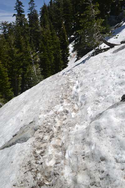
Soon, I was hiking further, past Granite Lake. There was a cloud of mosquitoes here, but I didn't get bit. These were the only ones that I saw on this trip. I never used repellant, but got reddened by the sun. At a nice rock slab, I took a rest. I used my pee bottle, and felt more comfortable. The trail climbs up, and then came to snow. I even chopped steps to facilitate travel, and to avoid adding to the trail erosion where hikers were avoiding the steep snow. No other hikers had snow climbing gear. Some people climbed above to cut the trail, but I stayed on it, chopping more steps.
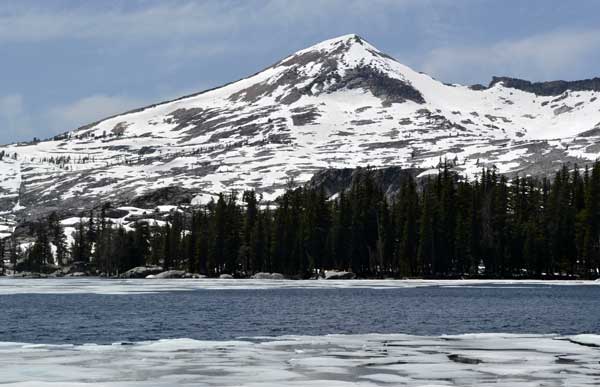
I then came to the ridge, and two use trails headed each way to either of the Maggies Peaks. The south summit is higher, so I sought that first. Following a semblance of a use trail, I navigated up the patchy snow, and kicked steps for any game to follow. It is a safe enough, shorter distance to the top, and as I got there, other hikers appeared.
Determining that a boulder with a small rock window at its top was the highest point, I scouted about it for the moves to touch the top. Two of the other hikers were atop some slightly lower rocks to the south, which had a better view without trees. Becoming worried that this perhaps would be a class 4 or higher boulder, I found a ledge and made some moves, finding holds, to reach up and touch the highest point. So, I can claim this peak!
 The other hikers left, so I wanted a 360 and to do a summit twirl. I scrambled over to the top of some class 2 rocks for an alternate summit, maybe 100 feet to the south, as the true highest point is not graced with the best view, or a safe or convenient place from which to snap photos and video atop. I’d add this peak to my Northern Sierra Peaks Guide, as it is found in online hiking websites, but none mention the class 3 boulder as the true highpoint. Taking photos, I then went back to the class 3, 10 foot high boulder to do a video of my touching the top.
As many summits, most climbers will decline to do this, touching the true top. So many local hikers refuse to climb over to the true highpoint of Castle Peak, and Round Top. Fine for safety, but the old hiking club would claim an ascent, sometimes falsifying that they had achieved the true top. Your own standards by me, but I like it that I so truly climbed to the top, in contact with the exact highest point! I don’t count Sauk Mountain, Laramie Peak, and a couple others for lack of meeting my own standards. I sleep good at night.
One mountaineer said of the false climbers, “They’ll just roast in Hell.” Most people take this lightly. With so many mountaineering clubs filled with liars and frauds, and Internet sites devoted to pure fabrication, it’s easy to see why perjury isn’t mostly considered a prosecutable offense. Honest people are so rare. Newsworthy items if one is found as such!
Descending down the slopes, I managed to do a few short standing glissades assisted with my ice ax. Back to the trail, I checked the use trail heading for the lower north summit. It entered a class 2 boulder field, with a drop to a saddle, so I will save this for later. It did look to be more of a challenge, but I had felt so horrible this day, and one true summit was enough to savor.
I climbed down the snow, and followed the trail down, looking for another use trail that might head off for the north summit, down from the saddle. Nothing to be seen. Taking my time, I stopped back at the nice rock slab and rested. Nice weather and conditions, and I had time. No rush, as with the old hiking club, and having to get back to town.
Stopping again at the view of Emerald Bay, a few chipmunks made for photos. I entertained myself with my selfies, knowing that the car was only a half hour away. Some slight burn area on the way down. Back to the trailhead at 5:40 p.m., I declined doing another hike to Cascade Falls. Setting video, I drove back to CA 89 and ran HD, driving south with a view of the Lake, and over the narrow, precipitous section atop the moraine with drops on either side. This all made me feel really good!
Going straight back to my motel, I’d not eat dinner, resolving to try to lose weight. My lifelong health problem has been being overweight. While I did slim down after really strenuous hiking and climbing, I always gained the weight back by dining too much afterwards. Getting online, I rested and relaxed, feeling great now. Many hikers and backpackers that I saw later were grossly fat. Desperation to spend on hiking gear and to try to slim down that way. It’s the eating!
 Sleeping later on Friday, I wasn’t feeling so great, as the evening before. I had planned to climb Ralston Peak for my 30X, so I set out to do that. I’d try it by Echo Lakes, my Route B. I was going to have a good breakfast, but on the fly, went for the fast food to get a smaller meal, with plenty of diet soda.
Motoring west now on U.S. 50, there were road work delays, and then taking the old Johnson Pass cutoff, came to the Echo Lakes Road. I found a parking spot by the chalet, and they told me that the water taxi was $12 each way. But, it is $36 minimum for a trip. Two other hikers were taking it, so I decided to give it a try.
Running video as we motored across the lake, I felt some guilt, as this uses motorized travel to climb a peak, versus hiking the 2.5 miles around the lake each way. Well, the old hiking club had changed with its elimination of peak bagging, rock climbing, and skiing. Most or all of the old peak hikers and regular hikers don’t hike, for decades.
We came to the upper lake dock, and the boat ride was worth the money. Starting up the trail at 11:15 a.m., it shortly comes to the Pacific Crest Trail, and I was on my way. I knew that this trail is rocky and poor, and I sought to do it safely. There are slippery spots, and water running on much of it, but I was hiking now, and climbing up the trail. Taking photos of the post signs at the trail junctions, they indicate “Triangle Lake,” not Lily Lake, as once before. Confusion for anyone following my peaks guide. I had it in mind to do Echo Peak if I hadn’t felt very well, but I continued toward Ralston Peak.
Coming to the high saddle with the trail junctions, about Haypress Meadow, there was snow. Boot tracks led on, and then I was passing some backpackers, and slathered on sunscreen as I stopped at the signpost. Another few hikers stated to wish to go to Lake of the Woods, but the trail was covered in snow. I know the way, and offered to take hikers to the view atop a hill along the way, but all refused.
Snow hiking on, I found some footprints, and followed them on up, as they headed in about the right direction. My ice ax was so handy. The snow cover was suncupped, and thus harder to hike over. I knew by recent memory that the hill and view wasn’t far, and shortly came to bare ground on the far side of the ridge. I saw that I was too far to the north, so hiked left to find the trail.
Out of the way slightly for a Ralston summit, I then chose to hike to Lake of the Woods, which was seen below, not far away. If I had chosen to summit Ralston Peak, I wouldn’t make the last time for the boat operation, 5 p.m. Not feeling hot, I’d have to hike back, around the lake. Too bad, though, that those other hikers weren’t so game for snow hiking.
Descending down the trail, I’d resign myself to an easier, non-peak day. There was more snow, though short undercut sections over the trail, and shortly, I was to the lake. Backpackers had just gotten there and set up camp. I found a nice rocky point jutting out on the lake, and dropped my pack, to start camera work. I did a 360, and video. The ice floes were breaking up, making for videos, and a duck swam and waddled across floes. Enjoying the moment, this might be a life changing instant in my time, switching from summits to easier hiking, and to relax and enjoy in the mindset of other hikers.
The old climbing club rejected mountaineering. Legal liability was stated to be the reason, but most people refuse “work,” by their execs. Now even hiking is a target. Most people world wide are obese and overweight, me included. But I don’t have to like it. I was feeling excellent and fit, returning from a good peak or peaks. The best feeling in the world. The club would rather their cars and eating, sickness, and pollution. I know better.
Climbing back up the few hundred gain to the ridge, and then back to the snow hiking, I’d seek to take the boat back. I followed the trail, and then on snow, blazed a more direct way back to the main PCT junction. Maybe 15 minutes of snow hiking. I hiked back south on the PCT, with heavyset backpackers coming up, in shorts and T’s. Well, an effort, though futile, for me. Hiking slowly down, I came upon more backpackers, and figured to see what about the boat ride.
 As I approached the dock, I heard the boat taking off, then witnessed quite portly backpackers going up the trail. Arriving to the dock at about 4 p.m., I’d wait for the boat to make a trip, or other hikers to come by to fulfill the $36 minimum. There is a pay phone, so I first tried for a signal by my handheld, but by the wooden booth there, they picked up at the other end with no charge. I asked about the chances for a boat to come by, and they said that they was nobody in the parking lot there.
Waiting to about 4:50 p.m., I figured to hike back on the trail around the lake. Hiking back to the PCT, I heard the boat. Running back, the boat had come by, but with no load of hikers. The guy stated the $36 minimum, and we waited for any last minute hikers to arrive. I figured then to spend the money, as it’s such a good deal even then, compared to say some broken leg or feeling horrible, as the other morning.
I ran video as we motored over the Echo Lakes, with spray as we hit choppy waters. The ride takes 10 minutes, and I paid the fare once back to the station on the other side. I mentioned that I had paid $35 for the nighttime ferris wheel ride in Vegas, so compared to that, this wasn’t so bad.
Emptying my pee bottle in the facility, I was rested and relaxed for my drive home. Motoring back out to U.S. 50, I stopped for a drink at Strawberry, having noted Horsetail Falls running well. Hoping not to eat much, I stopped at the casino for a break, and dined on diet soda and a plate of vegetables. Lots of older people at these places, and with no venue for healthy hiking activities supported by anyone, this may be the way it goes, further, for me. I am not a big gambler, but playing cards may be an outlet for my energy and money.
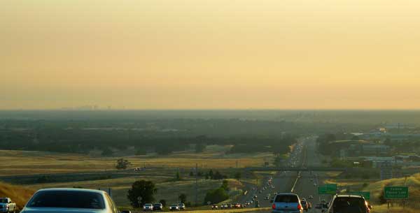
A layer of smog lay over the Central Valley as I descended into town, and I knew that I’d experience Fix 50. Coming into slowdowns as I came to the sections under repair, I exited and took side streets to do some shopping before returning home.
Hiking then about 12 miles with 3,000 feet of gain, I had driven 250 miles. Used maybe 6-7 gallons bought at 3.899. Capturing 782 images and movie clips, I spent about 150 cash, with 85 charged for lodging, so not too bad. I feel slightly slimmer, and with some resolve to lose weight. This’ll be a project, to lose more weight, and abstain from peak exercise with excessive eating. Salads, no binge eating or snacks. A reasonable, healthier lifestyle. Peak hiking has me fear for running out of energy, so then I eat. No more, I hope.
BACK TO PETE'S
THOUSAND PEAKS HOME PAGE