March 25, 2014
 I had to do a lot of driving this day, so got up early. Making some 8 or 9 crossings of the Continental Divide this day, I had a zig-zag and criss-crossing route. I had never been to many of these parts, so had some uncertainty. Road trip adventure, with some precautions. Taking Interstate 10 east to NM 338 south, there was a wind storm. It subsided as I passed a dust cloud by, so I did video headed for Animas, NM. Gratefully, there is a business, so used the restroom and bought a soda.
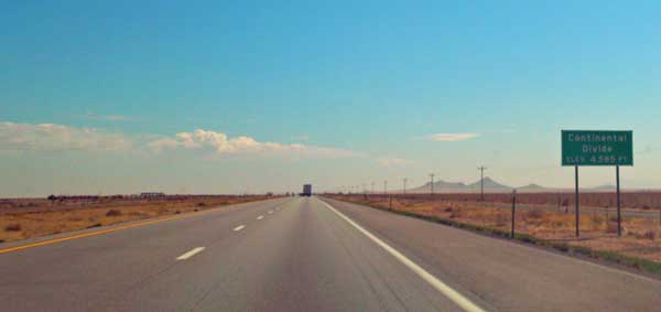
Now heading east on NM 9, I had my first crossing to do. My AAA map isn’t too precise, so I guessed at where the pass crossing was. Setting video to run, I started east, with my estimate of the location of the crossing. At the Divide, there was a sign marking the spot. Good!
I continued east to come to NM 116. Taking it north, there is a crossing about 10 miles ahead, so let my video run, again. This is mostly flatter, dry country, so there is not much to see. I picked a partly cloudy day for the sky to be more interesting. There was indeed a sign, again, but I drove on a few more miles to be sure that I had crossed the Divide, then turned back south to cross it again.
Back to NM 9, I continued east to Hachita, NM. This was an empty town, with a historic marker. I took photos, and then headed north on NM 146. The map had shown the line marking the divide to come close back to NM 9, east of 116, and I had my video running, but saw no signs. By the Net, it crosses maybe twice about here, but I have to research this later.
My video didn’t record right as the lens had been zoomed out unknowingly, so my capture was of the sky, nothing else. So it goes. So, the crossing on NM 146 was not captured. No sign, anyway. I did some other video as I passed by desert plants, and then came back to Interstate 10.
I had to do a jog east to cross another Divide pass, and it came up sooner than I had expected, by my map. I continued to an exit and turned back west, to cross it again. With few or no cars on the road, I felt safe enough to let some video run. I have a high concern for any accidents, as this may be considered distracted driving, as I do have to have some slight attention paid to my camera running, but as with the hiking club, they have gotten into accidents from, say, a insect getting into the car. There are people incapable of concentrating on the driving and with low safety concerns, even with passengers. Not me!
 So, zooming back west on Interstate 10, I came to Lordsburg, NM. Not much in this town. Taking NM 90 northeast, I had my fourth or fifth Divide crossing. I set my video, successfully, and saw a sign for the Divide. This is nicer country, going north towards some higher peaks, up to 10,000 feet or higher.
Knowing from research that there is a cutoff road, I took it towards the next crossing, on U.S. 180. This was signed, shortly after the junction from the cutoff road. Able to turn about, I let the video run again as I approached Silver City, NM. This is a nicer town, like a resort. Good for another visit, some day.
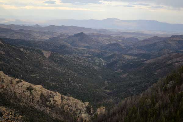
Another crossing was northward on NM 15. My video ran nicely, and there again was a sign. It turns into a scenic drive, and winds through a nice New Mexico forest. My side trip destination was Gila Cliff Dwellings National Monument. It closes at 4 p.m., so I didn’t want to miss the hike to the settlements of ancient peoples. Motoring along at good speed, I made a stop at an overlook, and then was arriving to the park.
Stopping at the visitor center, I got information, and good on time, drove over the two miles to the cliff dwellings trailhead. Volunteers were on duty, and I started with my half mile hike, each way. They built several footbridges, and the trail winds through a small canyon over a bubbling creek. It climbs 200 feet to the dwellings, and I ran video, snapping pictures. A ranger was stationed here, but allowed going into the caves, where I ran more video as I hiked on through. There were a few other visitors, but being so far off the beaten path, this monument must not get so many visitors. Spending then about an hour, I hiked back, having filled out a ticket stub with my pass number written on it, then deposited into an iron ranger. Restrooms to use.
So, mission accomplished, I motored out of the monument, back south. There was another view to capture, and then I came to NM 35. My last crossing for this day, I set my video to run, but saw no sign. Scenic drive, anyway. Coming then to NM 152, I headed east. This is good, high country, with Emory Pass. I set video again as it was too pretty to ignore. There is an overlook by the pass, and then it descends into lower terrain, and mostly there was no or little traffic.
Finally coming to Interstate 25, I headed north to my motel at Truth or Consequences, NM. There hadn’t been much for dining ops, so tired, I walked over to the fast food eatery and carried back a salad for consumption in my room. It is good to have visited for any familiarity, should I return with partners for peak bagging or even just hiking and travel.
2014 New Mexico Road Trip Home, 23, 24, 25, 26, 27, 28, 29, 30, 31, 1, 2, Movies
BACK TO PETE'S
THOUSAND PEAKS HOME PAGE