MT. HARKNESS (8,048’), HEART LAKE, AND MORE September 5-6, 2012
 Seeking to do a three day trip, extendable to longer, I couldn’t get to sleep, Wednesday night. I got up from bed, and to my computer to get the news, then left home at about 4 a.m. I had made my room reservations the night before, and knew roughly what my plan was.
Taking U.S. 99 north to CA 70, I got gas in Marysville, CA, at 3.979, and then had a stop for breakfast in Chico, CA. Headed north on CA 32, I made a stop at Deer Creek Falls since it is a very short hike down to the views, and did a record of the flow. I reached CA 89, and drove east to Chester, CA, where I began to nod off a bit. I had some coffee, then took the rough dirt road to Juniper Lake. I made it to the Mt. Harkness trailhead, and started my hike up this notable peak.
On my way up, I remembered that I had forgotten to put my park pass on my dash or in the holder that I had been given at some park, earlier. There is no entrance station for this road, only a self-pay station. I worried greatly and figured to rush the peak, so I could get back without some sort of ticket. I had my pass, so could explain to a ranger that I simply forgot, but some don’t allow for excuses. I did my photos and video, anyway, and saw a deer bound away. I came close to the top, and hoped the lookout might explain it by radio, so I wouldn’t have to pay anything else.
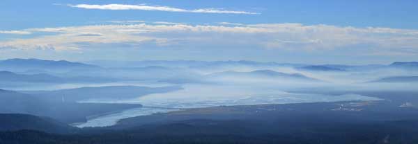
Summiting in over an hour, I spoke with the lookout, who said not to worry. I did my view photos, and he said it was a good day for that. There are fires going about the area, but no smoke or haze obscured the gorgeous scene. The lookout wanted to talk, but I had to leave. I went over to a point with a view away from the tower, and did a 360. Rushing back to my car, I found no ticket, but I motored off, with a ranger in the area.
 Back to Chester, I had to sooth my shattered nerves with a icy drink, and regretted that I am getting forgetful in my advancing age. I took CA 89 north into Lassen Park, doing video as I motored along. No traffic. I think that I am getting the knack of video while keeping to the driving, safely. Making a fast stop at Bluff Falls, then at the Kohm Yah-mah-nee visitor center, I stopped at the Sulphur Works for some quick photos and video, then motored up to Bumpass Hell parking lot. Nice to have gotten up early today, I was now refreshed and good for another hike.
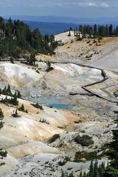
Taking the trail to Bumpass Hell, I enjoyed the views along the way, and then came to the many walkways that allow for close views of the fumaroles and vents. I shot video and many panoramas. A fellow asked about a ride back to his car at an alternate trailhead, so he could do a one way hike. I agreed to take him and his companion, so let them go on ahead, as I stopped for more photos.
Back to the parking lot, I loaded the two into my back seats, and drove past Lassen Peak trailhead to know that the summit trail was closed for work, in intervals this year. A 7X would be nice, but for lack of time and energy, too. I dropped them off at the trailhead for Cold Boiling Lake, and found out about more hikes to do. With no cars on the roadway, I shot more video, and passed through the recent Reading Fire burn area.
Getting to CA 44, it was only some 46 miles to Redding, CA. I zoomed west, with views of the sights ahead. Into town, I got mixed up looking for my lodging, then checked in. I washed up, relaxed, then headed for a nice eatery with a view of the Sacramento River. It was past sunset as I got a table outside, but enjoyed my meal, with good service. I made sure to tip nicely since they didn’t try to stop or interfere with my photography. Not like my old hiking club!
I dozed off after watching TV, then awoke early for more things to do this Thursday. I planned for three peaks, minimum, but my second peak, Mt. Bradley Lookout (5,556'), began to sound like it was more than I figured. Good to have reports on the Net! I had an alternate peak, Mt. Ashland (7,533'), in mind, but first motored north on Interstate 5. I began to see smoke, and fretted a bit.
The Mt. Shasta Ranger Station did a banner job in giving me information. I confirmed that it is a rough trail, with brush, for Mt. Bradley, and they told me about an easier peak with similar views for Castle Crags and Dunsmuir. Looking at their computer, they showed me smoke at Ashland, OR, by webcams, and said nothing about the smoke forecast. Just what the wind does, and how bad the fires rage.
I took U.S. 97 northeast from Weed, CA, to see smoke to the north. I figured then not to do Mt. Ashland, and even to cancel my plans. Motoring 20 miles to the Mt. Shasta Vista Point, I did photos and video, chatting with a few people. I headed back to Weed, where I used my app to cancel my reservation for the night by good, free Wi-Fi. So, I’d be home this night, if I didn’t figure to go back to Lassen Park or any other such hike.
Driving to Castle Lake high above Mt. Shasta City, CA, on its west side, I would check out the USFS information. They gave me a map photocopy, and some verbal information. Starting at nice Castle Lake, I took the trail towards Mt. Bradley Lookout. It is steep with tree roots, and then it climbs out into the open, with views. There aren’t any trail signs to point out the junction to Heart Lake, with various use trails in many directions, but I navigated correctly to Heart Lake, with a view of Castle Lake and Mt. Shasta.
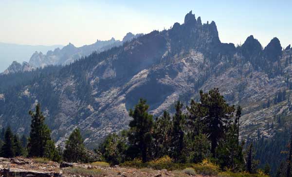 Backtracking a short bit, I found the “user-created trail” to the high ridge rise, about 6,300 feet elevation, on the Mt. Bradley Ridge. It is discernable enough, and climbs up to a ridge, and traverses through brush southward. It is narrow and sidehills along, but I then shortly came to the spectacular view of Castle Crags. Magnificent! There was smoke in the air, but the view is worth the values of wilderness.
I checked out the slight ridge rise nearby, with no good use trail to the top. There is brush, and a large class 3 or so boulder that comprises the highest point. I circled about the brush to gain a view to the north, but won’t consider this a peak. I declined the brush hike to top the boulder, and started back for the use trail. Footprints indicated that other hikers come here.
Hiking carefully back to the main trail, I ran into more hikers, and then came back to the parking lot, after more photos of Castle Lake. I did more video as I drove down the road, and came back to Mt. Shasta City, where I had a salad.
Wondering about what more to do before heading home, I thought of another visit to McCloud Falls. Instead, I exited the freeway at Dunsmuir, and saw signed Hedge Creek Falls. A short hike down the good trail brought me to the falls, still running. In all these years, I had never visited these falls. Good to have done it, with photos and video for the world to see on my website, I zoomed south on Interstate 5, with road work.
I snapped more photos as I motored along, then with a sight of the smoke cloud from a fire by Rumsey, CA. You could almost see the flames from the Interstate. I motored into town, getting gas in Williams to get me home.
Hiking about 10 miles with 2,400 feet of gain, I drove 658 miles, using about 16 gallons of gas, paying $63.50 enroute. I spent about $145 cash, with $50 charged up for lodging, and my connection. I captured 832 images and movie clips. So, only one peak, not three or four, as I hoped for.
I’ll have to tend to my traveling needs, and get back to enjoying the remainder of this summer. I wore mainly a T shirt and shorts, with Hoody and jeans at cooler times. Forgot my gloves, and never wore a warm cap. Some bugs, but didn’t notice many mosquitoes or ticks. Didn’t use sunscreen or repellant. I drank only two liters of water from the trails, and packed light, for me. So, I never made it back to Oregon. I do like my apps to search for highly rated dining, as the reviews seem good. I used my a/c a lot, and suffered a small scratch from the brush. Complaining about no partner to share and for safety, it seems that no one still wants to hike, climb, or ski, with me, or even to travel together!
BACK TO PETE'S
THOUSAND PEAKS HOME PAGE