HIDDEN FALLS REGIONAL PARK November 26, 2011
 Looking to escape the local fog, I had read about this fairly new hiking and sightseeing op not far away in the foothills. Leaving home at about 1:40 p.m., after a walk in the morning to get the news and some more turkey with trimmings, I took Interstate 80 eastbound. Fast getting to Auburn, CA, with a minimum of four lanes each way going through Roseville, now, I headed north on CA 49. I had the names of the roads to take, in my memory, so followed the signs to the park. The turn to make, Mears Road, is not signed for the Park from the Auburn side, but I took it, and followed the now well signed way to the parking lot.
Starting my hike by about 2:40 p.m., I took the dirt road northward, and took photos. Plenty of hikers about. I was annoyed by the sound of distant gunfire, as the park is surrounded by private land, and shooters must abound. Some mountain bikers enjoyed this road. The dirt road circles around and comes to a bridge crossing the creek, then the trail to the falls goes left. It meanders along, then comes to a set of rock stairs down to the final section of trail.
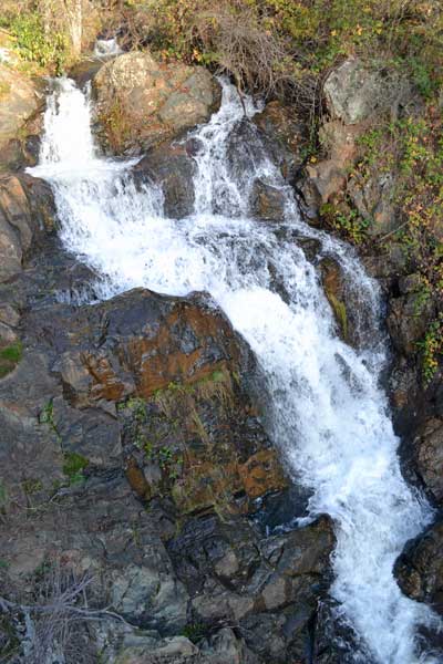
Humanity then began to appear. I had to wait for hikers, and then I came to a sight of the overlook platform. People with babies and infirm seniors could not be easily passed due to the narrow trail. I waited, then finally came to the sight of the falls. Photographers sought to get the view. I shot handheld, as tripods get in peoples’ way. Not taking long, I finished with my movies, and left the area.
I was mostly alone on my way back, so was able to now shoot the rough final section of trail. It was nearly too much for other people. I hiked on back, enjoying the fall colors and the absence, now, of the crowds. It would be dark soon, but some hikers were headed down to the falls, still.
Back to my car at 4:10 p.m., I motored off, and navigated my way back to the Mt. Vernon Road. Going west, I sought to make a driving loop and do some exploring. I took various roads through the scenic countryside, with plenty of reds, and the sun setting in haze. I had an image of the area by my maps, so soon came to the outskirts of Lincoln, CA, and then Highway 65. Massive tracts of new development made for a sight, and then I intersected the Interstate. The sky ahead was filled with dusk light, and I finished the 88 mile round trip drive, with perhaps 2 miles hiked, and 400 feet of gain.
I captured 169 images and movie clips (57.4 MB, 1:37, 720p HD). Spending 10 dollars for gas at 3.529, I never had any food or drink. This was a short, pleasant, half day for me, and the photography is good. I expected that the falls would be a trickle, but they seemed to be running well. There are tick warnings, but I didn't see any. Hardly any bugs at all. I saw no animals of note except maybe birds. The dirt road didn’t seem to get too muddy, but the trails might get slippery. I expect that I’ll be back, for gushing waters when it has rained heavily, and to again enjoy this natural treasure, so recently introduced to the public.
BACK TO PETE'S
THOUSAND PEAKS HOME PAGE