 U.S.
50 RECON January 20, 2007
U.S.
50 RECON January 20, 2007U.S.
50 RECON January 20, 2007
Initially planning to climb Ralston Peak, I had a few alternate plans for there being too much snow on the regular trail. I gained a partner, to have him cancel at the last minute.
Ready to go, having gotten a good night's sleep, I took off and motored east up U.S. 50. The sun was rising, and things looked pretty good. It hadn't snowed for awhile, and I had looked through some old slides, taken January 27, 1991, of another mid-winter snow hike to the top of this relatively easy peak. Being more energetic, and with my old timer buddy, we summited as usual, each year, back then, during the off-season.
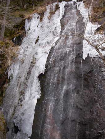
As I passed up along the South Fork of the American River, I managed to take a photo stop at Bridal Veil Falls. I usually pass this by with little interest, but with the cold spell, there was ice formed with the falls. This doesn't happen that often. I stopped there again on my way home with slightly better photo results.
I stopped again for shooting some ice and snow formed in the river, and then felt well about doing a solo peak. But, as I passed Strawberry, I saw that there was still a lot of snow on the peak's south slopes.
Coming to Sayles Flat, the normal trailhead, a foot high snow berm prevented me from getting into the parking area. The trail would be covered, anyway, but this was upsetting. My guesswork wasn't very good. The other fellow was smarter, canceling to do another activity. There had been a lot of icicles along the highway, and I might have expected hard snow or icy conditions going up the peak.
One of my plan b's was to head for Tahoe and loop over north to Reno, making a scenic snow drive. This didn't seem too smart, this day, with high clouds and hazy sun. I've seen it all, many hundreds of times, and the sights of winter beauty are much better from skis in the backcountry.
 I
turned about, backtracking a couple times. I braked along a wide
section of the highway, with "no stopping" signs everywhere,
to snap some fast telephotos of Horsetail Falls. I surmised it
would be frozen, or at least in some unusual condition, but the
Pyramid Creek Trailhead parking lot was gated closed. I couldn't
even stop to think what to do! The falls were covered with snow,
and I suspect some ice was underneath. But there was no way to
get to it, right now.
I
turned about, backtracking a couple times. I braked along a wide
section of the highway, with "no stopping" signs everywhere,
to snap some fast telephotos of Horsetail Falls. I surmised it
would be frozen, or at least in some unusual condition, but the
Pyramid Creek Trailhead parking lot was gated closed. I couldn't
even stop to think what to do! The falls were covered with snow,
and I suspect some ice was underneath. But there was no way to
get to it, right now.
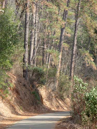
Headed back west on U.S. 50, I figured to stop near Placerville and recoup with a hike along the El Dorado Trail.
The light was nice for the forest. I saw many other walkers, and only one cyclist. People haven't been properly disposing of their dog poop, despite the waste stations and blue bags provided for free.
I completed the six miles, and then was on my way. Seeing it was too hazy for a photo stop at Kalithea Park, or with no parking information to check out the fairly new bike trail in El Dorado Hills, I motored back into town.
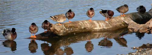
Taking Sunrise Boulevard north, I drove over to the Old Fair Oaks Bridge area to check on the overhanging trees. They hadn't yet fallen over. The light made some interesting photography, and roosters and ducks made for good movie clips. I am amazed at the quality and apparent steadiness of the movie image. I wondered if the VR feature helps keep the frame almost rock steady!
The bluff cliffs here have proved hazardous for youths, with rescues becoming necessary. Maybe lights at night would afford some vision of the cliffs with no guardrails.
I shortly left, and came home at a very early hour, 3 p.m., for me.
With only six miles and maybe 400 feet of gain hiked, I shot 277 images and movie clips. Needing no food or soda drink, with plenty of my own water, I had partaken of little exertion to counter the effects of my normal gluttony.
 Still
hoping for a good partner, the Sierra backcountry has too much
snow for hiking. Maybe a hike or peak in the Coast Range would
be good, then. I'd have probably hiked the Cold Canyon Loop, 16x,
had this person not come forward to do Ralston Peak.
Still
hoping for a good partner, the Sierra backcountry has too much
snow for hiking. Maybe a hike or peak in the Coast Range would
be good, then. I'd have probably hiked the Cold Canyon Loop, 16x,
had this person not come forward to do Ralston Peak.
BACK TO PETE'S THOUSAND PEAKS HOME PAGE