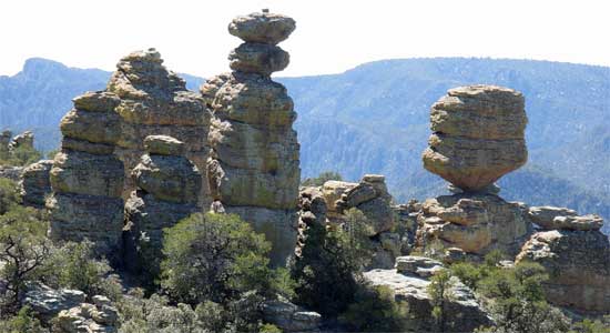
 This
was pure Interstate culture. My plans were to hike Chiricahua
National Monument again, as I did in 1998. The various rocks and
countless pinnacles made for such eye candy!
This
was pure Interstate culture. My plans were to hike Chiricahua
National Monument again, as I did in 1998. The various rocks and
countless pinnacles made for such eye candy!Winter Arizona Peaks Loop 2 (continued)
I then headed eastward again on Interstate 10. I had thoughts of going all the way to West Texas, to climb Guadalupe Peak, and see White Sands National Park in New Mexico on the way back. But, today, it was just to Willcox, AZ, to get more inexpensive lodging.
This
was pure Interstate culture. My plans were to hike Chiricahua
National Monument again, as I did in 1998. The various rocks and
countless pinnacles made for such eye candy!
Waking up early Thursday, I motored into the Monument. I inquired about hiking Silver Peak (7,975') which has a scenic trail to the top. It is in the nearby Coronado National Forest. With the trail along north-facing slopes, and with recent snow, it was a forgone conclusion that without ice ax and perhaps crampons, I should not try it.
Parking at Massai Point, I was soon taking the trail to the Heart of Rocks loop. I shot hundreds of photos. A few other hikers were about, and I was so pleased that the main balanced rock was as it was. I took my own picture with it, and continued along this trail loop. On my return, I did the half hour side trail to Inspiration Point, and then hiked back to Massai Point. I had enough time to bag Sugarloaf Mountain, 2x, then made it back to the NPS visitor center before its closing. I wished to check back in, and give a trail report. Some snow and ice lay across the Sugarloaf Mountain trail, presenting a slight hazard. I said about 50 yards, total, of icy snow needed to be carefully hiked over or around.
Back to Willcox, I had another nice meal, then retired to the motel.
So, Friday, I woke up early again, and headed east a short ways on I-10, then north on U.S. 191 to the Swift Trail Parkway highway, AZ 366. I shuttered a nice sunrise and a view of the mountains, enroute. This scenic but winding highway normally leads to Mt. Graham (10,713'), the highest peak of this range, the Pinaleno Mountains. The road was plowed, but there was a gate. I talked with a USFS worker who directed me to the 2.2 mile each way, side road, to the top of Heliograph Peak. This road was gated, and now with a few feet of snow on it. I resolved to do this easy ascent, as it would have a great view, and the snow was compacted enough to hike over.
With as much as 3" of old powder snow over a firm base, I snow-hiked up this road, and in an hour, reached the top. I went over to the edges of the summit area, with its communication towers and a lookout. It is a 7,000' vertical drop to Safford, AZ, and the views in other directions were so clear! I made sure I got photos, with three cameras. It was then time to head back, and the old snowcat tracks again made for a firm walking surface.
I motored back down the highway, and a strange looking squirrel darted over the road. Some rare species live up here, and so then, there was a controversy about a new observatory being built here.
 Into
Safford, I got food and drink, planning to enjoy the highways
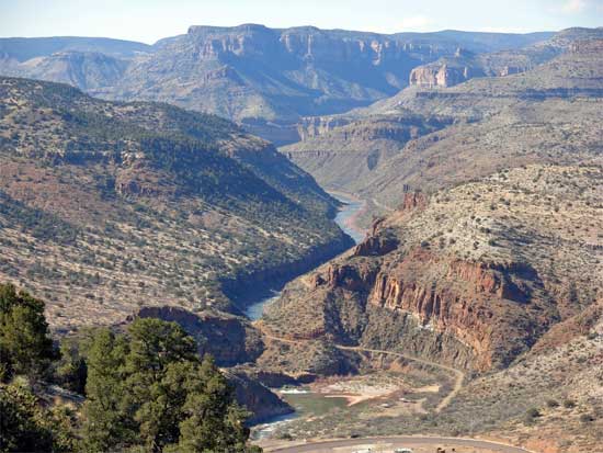
north. I took U.S. 70 to Globe, and then U.S. 60/AZ 77 to the
Salt River Canyon. This is another scenic highway that I wished
to see for some time, now.
Into
Safford, I got food and drink, planning to enjoy the highways
north. I took U.S. 70 to Globe, and then U.S. 60/AZ 77 to the
Salt River Canyon. This is another scenic highway that I wished
to see for some time, now.
The Salt River Canyon made for some good photos, then it was to Show Low, AZ. I stopped in Snowflake, AZ, for gas, then motored onward to Holbrook, AZ, for another cheaper motel along Interstate 40. I wasn't sure of what I would wind up doing, so didn't make reservations. It would have saved me a few dollars to use the Internet to get my rooms.
So, Saturday, I motored west on Interstate 40, and reached Flagstaff, AZ, in late mid-morning. I had been told that Highway Alt 89 was closed, so I then couldn't do my hike. I wanted to do the trail to East Pocket Knob Lookout, but then wound up walking historic Flagstaff.
Going to the visitor center, I found that the highway was now open. I still had the time, so motored south on Alt 89. The Oak Creek Canyon vista point was closed, so I could not get photos or a Red Rock Pass, there. I would need this fee permit for the USFS trailhead. I wasn't sure whether I could use my Golden Eagle Pass, but figured it wasn't valid for that hike, by what people said.
I couldn't find the trailhead, anyway. I knew from my 2002 hike up the Wilson Mountain Trail that there might be a machine to take your money and issue a permit. Seeing a park and entrance gate, I pulled into the West Fork hiking area, and talked with the attendant. I then figured to pay the $8 and hike the Thomas Point Trail, there, to get my daily exercise. Since I didn't find the presumed campground start or trailhead for East Pocket Knob, I will have to leave it for another day.
This private park trail led up the east side of the Oak Creek Canyon, with fair views. The trail switchbacks up, and I crossed over a few fallen trees. The trail gets indistinct at the top, and I ventured over some mud and then snow. The point isn't signed, so I explored, and did some rock hopping and brush whacking to gain a vista of the canyon below.
 Here,
in Oak Creek Canyon, is a mishmash of jurisdictions, with private,
state, and federal lands, all with use fees that aren't exchangable
with each other. If you wanted to do a series of hikes, here,
you might wind up paying three sets of fees, or more. The facilities
are mostly nice, though, except for the hike I was seeking to
do!
Here,
in Oak Creek Canyon, is a mishmash of jurisdictions, with private,
state, and federal lands, all with use fees that aren't exchangable
with each other. If you wanted to do a series of hikes, here,
you might wind up paying three sets of fees, or more. The facilities
are mostly nice, though, except for the hike I was seeking to
do!
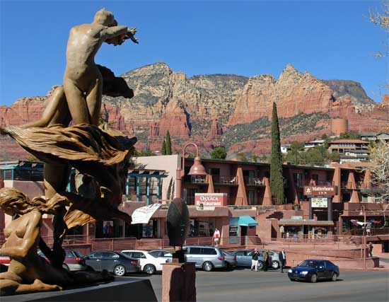
Sauntering back down to the cars, I then thought to head the short way south into Sedona, AZ.
I got free public parking, and walked about this trendy town. Lots of tourists. I snapped many photos, seeking one good one for my website. I had a sandwich at an eatery on a back street. This is a center for artists, and I liked the sets of public sculptures.
Motoring back north, I wondered what to do next. I might do the trail down to the Colorado River in Grand Canyon National Park, for a 5,000' loss/gain trail to do, finally.
I drove west on Interstate 40 to Williams, AZ, to get a cheap room. I walked up and down the main street, and then, on going to the motel, found the rate was high. It was now a weekend, and a new month. The rate was about double what I had paid here, back in February, 2002, on my former Winter Southwest Loop.
Thinking about it, I figured the other motels would be asking just as much. Well, the big hike can wait till another time. I've seen the Grand Canyon already, and with no clouds, it wouldn't be especially interesting for photography. I did have a great cheeseburger and pumpkin pie at a restaurant, so was ready for something to do. As I usually decide, I drove on west to Kingman, AZ. Room rates are lower, there. I could then figure what to do.