OREGON COAST RANGE PEAKS (continued)
Page 3
Tuesday, my last day, I woke up a bit earlier,
and headed out south on Interstate 5. My goal today was Mt. Bolivar,
the high point of Coos County. It was some 35 driving miles west
from the Interstate on backcountry forest roads. I started with
some doubts about doing this, and was checking on the directions,
at least. I found the correct road to head up, and it was paved.
There are some short gravel spots, potholes, and rocks. I recorded
the junction signage and kept track of the route.
 The
road curved on, and it looked pretty good. I passed by a mapboard,
and it showed that I was on track. I soon came to a false peak,
then the road drops considerably. Some would lose faith, and turn
back, or be confused. I went on, and shortly came to the well-signed
trailhead, and parked my car. I hadn't seen anyone since leaving
Glendale, OR, on the approach.
The
road curved on, and it looked pretty good. I passed by a mapboard,
and it showed that I was on track. I soon came to a false peak,
then the road drops considerably. Some would lose faith, and turn
back, or be confused. I went on, and shortly came to the well-signed
trailhead, and parked my car. I hadn't seen anyone since leaving
Glendale, OR, on the approach.
I began my hike
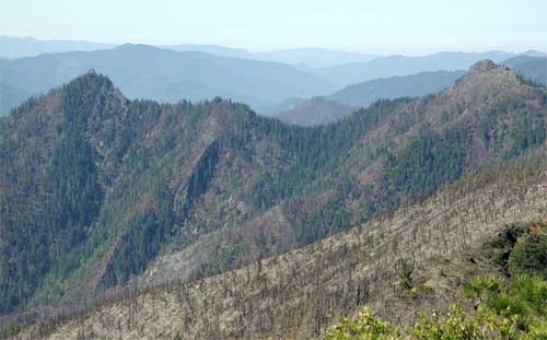
up the trail at 9:32 a.m., and made good time. The south slopes
had been fire ravaged, and all was scorched. I later wished I
had not been rushed, and had thought to carry up some register
cans. There was to be none up there, as I looked.
The trail turns to the north side of the
peak, where forests appeared. I contented myself with a good time,
and shortly summited at 10:19 a.m. The vistas weren't very great,
and I shot photos as record. The plaque on top honored the peak
namesake Venezuelan hero, and I noted the clearcuts, once again.
This peak is in the northern tip of the Wild Rogue Wilderness,
and it looked better, toward that way.
Having another peak to climb, I tarried
not. It was getting warmer, and the sun beat down, a bit uncomfortably.
Failing to get a sharp photo from the bottom of a hanging flower,
too, I wasted time on that. I go through about a 256 MB memory
card a day, with batteries to change, too. I returned to the trailhead
as fast as for my ascent time.
Motoring back east, I then kept track of
the miles. I will have better directions, and photos to boot.
This is a worthwhile time to recommend for County Highpointers.
Finally back to the Interstate, I went south and stopped briefly
at the Wolf Creek Lodge, a national
historic site. I then exited again, in Grants Pass, OR, for rest,
food, and drink.
Missing another freeway exit approaching
Medford, I took a further exit to navigate, by sight, to the Table
Rocks. Upper Table Rock is a preserve
as well as a peak. The regular paved road leads to the well developed
trailhead parking lot. I began to pack what I needed.
 I
started up a fine graded trail by 2:40 p.m., ignoring the posted
warnings about recent cougar sightings. There were other hikers
on the trail. I enjoyed the floral display, and this trail is
noted for madrones. This is a drier clime. In a short time, I
reached the wide, flat topped mesa that forms this peak. I meandered
over to the southeastern side above some cliffs, and shot the
vistas. Snowy Mt. McLoughlin appeared to the east. The scene was
of some mild development, with Medford in the distance. A breeze
helped things, and I knew this was my last peak for the trip.
It was remarkable how well things worked out!
I
started up a fine graded trail by 2:40 p.m., ignoring the posted
warnings about recent cougar sightings. There were other hikers
on the trail. I enjoyed the floral display, and this trail is
noted for madrones. This is a drier clime. In a short time, I
reached the wide, flat topped mesa that forms this peak. I meandered
over to the southeastern side above some cliffs, and shot the
vistas. Snowy Mt. McLoughlin appeared to the east. The scene was
of some mild development, with Medford in the distance. A breeze
helped things, and I knew this was my last peak for the trip.
It was remarkable how well things worked out!
Starting down, I looked for better wildflowers
to shoot, then came back to my icy drink left in the car. I spent
an hour and a half here, total. I motored south, then west, to
the Interstate, and headed for home.
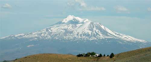
Paying up to 3.499 for gas (at an isolated
exit), I stopped for some telephotos of Mt.
Shasta (photo below). I zoomed south, and refreshed myself
more with drink, food, and rest. Huge thunderheads had built up
over the Cascades, and alpenglow lit up the billowing clouds above
Lassen Peak. That was a nice sight to cap off this little jaunt.
I came home, then, at a fairly good hour.
Hiking some 11,000 feet of gain, I did
some 30 miles, total. I drove nearly 1,900 miles. Using about
48 gallons of fuel, my car gave me about 39 mpg. Yes, I drove
in lower gears some of the time, on mountain roads, and curving
roads. I spent about $250 in cash, and charged up $212 for the
lodging. Shooting roughly 1,800 digital images and movie clips,
I was able to manage my memory use in a more intelligent manner.
The summits sometimes had trees blocking
a full 360 degree panorama. Only two had registers, but the urban
ones seemed frequently hiked. Some Pacific Southwest summiteers
would be wondering why no one has thought to remove the trees
from parts of the vistas. Because the forests continue thickly
down from the top, I didn't get any pictures of the summit views
in certain directions.
I mostly wore just a T-shirt and light
pants, with another light layer on, at times. Only once did I
put on a heavier jacket, on a chilly morning up Mary's Peak. There
were record highs during this time period. I had some camping
gear along, should I have decided to do any. I drank about six
liters of water, total, on the hikes, with gallons of diet soda,
energy drink, and light lemonade, from mini-marts and fast food
places.
Carrying my heavy day climbing pack for
the remoter peaks, I used a light pack for some hikes that I wasn't
too worried about getting lost, or into some trouble, like on
the urban peaks. I never saw any ticks. There were a few mosquitoes
in spots, but none were very aggressive. I didn't get bitten.
Squirrels, birds, and other insects comprised the wildlife I spotted.
No deer or bear, or any larger wild animal. Lots of dogs with
hikers, though.
So this will be it for the Oregon Coast
Range, as far as accessible peaks, for me. Another area I can
check off! It was nice not to leave any good peaks (known to me)
for the future, as I have other climbs and road trips to do. I
was higher on the Interstate at Siskiyou Summit (4,310') than
on most of the peaks, but I got my exercise, a good, multiple,
draught of scenic, wild beauty, and my curiosity fulfilled.
Thanks to the good looking, professional,
and friendly people who serve travelers! I was so relieved that
nothing terrible happened. Few would want to do any of this, and
I'm pleased that all went so well. Thanks again to Oregon, for
a fine peaks adventure!
BACK TO PETE'S
THOUSAND PEAKS HOME PAGE