OREGON COAST RANGE PEAKS (continued)
Page 2
 Anxious
about how many peaks I would climb, I was to never suspect I would
climb so many, so predictably, for me. Sunday was my biggest day.
I left the motel a bit earlier, and took OR 6 at the junction
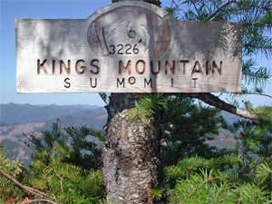
west of town. No one was hiking at the Kings Mountain trailhead,
worrying me a bit. I preferred to have some company, in case something
went terribly wrong, but I was to do O.K.
Anxious
about how many peaks I would climb, I was to never suspect I would
climb so many, so predictably, for me. Sunday was my biggest day.
I left the motel a bit earlier, and took OR 6 at the junction
west of town. No one was hiking at the Kings Mountain trailhead,
worrying me a bit. I preferred to have some company, in case something
went terribly wrong, but I was to do O.K.
Starting up the trail at 8:06 a.m., I made
very good time. These peak trails are steep, but this one was
mostly graded well. An Internet post warned of ticks, so I applied
DEET to my legs and waist. The trail is wide at first, but it
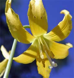
becomes impossible not to brush by plants. I took my time for
photos, and observed my progress
by the trail markers.
 Climbing
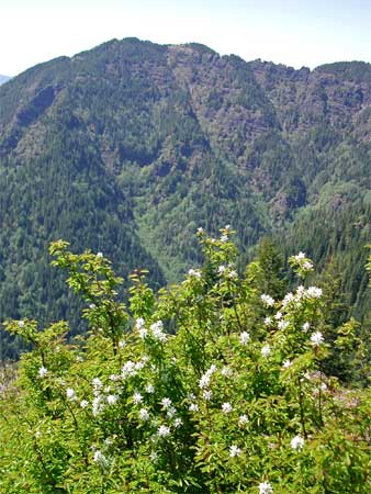
out of the trees, I was seeing the other peaks, then topped out
after 1:42 of hiking. Excellent, for 2,600 feet of gain. A summit
register, inside a large blue plastic tube, was inside an aged
wooden column. I signed in the large notebook, after snapping
my summit view photos. I pondered
about the connecting trail between the peaks. Some advice suggested
not to do it for a solo hiker like me. I had no good maps, and
didn't know the way. It saves some gain, but is further to hike,
as a loop, than going down and starting up Elk Mountain from its
own trailhead.
Climbing
out of the trees, I was seeing the other peaks, then topped out
after 1:42 of hiking. Excellent, for 2,600 feet of gain. A summit
register, inside a large blue plastic tube, was inside an aged
wooden column. I signed in the large notebook, after snapping
my summit view photos. I pondered
about the connecting trail between the peaks. Some advice suggested
not to do it for a solo hiker like me. I had no good maps, and
didn't know the way. It saves some gain, but is further to hike,
as a loop, than going down and starting up Elk Mountain from its
own trailhead.
So, I decided to head the way I had come.
I made it back down after an hour ten, then motored a few miles
back east to the short, side road to Elk Campground and the Elk
Mountain Trailhead. They were finishing cleaning the restroom,
so I used it. It was almost 12 Noon.
 I
was feeling O.K., so drank plenty of water, and started up this
second trail. I expected it to go fast, but it turned into a very
steep trail. My footing would be
poor on the way down. I clambered up what would be class 2 trail,
perspiring heavily in the sun. I knew this wouldn't last, so continued
on. Other hikers came sliding down.
I
was feeling O.K., so drank plenty of water, and started up this
second trail. I expected it to go fast, but it turned into a very
steep trail. My footing would be
poor on the way down. I clambered up what would be class 2 trail,
perspiring heavily in the sun. I knew this wouldn't last, so continued
on. Other hikers came sliding down.
I caught up with an older couple, guided
by bad directions. They were going to do the peak loop, but the
book they had was misleading. They turned around, as we chatted
on the top. I looked through the register, which was filled, and
snapped some sample photos. Nothing like the Sierra Club in L.A.,
with lists, and numbers under the drawn peaks behind peoples'
sign-ins.
I took it slow on my way down. Didn't want
to slip and injure myself. It took about as long to get down,
an hour and three quarters, as to climb each peak, today, and
I was tired. It was early enough in the day, though, so once safely
back to my car, wondered about a third, easy peak today.
Motoring back east, I chose to head for
Larch Mountain, a near drive-up. I hoped that the summit road
was now open, as it was closed a few days ago. I ascertained that
uncertainty, by phone, two days before I left home.
Passing through Portland, I took Interstate
84 east. Turning off at the Corbett Exit, I stopped at a great
vista point of the Columbia River Gorge, signed the Portland Womens
Forum. I was to stop here again on my way down, for a great dusk
photo.
Needing to use a facility, I had to stop
and use a tree. Then, I saw the summit road was open. Snow along
the shoulder appeared. There was two or three feet of snow on
the berm, in spots. I was so lucky!
The parking lot was plowed, and I was able
to display my NPS park passport on my dash. This is a USFS fee
area. I hiked on snow to the vista point,
with families about. It may be a stretch of mine to count this
as a peak ascent, but it is high, and prominent. The views are
touted as one of the best of so many Cascade peaks.
 The
view platform, Sherrard Point, is surrounded by a fence. I quickly
stepped over it to clamber up the adjacent, class 2, highpoint
rock, with fine holds. There is some exposure on the far side,
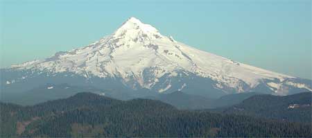
but I was safe enough. I started to use my telephoto lenses, and
Mt. Hood was the closest volcano. Rainier was too far away to
be seen, today, due to haze.
The
view platform, Sherrard Point, is surrounded by a fence. I quickly
stepped over it to clamber up the adjacent, class 2, highpoint
rock, with fine holds. There is some exposure on the far side,
but I was safe enough. I started to use my telephoto lenses, and
Mt. Hood was the closest volcano. Rainier was too far away to
be seen, today, due to haze.
I snapped a group shot for the family,
then they went down. Others were still coming up. The sunset wasn't
to be that great, with no clouds to turn red. I wished for a great
night shot of the lights of Portland, but it was so distant. The
sun reflected off the Columbia River to the west. All or most
of these parks and vista points have hours of use.
While walking back to the parking lot,
I heard a shrill whistle. I mentioned this to another visitor,
and then more people heard it, too. One fellow yelled to whistle
twice if they (?) heard us yelling, but the sound continued, unresponsive.
I figured it was a bird of the Northwest. The fellow had a cell
phone, so he called 911. I figured they'd think it was nothing,
after talking about it. Terrible, if it was a lost hiker,
with us ignoring it.
I motored off, and soon saw a patrol car
speeding up the hill, lights flashing, followed by another. What
did that guy say? I stopped again at the Gorge vista point, and
the fellow came by. He told me that his cell phone had dropped
the connection, so I guess that they responded to what they must
have first heard--lost hiker. Horrible mistake. I just hoped it
came to nothing, and the fellow spoke to a Washington State dispatcher
to explain. I felt badly, but it was due to poor reception.
I shot more pictures of the Gorge--it was
beautiful. My legs were tired, but
I had bagged both hike peaks, and got this third one, too. I munched
down some roast beef sandwiches once back to civilization, shaken
a bit. It was late. I would have rather had a great dinner to
celebrate my day.
Taking Interstate 84 back into Portland, I enjoyed a great, close-by,
night panorama of the downtown skyline from the I-5 bridge over
the Willamette River. Wish I could walk out and get a shot! No
pedestrian walkway, though.
So back to my motel, I watched more TV,
and recharged more batteries. I read my books and maps for what
to do next.
Monday, I checked out of the motel, and
headed south. I stopped in Salem to visit the State
Capitol. Not much else to see.
 Then,
it was back to Eugene. Taking Willamette Street south out of town,
I found the trailhead parking for Spencer Butte. This is a prominent
park and rec area, with fine forests to hike through. No fees.
I started up this point by 10:28 a.m., and took the steeper northern
side to the top. A few other users were about, too. I topped out
in 25 minutes, and recorded the nice views,
with hazy, high overcast. It was nice enough, but with record
highs forecast for today. Eugene was far distant, but the Willamette
Valley and the surrounding ranges made for photos.
Then,
it was back to Eugene. Taking Willamette Street south out of town,
I found the trailhead parking for Spencer Butte. This is a prominent
park and rec area, with fine forests to hike through. No fees.
I started up this point by 10:28 a.m., and took the steeper northern
side to the top. A few other users were about, too. I topped out
in 25 minutes, and recorded the nice views,
with hazy, high overcast. It was nice enough, but with record
highs forecast for today. Eugene was far distant, but the Willamette
Valley and the surrounding ranges made for photos.
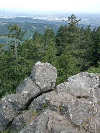
After ambling over to a better view toward the north, I started
down on trail on the far, southeast side of the butte. Lots of
poison oak. Soon, I was back in thick forest, and enjoying doing
this hike. Many hardcore peak baggers might ridicule such easy
urban hikes as "peaks," but they are exotic enough,
for me, so that I'll count them. I don't get up here enough to
regard these as so mundane.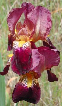
I headed back over the freeway on to my
next hike--Mt. Pisgah, which I had just decided to do. A fee must
be paid, then I started up at 12:50 p.m., in light heat. A dirt
road leads to the top. This peak is
mostly cloaked in oaks and grasses, with a power line running
through the place. I liked the many irises, and, as everywhere
this trip, just how green it all was.
Summiting in 45 minutes, I talked with
some locals, and they guessed at some names for the peaks to see.
I left to head back down, with lots of time, today. With my now
lower standards for peaks, I began to formulate the number, "nine,"
for the total count for this trip. That was pretty heady.
Refreshing myself again with cold drink
and some food, I continued south on Interstate 5. I'd get to the
motel in Roseburg, OR, and have lots of time to relax. I got the
good rate, then the best meal for the trip. A decaf cappuccino
for dessert, made and served by a cute gal, was followed by my
circuitous return to my motel, due to freeway construction. I
fell asleep earlier.
Next