LAVA BEDS NATIONAL MONUMENT ROAD
TRIP June 22-23, 2005
Eager
to start my summer travels, I decided to do this road trip on
short notice. It had been some 18 years since I have last visited
this underused National Monument in Northeastern California.
 Leaving
in the late morning, Wednesday, I motored quickly north on Interstate
5. I was to shell out the highest amount (2.619/gal.) I have ever
paid for gas. Luckily, I believe in fuel efficiency, and get the
most out of each tank of fuel. Reaching Mt. Shasta City, I stopped
at the ranger station to see what was new about climbing Mt. Shasta.
It looked like all is well, there.
Leaving
in the late morning, Wednesday, I motored quickly north on Interstate
5. I was to shell out the highest amount (2.619/gal.) I have ever
paid for gas. Luckily, I believe in fuel efficiency, and get the
most out of each tank of fuel. Reaching Mt. Shasta City, I stopped
at the ranger station to see what was new about climbing Mt. Shasta.
It looked like all is well, there.
Getting a motel room in Weed, CA, I then
headed north on I-5 to miss the exit for a short evening drive
into the Klamath Mountains. Looking at my maps, I turned back
to head south on old U.S. 99, a celebrated, old, historic highway.
Passing through the small town of Gazelle, I headed west toward
Callahan, enjoying the nice scenery. There were some vistas at
unsigned Gazelle Mountain Pass (4,921'). Sights of cattle grazing
peacefully under high hills and snowy peaks made for a pretty
scene.
I had in mind a pristine mountain hillside
that I had seen on a long-ago, peak climbing trip. This was one
of my past regrets for not snapping a photo, then. My memory was
hazy, and what seemed to be the once evenly forested hillside
proved not to be. There had been mudslides, and perhaps some logging.
Motoring north on Highway 3 to the town of Etna showed to myself
that the hill south of Callahan must have been the verdant slope.
I toured the historic old town, while here at Etna, and shot many
photos. These are quiet, pleasant, and uncrowded, places to live,
but not as spectacular as other mountain towns. The Scott and
Marble Mountains are nice, but not anything like the far more
rugged Wyoming Tetons, say, or the Idaho Sawtooth. The views were
nice and green, though, with still snowy peaks in the distances.
Motoring back to Weed, I had a sandwich
for dinner, and watched a movie, then the news, on cable.
I figured to return home, Thursday, since
this national chain motel had peremptorily raised the rates from
what was stated in their directory for this year. Just too expensive
for what are mainly local mountains! But first, I headed northeast
on U.S. 97, to get the views
of Mt. Shasta's northern side, with its glaciers and ice fall.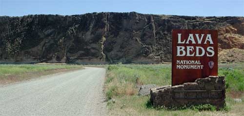
Lava Beds National Monument is not too
much further. I took CA 161 east along the Oregon border, then
back south past a wildlife refuge. The monument ($10 entry fee)
has self-pay facilities instead of staffed entrance stations.
I hiked Captain Jack's Stronghold, and
visited the Canby Cross. Next was Black Crater, a short hike,
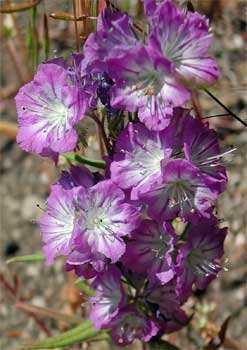
then my bump for this trip, Schonchin Butte. The views came out
hazy in my photos, but there were flower displays. This trail
hike took some 20 minutes to the top. No lookout was on duty.
Coming to the main visitor center, I found
the gravel road past Medicine Lake to CA 89 was still closed by
snow. Disappointed, I went back north to a newer addition to the
park, Petroglyph Point. Thousands of rock
art carvings, made by ancient man, are located about this
detached corner of the park. I recorded the better examples I
could find.
To CA 139, I stopped at Tulelake, CA, to
visit the museum ($3.00 for adults). Dwelling largely on World
War II local history, some space was devoted to the 1940's internment
camp for Japanese-Americans, sited nearby, to which many came
from the Central Valley. The small town has some interesting buildings.
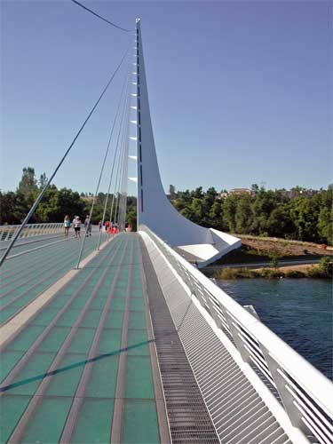 The
drive back home was uneventful, with a stop to photograph historic
Dunsmuir, and then the Turtle Bay Sundial Bridge in Redding, CA.
I discovered the right I-5 exit, CA 44 west, this time, which
quickly leads to the park area. I would like to hike the river
trail here in another winter.
The
drive back home was uneventful, with a stop to photograph historic
Dunsmuir, and then the Turtle Bay Sundial Bridge in Redding, CA.
I discovered the right I-5 exit, CA 44 west, this time, which
quickly leads to the park area. I would like to hike the river
trail here in another winter.
My total drive was a bit over 800 miles.
I had hiked probably only 4 miles, with just a few hundred feet
of gain, all together. I used some 500 MB worth of digital memory,
with some 460 images. The weather was nice, requiring only one
additional layer at night, with shorts fine, most of the time.
There were clouds of mosquitoes about the refuge marshes, and
I saw no ticks. I disbursed $27 for gas, enroute, although starting
with nearly a full tank, and coming back with an empty tank. Maybe
$12 for food and drink.
After a decade or two, it seems worthwhile
to revisit parks and monuments. Due to some uncertainty, I doubt
I'll see the Rocky Mountains National Parks this summer, and my
hoped-for, ten big peaks to climb now looks better to do in another
year. A bad scare about car problems just has me sitting on edge,
figuring a few trips to the High Sierra, or other peaks relatively
close by, may be enough for me, this season!
BACK TO PETE'S THOUSAND
PEAKS HOME PAGE