JENKINSON LAKE September 28,
2005
Seeking
to make a short drive to help resolve potential car problems,
without a partner, and with the still high prices of gas (2.839
yesterday), I chose this proximate destination for a medium hike.
The local Sierra Club chapter had long conducted this circle hike,
for reasons that are now pretty obvious. This trail around Jenkinson
Lake (elevation 3,471', although the lake level fluctuates) is
fairly flat (compared to a peak climb), well-signed, and with
many, many, facilities, once to the north shore. Also, if one
became severely tired, or immobilized, rescue would be easy. Shouting
to the boaters on the lake, I'd expect a ride, over the water,
could be simply procured.
 Leaving
home at about noon, I took busy U.S. 50 eastbound. Using a fast
food restaurant in Placerville, CA, I shortly motored to the Sly
Park Road exit, Exit 60. You follow the route of signed, Alternate
U.S. 50, and county road E16, southeast to this reservoir. Make
a signed turn left (east), cross the two dams, and then park right
past the east (far) end of the second dam. There are only a few
primitive spots, off the road, right past where the "Southshore"
trail begins, but one could simply backtrack to other parking
areas, and hike to this trail's start.
Leaving
home at about noon, I took busy U.S. 50 eastbound. Using a fast
food restaurant in Placerville, CA, I shortly motored to the Sly
Park Road exit, Exit 60. You follow the route of signed, Alternate
U.S. 50, and county road E16, southeast to this reservoir. Make
a signed turn left (east), cross the two dams, and then park right
past the east (far) end of the second dam. There are only a few
primitive spots, off the road, right past where the "Southshore"
trail begins, but one could simply backtrack to other parking
areas, and hike to this trail's start.
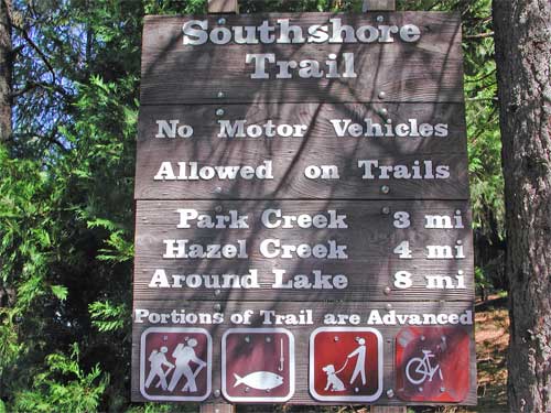
The big trailhead sign displays the distances.
I began hiking at 1:28 p.m., with no facilities here. I was in
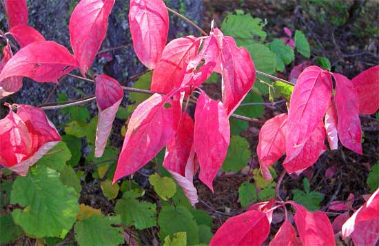
search of an early, dogwood, fall color show, which presented
itself quickly. The leaves were nicely pale red, and I stopped
at many a tree for photos. The shady forest is a bit dim, so a
steady hand or a tripod is needed. Some of my photos turned out
a bit blurred, and my auto flash went off a lot.
Past the major color in the first mile
or so, I ventured on, to make an exploration. It is signed, "eight
miles," around the lake. Maybe four hours, at most. I sauntered
along, running into other users. One gentleman, at 73, chatted
for awhile. The only mosquito I ever saw, this day, landed on
his ear. There is very little, if any, poison oak, a plague of
the foothills. I saw no ticks, but plenty of other, harmless,
bugs. I cannot emphasize enough that you must get medical attention
upon being bit by a tick. A former peak associate has now passed
away, diagnosed with Lyme disease. He must have neglected it until
after it was too late.
There are plenty more dogwood, still green,
further along. An occasional, yellow set of leaves, from oaks
or chinquapin, appears. I was now trying to make good time. Coming
around two arms of the reservoir, it would truly appear to be
a good hike. At Park Creek, there is a nice footbridge. Another
short, footbridge over another arm of the lake is crossed, then
I came to a long stretch of recreational development. Many a campground,
with numerous facilities, supplying faucets and running water,
lined the north shore. Upon reaching the paved road, only about
4 miles, counterclockwise, into the circle hike, I suppose hikers,
who have had enough, could call, by cell phone, perhaps, for a
ride from a friend with a car.
A mapboard shows the lake, trails, and
what's provided, here, at the far end of this lake. The signs
indicate "Sierra Trail," "Chimney Trail,"
and "Miwok Trail." I simply navigated along the closest
trail, or road, to the lakeshore. This area could hold many campers
and picnickers.
 Now
with a straight shot back, I rushed along. Waving a hello to many
other users, I shot photos of the trail, with tall, straight-trunked,
trees on both sides, here. Yes, this is all a nice forest hike,
shaded for most of the way. A few anglers were fishing.
Now
with a straight shot back, I rushed along. Waving a hello to many
other users, I shot photos of the trail, with tall, straight-trunked,
trees on both sides, here. Yes, this is all a nice forest hike,
shaded for most of the way. A few anglers were fishing.
I disdain reservoirs in favor of pristine
mountain lakes, but water development is the main reason that
facilities are built, and access is provided. Most of the campgrounds
were now empty, but this is a nice, out-of-the-way, place.
Past the boat ramp, I shortly came back
to the paved highway, the Mormon-Emigrant Road. I have driven
this way, enroute to the High Sierra, probably a hundred times,
but until now, never knew this circle hike, completely.
I was able to use trails along the paved
highway, then walked along the asphalt, over the two dams, to
come to my car. Back at 5:03 p.m., this walk had taken me a total
of just over 3.5 hours. I drank up my liter bottle of water, then
shortly motored off.
On my way home, I stopped at the Placerville
library to catch a few magazines they don't have in town.
The hike was 8 miles, with roughly 500'
gain. There are numerous 20'-40' hills, with dips, that this trail
climbs over. I shot 136 images. My car used only about a quarter
tank, maybe 3 gallons, for my 125 mile round trip.
Wearing only a T shirt and shorts, I carried
a light pack, for once. My cap was useful. I never used my back-up
camera. I saw a ladybug swarm at the far end of the lake, with
a few clouds of gnats. No wildlife to see, aside from birds and
occasional chipmunks or squirrels. To see so many users on a midweek,
Wednesday, was a surprise.
Once I get my car issues resolved, I may
stay about home, doing local peaks, given the present, hurricane-related,
national urgings to conserve gas. With all the peaks I've done
so many times, my only urge is to share my knowledge, lead a climb,
and give rides, or carpool, for interested hikers and climbers,
with my energy efficient, 40+ miles per gallon, transportation.
BACK TO PETE'S THOUSAND
PEAKS HOME PAGE