 GREAT
BASIN FALL COLORS ROAD TRIP: GRANITE PEAK (9,732') 2X, STEENS
MOUNTAINS (9,733'), AND CINDER CONE (6,907') 3X October 1-3, 2004
GREAT
BASIN FALL COLORS ROAD TRIP: GRANITE PEAK (9,732') 2X, STEENS
MOUNTAINS (9,733'), AND CINDER CONE (6,907') 3X October 1-3, 2004GREAT
BASIN FALL COLORS ROAD TRIP: GRANITE PEAK (9,732') 2X, STEENS
MOUNTAINS (9,733'), AND CINDER CONE (6,907') 3X October 1-3, 2004
Unforeseen expenses dictated that I drop my plans for a Utah and Southern Nevada road trip to catch the fall colors. I thought of a shorter trip, going to Winnemucca, NV, and visiting ranges to its north.
Leaving home at 1:30 a.m. Friday, I took Interstate 80 eastbound in the lesser used wee hours, and stopped in Reno for a rib-eye steak and eggs breakfast (8.25, now). Losing a bit trying for a Ford Thunderbird, I then motored eastward and made great time doing the 75 mph speed limit. Reaching Winnemucca in time to wait for the USFS office to open, I left notice of my hiking plans in case I should incur some terrible incident.
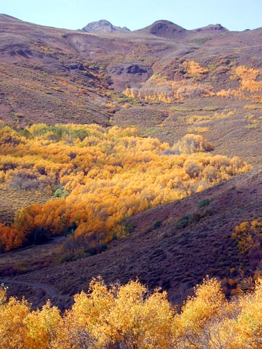
Headed north on U.S. 95, I turned off for Paradise Valley, on NV 290, and then to Hinkey Summit. Parking there, I began hiking west up a dirt road, with views of the aspen here at its peak. Soon following a use trail along a fence line, I did well, remembering the way. After less than two hours, I was scrambling up the final class 2 talus. Topping out, I prepared a new register book, and began to snap photos of the view. Bright groves of gold illuminated the mountains of the Santa Rosa Range to the south and north. Clouds cast their shadows, and the haze was bad (second photo).
I wished to read the old register, but terse sounds and dark clouds caused me to fear for lightning, and I left quickly for lower ground. I was able to rapidly descend, and snapped more photos of the aspen groves on all sides.
Back to my car safely, I stopped in Paradise
Valley, NV, for some photos.
Then, I took off back to Winnemucca. 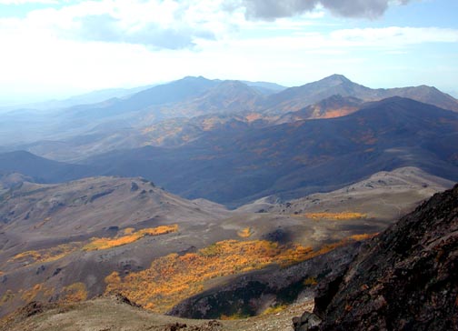 Dropping
into the USFS office to check back, I showed photos, on my camera
LCD, of the colors. I agreed to e-mail some to them to show the
conditions.
Dropping
into the USFS office to check back, I showed photos, on my camera
LCD, of the colors. I agreed to e-mail some to them to show the
conditions.
I secured a cheap room rate, and gladly feasted on a roast beef sandwich. Back to my motel room, I fell asleep by about 6:30 p.m., and then awoke by 4:20 a.m. the next morning.
I had a bigger breakfast, and took off in the night up U.S. 95, again. Turning left (west) on NV 140, I went through Denio, NV, and then stopped in Fields, OR. The southern approach road to Frenchglen, OR, is now all paved.
I came to the Steens Mountains Loop Road, and took the north branch since it was better for my passenger car. I was able to drive up to about 35 mph, the posted speed, on the washboarded gravel. You can avoid the vibrations by keeping your tires in the used and smoothed down track. Groves of aspen at their peak began to appear. I stopped for quick photos, then came to the side road for the Kiger Gorge vista point. Shadows made the photography more difficult, but the scene was grand.
Motoring up further, I came to the parking for the East Rim Viewpoint. I am told that this may be the true highpoint of the range. I made sure I bagged this point, and then hiked the "Steens Summit," 2.5 miles further along, by a half mile trail (dirt road) to a communications facility. The weather was nice. They had gotten some snow recently, and some patches remained. I shot the views in all directions, then started back down to Frenchglen. The light had gotten better, and I shot with all three of my cameras, making sure one glorious fall vista scene was recorded.
Motoring north again, I came to Burns, OR, where I thought at first to stay. There was still plenty of daylight, so I motored south along U.S. 395 and snapped photos of Wagontire, OR, a small stop "in the middle of nowhere." The Abert Rim and Lake Abert made for more photography.
I obtained a room in Lakeview, OR, and hoped to try some Cobb Chicken Salad at a place where I ate six years earlier. The restaurant had changed, without then, the deluxe meal. So, I then had a simple cheeseburger, with soup.
I awoke by about 7 a.m., this third and final day, and headed south to Alturas, CA. I had thought to hike two peaks in the Warner Mountains, but I had no good maps, or the will to do a twelve, or more, mile hike solo.
So, instead, I took a leisurely drive west on CA 299, passing through the towns of Canby, Adin, Bieber, and Fall River Mills. A pullout had made for a photo of the Pit River. Distant views of Shasta and Lassen presented themselves at a good view point. Coming to Burney, CA, I got some breakfast, and drink, then looked for the approach roads to Burney Mountain (7,863'). This is a highly prominent peak in the area, and has a road going to a lookout on top. The roads were bad, or I couldn't find the way, and the ranger stations were closed this day.
I resolved to head south along CA 89 to
Lassen Volcanic National Park. There was some roadwork delay on
CA 44, then I took the dirt road to Butte Lake. I topped Cinder
Cone in under an hour, and snapped the views
of the Painted Dunes and the Fantastic Lava Beds. Big clouds added
some drama. Thinking of hiking Lassen Peak also, I had just taken
too much time.
I came to the Lassen Peak trailhead by about 4:30 p.m. Allowing some two hours for the climb, I would still come back in the dark or dusk. I chose then to drive west, completing the Lassen Loop, and shot many a photo of the many beautiful views.
Taking CA 89 to CA 32, I noted the appearance of early foothill fall colors, with red dogwood and yellow big leaf maples. I had a sandwich in Chico, CA, and got gas. U.S. 99 went fast headed south, and I was home at a good hour.
I hiked only 8.5 miles with 3,000' gain, total. I drove some 1,260 miles, and snapped some 850 images, with 25 frames of Kodachrome. I spent $200 total.
I plan to stay busy reporting and uploading photos in the next few days, and will decide what to do the rest of this hiking season. With a carpool, I'd be still game for Utah, but I can hike there at the parks, this winter, if there is not too much snow!
BACK TO PETE'S THOUSAND PEAKS HOME PAGE